1910s Maps of Socorro County, New Mexico
Explore 6 historic maps of Socorro County from the 1910s. These maps offer a rare glimpse into what life looked like during the 1910s — showing old roads, neighborhoods, homes, and landmarks that have changed or disappeared over time.
Whether you're researching your family's past, planning a metal detecting trip, or studying how Socorro County's landscape evolved across the 1910s, these high-resolution maps are a powerful tool for exploring the history of this region.
- Focus on a specific era: All maps on this page are from the 1910s, giving you a focused view of this time period.
- See what’s changed: Compare century-old streets, trails, and buildings to today's modern landscape using overlays and satellite layers.
- Research with precision: Use these maps for genealogy, historical research, land use analysis, or educational projects.
- View, download, or print: Maps are fully viewable online in high resolution, and can be downloaded or printed for your own records.
Start exploring Socorro County's history through authentic maps from the 1910s. This is your window into the past.
Socorro County, NM maps
(6)- 1916 Map of La Joya
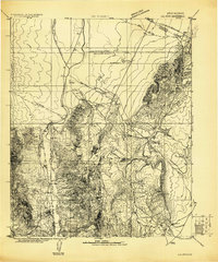 1916 La Joya1916 Print · USGSThe Rio Grande valley at the time of the Belen Cut Off's construction reveals a landscape of massive Spanish land grants and new rail towns. Trace early settlements like La Joya and Becker or geological landmarks like Pyramid Crater.
 - 1916 Map of Salinas Peak
 1916 Salinas Peak1916 Print · USGSSouthern New Mexico was a land of expansive ranches and rail stops in the years before the Great War. You can trace early twentieth-century desert survival through water landmarks like Anaya Spring and rail-side settlements including Engle and Cutter.
 - 1916 Map of Tularosa
 1916 Tularosa1916 Print · USGSNew Mexico ranching and railroading define this pre-war survey of the valley during its early years of statehood. Genealogists and historians can trace family landholdings at Jackson Ranch and Chosa Ranch or follow the path of the El Paso and Southwestern railroad.2 unique versions available
 - 1917 Map of Cerro Verde
 1917 Cerro Verde1917 Print · USGSNorthwestern New Mexico’s high desert landscape is captured here during the First World War era, showing a mix of ancient land grants and rail-side outposts. Genealogists and historians can trace family-named sites like Vigil, Baca, and the Correo Post Office along the Atchison Topeka and Santa Fe line.
 - 1917 Map of Broom Mountain
 1917 Broom Mountain1917 Print · USGSValencia County at the close of the First World War shows a landscape of high mesas and scattered homesteads. Genealogists and historians can trace early ranching outposts like Bodenheimer and Th Garcia or locate the former Miller Post Office.
 - 1918 Map of Oscura Peak
 1918 Oscura Peak1918 Print · USGSSocorro and Lincoln counties appear here in the early twentieth century as a landscape of isolated ranches and rugged mining prospects. Genealogists and historians can locate early family-named sites like Bursum, Estey, and Chihuahua Ranch near the Oscura Range.
End of results
Showing maps 1-6 of 6
Top cities of Socorro County
Frequently asked questions
- What are the different types of historical maps available for Socorro County?
- What is the oldest map of Socorro County?
- Where can I purchase historical maps of Socorro County for my home or office?
- Where can I download high-res historical maps of Socorro County?
- Are there historical topographic maps available for Socorro County?
- Is there historical aerial imagery available for Socorro County?
- Where are historical maps of Socorro County sourced from?