1970s Maps of Beaufort County, North Carolina
Explore 4 historic maps of Beaufort County from the 1970s. These maps offer a rare glimpse into what life looked like during the 1970s — showing old roads, neighborhoods, homes, and landmarks that have changed or disappeared over time.
Whether you're researching your family's past, planning a metal detecting trip, or studying how Beaufort County's landscape evolved across the 1970s, these high-resolution maps are a powerful tool for exploring the history of this region.
- Focus on a specific era: All maps on this page are from the 1970s, giving you a focused view of this time period.
- See what’s changed: Compare century-old streets, trails, and buildings to today's modern landscape using overlays and satellite layers.
- Research with precision: Use these maps for genealogy, historical research, land use analysis, or educational projects.
- View, download, or print: Maps are fully viewable online in high resolution, and can be downloaded or printed for your own records.
Start exploring Beaufort County's history through authentic maps from the 1970s. This is your window into the past.
Beaufort County, NC maps
(4)- 1978 Map of Farmlife
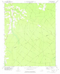 1978 Farmlife1978 Print · USGSThe Martin and Beaufort county line area is captured here during the late 1970s, showcasing a landscape of timber tracts and small rural communities. Genealogists can locate family landmarks such as Manning Cem, Maple Grove Ch, and the Manning Farmlife Sch.
 - 1978 Map of Hoke
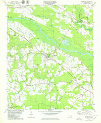
 1978 Hoke1978 Print · USGSCoastal North Carolina's timber and rail country is captured here during the mid-seventies, showing the intersection of Beaufort and Washington counties. Genealogists can locate family burial sites along Long Ridge Road and historic congregations like Christian Hope Ch.
 - 1979 Map of Leggetts Crossroads
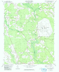 1979 Leggetts Crossroads1979 Print · USGSPitt and Beaufort counties were characterized by vast wetlands and international broadcasting infrastructure in the late 1970s. Researchers can locate dozens of family cemeteries and rural landmarks like the Voice of America (Site A) facility and Pactolus.
 - 1979 Map of Grimesland, 1980 Print
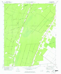
 1979 Grimesland1980 Print · USGSThe Pitt and Beaufort County line in the late seventies reveals a landscape of riverfront landings and rail-linked crossroads. Genealogists can trace family names at Hams Crossroads or locate rural sites like White Oak Ch and Yankee Hall.
End of results
Showing maps 1-4 of 4
Top cities of Beaufort County
- Washington historical maps
- Belhaven historical maps
- Chocowinity historical maps
- Aurora historical maps
- Washington Park historical maps
- Bath historical maps
See more
Frequently asked questions
- What are the different types of historical maps available for Beaufort County?
- What is the oldest map of Beaufort County?
- Where can I purchase historical maps of Beaufort County for my home or office?
- Where can I download high-res historical maps of Beaufort County?
- Are there historical topographic maps available for Beaufort County?
- Is there historical aerial imagery available for Beaufort County?
- Where are historical maps of Beaufort County sourced from?