1960s Maps of Beaufort County, North Carolina
Explore 2 historic maps of Beaufort County from the 1960s. These maps offer a rare glimpse into what life looked like during the 1960s — showing old roads, neighborhoods, homes, and landmarks that have changed or disappeared over time.
Whether you're researching your family's past, planning a metal detecting trip, or studying how Beaufort County's landscape evolved across the 1960s, these high-resolution maps are a powerful tool for exploring the history of this region.
- Focus on a specific era: All maps on this page are from the 1960s, giving you a focused view of this time period.
- See what’s changed: Compare century-old streets, trails, and buildings to today's modern landscape using overlays and satellite layers.
- Research with precision: Use these maps for genealogy, historical research, land use analysis, or educational projects.
- View, download, or print: Maps are fully viewable online in high resolution, and can be downloaded or printed for your own records.
Start exploring Beaufort County's history through authentic maps from the 1960s. This is your window into the past.
Beaufort County, NC maps
(2)- 1968 Map of Bayboro, 1970 Print
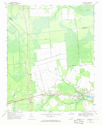 1968 Bayboro1970 Print · USGSCoastal Pamlico County was a landscape of rail and river commerce in the late sixties. Trace the Norfolk Southern line through Grantsboro or locate local landmarks like St Marks Ch and the Central Sch in Bayboro.3 unique versions available
 - 1969 Map of Reelsboro, 1970 Print
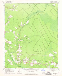 1969 Reelsboro1970 Print · USGSCoastal North Carolina's rural lowlands are captured here in the late sixties, centered on the railroad corridor through Reelsboro and Olympia. Researchers can trace family history through local landmarks like Hollywood Cemetery and the Norfolk Southern rail line.3 unique versions available
End of results
Showing maps 1-2 of 2
Top cities of Beaufort County
- Washington historical maps
- Belhaven historical maps
- Chocowinity historical maps
- Aurora historical maps
- Washington Park historical maps
- Bath historical maps
See more
Frequently asked questions
- What are the different types of historical maps available for Beaufort County?
- What is the oldest map of Beaufort County?
- Where can I purchase historical maps of Beaufort County for my home or office?
- Where can I download high-res historical maps of Beaufort County?
- Are there historical topographic maps available for Beaufort County?
- Is there historical aerial imagery available for Beaufort County?
- Where are historical maps of Beaufort County sourced from?