1980s Maps of Beaufort County, North Carolina
Explore 6 historic maps of Beaufort County from the 1980s. These maps offer a rare glimpse into what life looked like during the 1980s — showing old roads, neighborhoods, homes, and landmarks that have changed or disappeared over time.
Whether you're researching your family's past, planning a metal detecting trip, or studying how Beaufort County's landscape evolved across the 1980s, these high-resolution maps are a powerful tool for exploring the history of this region.
- Focus on a specific era: All maps on this page are from the 1980s, giving you a focused view of this time period.
- See what’s changed: Compare century-old streets, trails, and buildings to today's modern landscape using overlays and satellite layers.
- Research with precision: Use these maps for genealogy, historical research, land use analysis, or educational projects.
- View, download, or print: Maps are fully viewable online in high resolution, and can be downloaded or printed for your own records.
Start exploring Beaufort County's history through authentic maps from the 1980s. This is your window into the past.
Beaufort County, NC maps
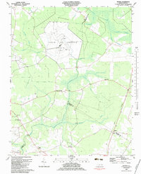
(6)- 1983 Map of Ernul
 1983 Ernul1983 Print · USGSIn the early 1980s, the rural border of Craven and Beaufort counties remained a landscape of vast wetlands and isolated crossroads. Researchers can trace family history through sites like Macedonia Ch or follow the legacy of the Norfolk Southern rail line as it skirts the Big Pocosin.
 - 1983 Map of Wilmar
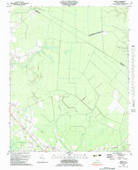
 1983 Wilmar1983 Print · USGSThe Pitt and Beaufort county lines meet in the early eighties at the massive Voice of America (Site B) radio facility. Genealogists and historians can trace local landmarks like Elmira Crossroads and Oak Grove Ch.
 - 1985 Map of Rocky Mount
 1985 Rocky Mount1985 Print · USGSThe eastern North Carolina coastal plain in the mid-eighties shows a landscape defined by its river-and-rail heritage. Genealogists and local historians can trace the development of Rocky Mount, Greenville, and Wilson, or locate landmarks like East Carolina University and the Voice of America site.2 unique versions available
 - 1985 Map of Kinston
 1985 Kinston1985 Print · USGSCoastal plain life and Cold War infrastructure meet in the mid-eighties as the Neuse River winds through agricultural heartlands. Researchers can locate family landmarks like Falling Creek Cem, old milling sites such as Tulls Mill, and the massive Voice of America Radio Towers.2 unique versions available
 - 1985 Map of Plymouth
 1985 Plymouth1985 Print · USGSThe coastal plains of Washington and Beaufort counties come into focus in the mid-eighties as a region defined by large-scale conservation and water-bound trade. Researchers can trace the layout of small farming towns like Pantego and Creswell alongside the vast waters of Phelps Lake and Lake Mattamuskeet.2 unique versions available
 - 1985 Map of Bayboro, 1990 Print
 1985 Bayboro1990 Print · USGSCoastal Pamlico and Beaufort counties are shown in the mid-eighties as a maritime landscape of protected wetlands and river-mouth settlements. Researchers can trace the layout of waterfront towns like Oriental, Bayboro, and the historic village of Bath amidst the Pamlico Sound.
End of results
Showing maps 1-6 of 6
Top cities of Beaufort County
- Washington historical maps
- Belhaven historical maps
- Chocowinity historical maps
- Aurora historical maps
- Washington Park historical maps
- Bath historical maps
See more
Frequently asked questions
- What are the different types of historical maps available for Beaufort County?
- What is the oldest map of Beaufort County?
- Where can I purchase historical maps of Beaufort County for my home or office?
- Where can I download high-res historical maps of Beaufort County?
- Are there historical topographic maps available for Beaufort County?
- Is there historical aerial imagery available for Beaufort County?
- Where are historical maps of Beaufort County sourced from?