1900-1909 Maps of Beaufort County, North Carolina
Explore 5 historic maps of Beaufort County from 1900-1909. These maps offer a rare glimpse into what life looked like during the 1900s — showing old roads, neighborhoods, homes, and landmarks that have changed or disappeared over time.
Whether you're researching your family's past, planning a metal detecting trip, or studying how Beaufort County's landscape evolved across the 1900s, these high-resolution maps are a powerful tool for exploring the history of this region.
- Focus on a specific era: All maps on this page are from the 1900s, giving you a focused view of this time period.
- See what’s changed: Compare century-old streets, trails, and buildings to today's modern landscape using overlays and satellite layers.
- Research with precision: Use these maps for genealogy, historical research, land use analysis, or educational projects.
- View, download, or print: Maps are fully viewable online in high resolution, and can be downloaded or printed for your own records.
Start exploring Beaufort County's history through authentic maps from the 1900s. This is your window into the past.
Beaufort County, NC maps
(5)- 1902 Map of Vanceboro, 1968 Print
 1902 Vanceboro1968 Print · USGSCoastal North Carolina at the turn of the century was a landscape of deep swamps and river landings. Genealogists and historians can trace timber tramroads through the Big Pocoson and locate family-named landings like Heath Ldg. and Ipock Ldg. along the Neuse River.
 - 1903 Map of Chocowinity, 1968 Print
 1903 Chocowinity1968 Print · USGSCoastal North Carolina comes alive in the early 1900s as steam power and rail lines intersect along the banks of the Tar River. Researchers can trace old river landings like Yankee Hall Ldg. and family-named landmarks including Woolard Crossroads and Shepherd Millpond.
 - 1904 Map of Vanceboro, 1936 Print
 1904 Vanceboro1936 Print · USGSCoastal North Carolina at the turn of the century shows a landscape dominated by vast wetlands and the early timber industry. Researchers can trace historic river landings like Vanceboro Ldg. and Wilkes Ldg. or follow the old Tramroad routes through the Big Pocoson.
 - 1905 Map of Chocowinity
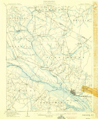 1905 Chocowinity1905 Print · USGSCoastal North Carolina during the early 1900s centered on the busy waterways of the Tar River and the growing town of Washington. Genealogists and historians can trace old river landings such as Yankee Hall Ldg. and rural sites like Leggetts Crossroads or Pactolus.3 unique versions available
 - 1905 Map of Vanceboro, 1945 Print
 1905 Vanceboro1945 Print · USGSEastern North Carolina at the turn of the century is a landscape of expansive wetlands and river commerce. Genealogists and historians can trace the early timber industry through networks of Tramroad routes and find long-established river landings like Heath Ldg. and Ipock Ldg. along the Neuse River.
End of results
Showing maps 1-5 of 5
Top cities of Beaufort County
- Washington historical maps
- Belhaven historical maps
- Chocowinity historical maps
- Aurora historical maps
- Washington Park historical maps
- Bath historical maps
See more
Frequently asked questions
- What are the different types of historical maps available for Beaufort County?
- What is the oldest map of Beaufort County?
- Where can I purchase historical maps of Beaufort County for my home or office?
- Where can I download high-res historical maps of Beaufort County?
- Are there historical topographic maps available for Beaufort County?
- Is there historical aerial imagery available for Beaufort County?
- Where are historical maps of Beaufort County sourced from?