1990s Maps of Beaufort County, North Carolina
Explore 7 historic maps of Beaufort County from the 1990s. These maps offer a rare glimpse into what life looked like during the 1990s — showing old roads, neighborhoods, homes, and landmarks that have changed or disappeared over time.
Whether you're researching your family's past, planning a metal detecting trip, or studying how Beaufort County's landscape evolved across the 1990s, these high-resolution maps are a powerful tool for exploring the history of this region.
- Focus on a specific era: All maps on this page are from the 1990s, giving you a focused view of this time period.
- See what’s changed: Compare century-old streets, trails, and buildings to today's modern landscape using overlays and satellite layers.
- Research with precision: Use these maps for genealogy, historical research, land use analysis, or educational projects.
- View, download, or print: Maps are fully viewable online in high resolution, and can be downloaded or printed for your own records.
Start exploring Beaufort County's history through authentic maps from the 1990s. This is your window into the past.
Beaufort County, NC maps
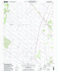
(7)- 1997 Map of Wilmar, 2000 Print
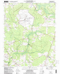 1997 Wilmar2000 Print · USGSThe rural borders of Pitt, Beaufort, and Craven counties are captured here in the late nineties, featuring the expansive VOICE OF AMERICA (Site B) facility. Genealogists and local historians can locate several rural congregations, including Oak Grove Ch and Tabernacle Ch, plus numerous unnamed cemeteries.
 - 1997 Map of Hackney, 2001 Print
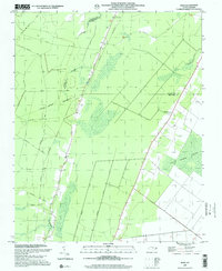
 1997 Hackney2001 Print · USGSCoastal North Carolina lowlands appear in detail near the turn of the millennium, showing a landscape defined by water and wetlands. Genealogists can trace family landmarks like Edwards Cem and local schoolhouses like Maple Grove Sch or Claybottom Sch.
 - 1997 Map of Ransomville, 2001 Print
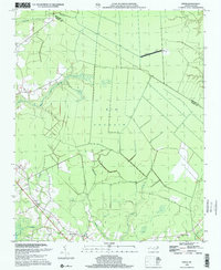
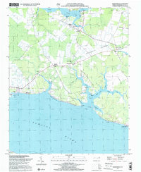 1997 Ransomville2001 Print · USGSCoastal Beaufort County at the end of the century is a landscape of expansive wetlands and quiet river landings along the Pamlico River. Genealogists and local historians can trace family-named sites like Winsteadville, Sidney Crossroads, and Holly Grove Ch.
 - 1997 Map of Farmlife, 2001 Print
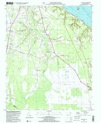
 1997 Farmlife2001 Print · USGSThe coastal plain of Martin and Beaufort counties comes into focus in the late nineties, showing a landscape defined by drainage canals and rural tradition. Genealogists can locate Manning Cem, Maple Grove Ch, and the Manning Farmlife Sch.
 - 1997 Map of Pike Road, 2001 Print
 1997 Pike Road2001 Print · USGSCoastal North Carolina at the end of the century is defined here by the massive engineering of the East Dismal Swamp. Genealogists and local historians can trace the rural communities of Wenona and Pike Road, along with landmarks like Morning Star Ch and the Old Turnpike.
 - 1997 Map of Hoke, 2001 Print
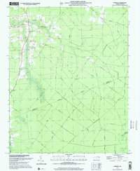
 1997 Hoke2001 Print · USGSCoastal North Carolina at the end of the millennium is characterized here by its vast wetlands and rural railroad hamlets. Genealogists and historians can trace family plots near Christian Hope Ch or follow old timber routes like the Morris Tram Road near Hoke.
 - 1998 Map of Ernul, 2001 Print
 1998 Ernul2001 Print · USGSCoastal plain wetlands and small rural congregations define this pocket of Craven County at the close of the twentieth century. Researchers can trace family sites at Ernul or locate landmarks like Macedonia Ch and the expansive Big Pocosin.
End of results
Showing maps 1-7 of 7
Top cities of Beaufort County
- Washington historical maps
- Belhaven historical maps
- Chocowinity historical maps
- Aurora historical maps
- Washington Park historical maps
- Bath historical maps
See more
Frequently asked questions
- What are the different types of historical maps available for Beaufort County?
- What is the oldest map of Beaufort County?
- Where can I purchase historical maps of Beaufort County for my home or office?
- Where can I download high-res historical maps of Beaufort County?
- Are there historical topographic maps available for Beaufort County?
- Is there historical aerial imagery available for Beaufort County?
- Where are historical maps of Beaufort County sourced from?