Old Maps of Sheridan County, North Dakota for Genealogy
Trace your family roots with 191 historic maps of Sheridan County. These high-res maps reveal old neighborhoods, homesites, landmarks, and streets — helping you uncover where your ancestors lived and how the area evolved over time.
- Explore historic neighborhoods: Identify where your relatives may have lived in the 1800s or 1900s.
- Compare maps over time: Trace the changes in streets, buildings, and landmarks for multi-generational research.
- Perfect for genealogy & ancestry research: Used by family historians and researchers to map out lineage and migration.
These maps are an incredible resource for exploring your personal connection to Sheridan County's past.
Sheridan County, ND maps
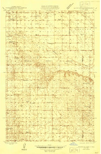
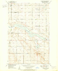
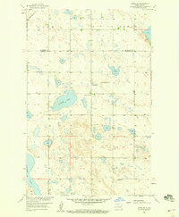
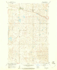
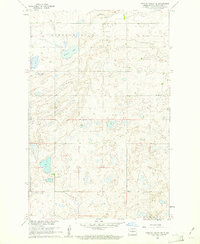
(191)- 1929 Map of Balfour
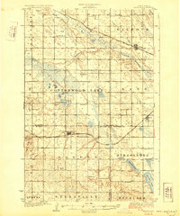 1929 Balfour1929 Print · USGSNorth Dakota's central plains in the late twenties reveal a landscape of homesteads and rail towns along the Minneapolis St Paul and Sault Ste Marie. Genealogists can locate rural schoolhouses like Fleming School and trace the shores of Cottonwood Lake or Krueger Lake.
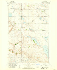
 - 1930 Map of Drake
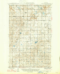
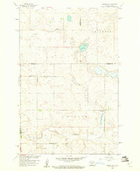
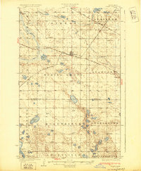 1930 Drake1930 Print · USGSRailroad expansion in the late twenties centered on Drake, where two major lines met amidst the prairie potholes. Genealogists can trace early rural life through a dense network of numbered schools and landmarks like Schiller Hall and Kandt Lake.
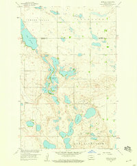
 - 1940 Map of Aylmer
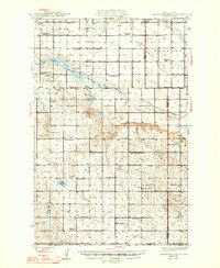
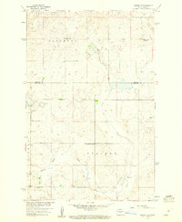
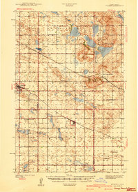 1940 Aylmer1940 Print · USGSPierce and Sheridan Counties come into focus just before the war, showing the peak of the North Dakota rail-and-prairie economy. Genealogists can pinpoint exact locations for family landmarks like Hillsdale Ch, White Sch, and Martin Cem.3 unique versions available
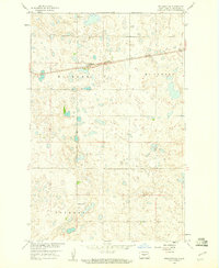
 - 1945 Map of Pelican Lake, 1955 Print
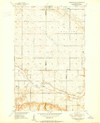
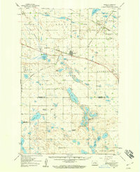
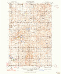 1945 Pelican Lake1955 Print · USGSSheridan and McLean Counties in the mid-1940s reveal a landscape of prairie potholes and tightly-knit rural school districts. Genealogists can trace family footprints through numerous local schoolhouses and landmarks like Our Savior Cem and Immanuel Ch.3 unique versions available
 - 1946 Map of Sheyenne Lake
 1946 Sheyenne Lake1946 Print · USGSSheridan and Wells counties are captured here in the mid-1940s, revealing a dense rural network of prairie schoolhouses and churches. Family historians can trace landmarks like St Emanuel Gemeinde Cem, Sheyenne Lake, and numerous local schools including Pioneer Sch No 1.
 - 1947 Map of Pelican Lake
 1947 Pelican Lake1947 Print · USGSSheridan and McLean Counties in the mid-1940s are characterized by an intricate network of rural school districts and prairie lakes. Genealogists can trace family roots through numerous local landmarks like Immanuel Ch, Our Savior Cem, and Wise Sch No 1.
 - 1947 Map of Lincoln Valley
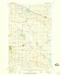
 1947 Lincoln Valley1947 Print · USGSSheridan and Wells Counties are shown in the late 1940s, a time when the North Dakota prairie was dotted with local school districts. Researchers can trace the exact locations of many rural schoolhouses and churches, including Lincoln Valley, Advent Ch, and Skogmo Cem.
 - 1947 Map of Sheyenne Lake
 1947 Sheyenne Lake1947 Print · USGSThe Sheridan and Wells county borderlands are captured here in the late 1940s, showing a landscape defined by an extensive network of rural school districts and prairie lakes. Genealogists can locate family-named landmarks like Mertz Sch No 1, St Emanuel Gemeinde Cem, and the Coal Mine at Coal Lake.2 unique versions available
 - 1950 Map of Sheyenne Lake NE
 1950 Sheyenne Lake NE1950 Print · USGSSheridan and Wells Counties appear here as a landscape of rural schoolhouses and prairie homesteads at the mid-century. Researchers can locate family roots near Zion Cem, the Mennonite Ch, and local landmarks like Fairview Sch No 1 or Pony Gulch.2 unique versions available
 - 1950 Map of Sheyenne Lake
 1950 Sheyenne Lake1950 Print · USGSSheridan County's prairie landscape is captured here in the mid-century, defined by the winding waters of Sheyenne Lake and Coal Mine Lake. Researchers can trace rural school locations like New Germantown Sch No 1 and community anchors including St Johns Ch.2 unique versions available
 - 1951 Map of Martin, 1952 Print
 1951 Martin1952 Print · USGSThe rural prairie landscape surrounding Martin is shown in detail during the early fifties as the railroad connected these remote townships. Genealogists can trace family roots through sites like Reform Cem, Hillsdale Ch, and several local schoolhouses.2 unique versions available
 - 1951 Map of Anamoose SW, 1953 Print
 1951 Anamoose SW1953 Print · USGSSheridan and McHenry counties appear here in the early fifties as a landscape of prairie potholes and isolated farmsteads. Researchers can locate early country schools like Georgetown Sch No 4 and burial sites including Berlin Cem and Baptist Cem.
 - 1954 Map of McClusky, 1968 Print
 1954 McClusky1968 Print · USGSCentral North Dakota was undergoing a profound transformation in the fifties as the newly formed Lake Sakakawea reshaped the Missouri River valley. Genealogists and historians can trace rail-town development along the Soo Line and locate historic markers like Garrison Dam or the Lewis and Clark Trail.3 unique versions available
 - 1958 Map of McClusky
 1958 McClusky1958 Print · USGSCentral North Dakota was undergoing a profound change in the late fifties as the Garrison Reservoir filled behind its massive new dam. Trace the early layout of Riverdale, the Lewis and Clark Trail, and the vanishing rail stops of the Northern Pacific.
 - 1958 Map of Drake, 1959 Print
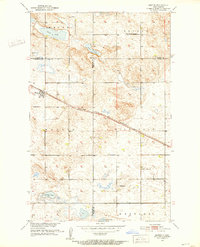
 1958 Drake1959 Print · USGSCentral North Dakota was a landscape of rail-connected prairie towns and scattered farmstead schools in the late fifties. Genealogists and historians can trace the specific locations of Drake, Anamoose, and rural landmarks like the Sons of Herman Cem or Rosenfield Ch.
 - 1958 Map of Balfour, 1959 Print
 1958 Balfour1959 Print · USGSCentral North Dakota was a landscape of rail-connected grain towns and glacial sloughs in the late fifties. Genealogists and local historians can trace family locations near Balfour, Kief, and Butte, or locate rural landmarks like Strassburg Sch No 2 and Kief Cem.
 - 1958 Map of Drake SW, 1959 Print
 1958 Drake SW1959 Print · USGSThe Sheridan and McHenry county line runs through this prairie landscape in the late fifties, showing a rural community tied to its land and water. Researchers can trace local history through Rosenfield Ch, Rosenfield School No 2, and the shores of Kandt Lake.
 - 1958 Map of Kief, 1959 Print
 1958 Kief1959 Print · USGSThe prairie landscape of McHenry County is captured in the late fifties, showing the interplay between the Minneapolis Sault Ste Marie and St Paul rail line and the glacial lakes. Genealogists can locate rural landmarks like Strassburg Sch No 2 and Kief Cem near the town of Kief.
 - 1958 Map of Drake SE, 1959 Print
 1958 Drake SE1959 Print · USGSSheridan County and McHenry County are shown in the late fifties as a landscape of interconnected prairie potholes and rural schools. You can trace family landmarks like Frankhauser Lake and Sandy Lake or locate the site of Rosenfield Sch No 1.
 - 1959 Map of Pickardville, 1960 Print
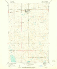
 1959 Pickardville1960 Print · USGSSheridan County's prairie landscape is captured here during the late fifties as rural life revolved around the rail line and township sections. Researchers can trace the Northern Pacific tracks through Pickardville or locate the rural School No 1.2 unique versions available
 - 1959 Map of Mercer, 1960 Print
 1959 Mercer1960 Print · USGSThe prairie town of Mercer appears at the height of its mid-century development along the Northern Pacific railroad. Genealogists and historians can trace rural landmarks like Zion Ch and School No 2 across the county line.
 - 1959 Map of Mercer SW, 1960 Print
 1959 Mercer SW1960 Print · USGSNorth Dakota's prairie borders are captured here in the late fifties, showing the rural crossroads of three counties. Genealogists and historians can trace old homestead districts through Park Sch No 2, Bethel Cem, and the path of Painted Woods Creek.2 unique versions available
 - 1959 Map of Mercer SE, 1960 Print
 1959 Mercer SE1960 Print · USGSThe prairie border of Burleigh and Sheridan counties is captured here in the late fifties, showcasing a rural landscape of scattered homesteads and small-town institutions. Genealogists can trace the locations of Alta Ch and several local landmarks like Johns Lake Sch No 1 and Pleasant View Sch.2 unique versions available
 - 1959 Map of McClusky, 1960 Print
 1959 McClusky1960 Print · USGSSheridan County's prairie landscape is captured here in the late fifties, centered on the railroad town of Mc Clusky. Researchers can trace the rural school districts of the era, locating sites like Johns Lake Sch No 2 and Whittaker Sch No 1.2 unique versions available
 - 1960 Map of Lincoln Valley SE, 1961 Print
 1960 Lincoln Valley SE1961 Print · USGSSheridan County's prairie landscape is captured here in the early sixties, showing a rural community organized around its local school districts. Genealogists and historians can trace the locations of the Advent Cem and numerous country schools like Schiller Sch No 3 and Hellman Sch No 4.
Showing maps 1-25 of 191
Top cities of Sheridan County
Frequently asked questions
- What are the different types of historical maps available for Sheridan County?
- What is the oldest map of Sheridan County?
- Where can I purchase historical maps of Sheridan County for my home or office?
- Where can I download high-res historical maps of Sheridan County?
- Are there historical topographic maps available for Sheridan County?
- Is there historical aerial imagery available for Sheridan County?
- Where are historical maps of Sheridan County sourced from?