1960s Maps of Pushmataha County, Oklahoma
Explore 11 historic maps of Pushmataha County from the 1960s. These maps offer a rare glimpse into what life looked like during the 1960s — showing old roads, neighborhoods, homes, and landmarks that have changed or disappeared over time.
Whether you're researching your family's past, planning a metal detecting trip, or studying how Pushmataha County's landscape evolved across the 1960s, these high-resolution maps are a powerful tool for exploring the history of this region.
- Focus on a specific era: All maps on this page are from the 1960s, giving you a focused view of this time period.
- See what’s changed: Compare century-old streets, trails, and buildings to today's modern landscape using overlays and satellite layers.
- Research with precision: Use these maps for genealogy, historical research, land use analysis, or educational projects.
- View, download, or print: Maps are fully viewable online in high resolution, and can be downloaded or printed for your own records.
Start exploring Pushmataha County's history through authentic maps from the 1960s. This is your window into the past.
Pushmataha County, OK maps
(11)- 1961 Map of Darwin, 1963 Print
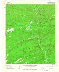
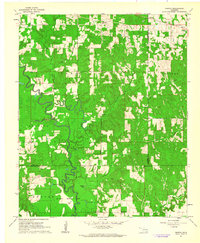 1961 Darwin1963 Print · USGSSoutheastern Oklahoma’s river bottoms and timberlands are captured here in the early sixties as small farming communities thrived. Local researchers can map the grounds of the Mc Leod Honor Farm or find family roots near Darwin Ch and Old Farris.2 unique versions available
 - 1961 Map of Antlers East, 1963 Print
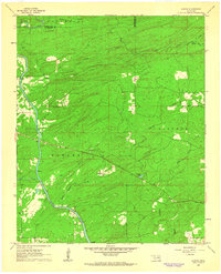
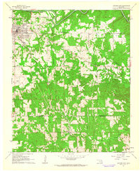 1961 Antlers East1963 Print · USGSAntlers and the rural southeast Oklahoma countryside are captured here in the early sixties, showing the area's transition from town to timberland. Genealogists and local historians can trace family locations near Hamden, Dela, and the Odd Fellows Cem.2 unique versions available
 - 1961 Map of Antlers West, 1963 Print
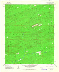
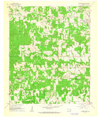 1961 Antlers West1963 Print · USGSPushmataha County is captured here in the early sixties, showing the rural landscape around the town of Antlers. Genealogists and historians can trace local landmarks like Edwards Cem or follow the ST LOUIS SAN FRANCISCO rail line.2 unique versions available
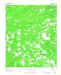
 - 1962 Map of McAlester
 1962 McAlester1962 Print · USGSSoutheastern Oklahoma and western Arkansas are shown here during the early sixties, a time of transition for the region's mountain communities and timberlands. Researchers can trace the paths of the Kansas City Southern RR through Heavener or locate settlements like Talihina and Broken Bow near the Kiamichi Mountains.2 unique versions available
 - 1962 Map of Sobol, 1964 Print
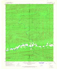
 1962 Sobol1964 Print · USGSThe Kiamichi Mountains and the Little River valley are captured here in the early sixties as rural Oklahoma life centered on small settlements and timber. Trace family roots at Ringold Cem and Sobol Cem, or locate landmarks like the Sobol Lookout Tower.3 unique versions available
 - 1962 Map of Caney Mountain, 1964 Print
 1962 Caney Mountain1964 Print · USGSPushmataha County's mountainous interior was defined by the winding Little River and remote ridges during the early sixties. Genealogists and local historians can trace legacy landmarks like East Cloudy Sch, Caney Creek Sch, and the Billy Bell Trail.3 unique versions available
 - 1962 Map of Alikchi, 1964 Print
 1962 Alikchi1964 Print · USGSMcCurtain and Pushmataha counties are documented here in the early sixties, showing a landscape shaped by the winding Little River. Researchers can locate the Wilson Chapel Cem, the settlement of Ringold, and natural landmarks like Alikchi Spring and Tucker Lake.3 unique versions available
 - 1962 Map of Signal Mountain, 1964 Print
 1962 Signal Mountain1964 Print · USGSThe peaks of the Oklahoma highlands are captured here in the early sixties, showing a wilderness landscape before modern development. Researchers can trace the winding Harry Rowe Trail, the Signal Mountain Lookout Tower, and the remote Brannon Ranch.3 unique versions available
 - 1965 Map of McAlester
 1965 McAlester1965 Print · USGSSoutheastern Oklahoma and western Arkansas appear here in the mid-1960s, showing the intersection of the timber industry and the growing reservoir system. Genealogists can trace family roots through settlements like Antlers, Idabel, and Kiowa or follow the historic routes of the Kansas City Southern Ry.3 unique versions available
 - 1966 Map of Honobia, 1967 Print
 1966 Honobia1967 Print · USGSHonobia sits at the crossroads of several mountain ranges in the mid-1960s, where the winding Little River cuts through the valley. Researchers can find the old Honobia School, trace the Indian Highway, and locate the Spring Hill Church.2 unique versions available
 - 1966 Map of Whitesboro, 1967 Print
 1966 Whitesboro1967 Print · USGSSoutheastern Oklahoma during the mid-sixties reveals a river valley landscape shaped by the timber industry and forest recreation. Genealogists and historians can locate Whitesboro, several country churches like Wadesville Ch, and old Charcoal Ovens.2 unique versions available
End of results
Showing maps 1-11 of 11
Top cities of Pushmataha County
Frequently asked questions
- What are the different types of historical maps available for Pushmataha County?
- What is the oldest map of Pushmataha County?
- Where can I purchase historical maps of Pushmataha County for my home or office?
- Where can I download high-res historical maps of Pushmataha County?
- Are there historical topographic maps available for Pushmataha County?
- Is there historical aerial imagery available for Pushmataha County?
- Where are historical maps of Pushmataha County sourced from?