1970s Maps of Tillman County, Oklahoma
Explore 10 historic maps of Tillman County from the 1970s. These maps offer a rare glimpse into what life looked like during the 1970s — showing old roads, neighborhoods, homes, and landmarks that have changed or disappeared over time.
Whether you're researching your family's past, planning a metal detecting trip, or studying how Tillman County's landscape evolved across the 1970s, these high-resolution maps are a powerful tool for exploring the history of this region.
- Focus on a specific era: All maps on this page are from the 1970s, giving you a focused view of this time period.
- See what’s changed: Compare century-old streets, trails, and buildings to today's modern landscape using overlays and satellite layers.
- Research with precision: Use these maps for genealogy, historical research, land use analysis, or educational projects.
- View, download, or print: Maps are fully viewable online in high resolution, and can be downloaded or printed for your own records.
Start exploring Tillman County's history through authentic maps from the 1970s. This is your window into the past.
Tillman County, OK maps
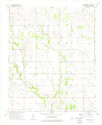
(10)- 1972 Map of Clara, 1975 Print
 1972 Clara1975 Print · USGSWichita County was defined by its petroleum landscape in the 1970s, characterized by expansive energy infrastructure and small rural hubs. Researchers can trace the layout of the Clara Oil Field, locate the Clara Cem, and follow the path of Tenth Cavalry Creek.
 - 1972 Map of Sunshine Hill, 1975 Print
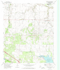 1972 Sunshine Hill1975 Print · USGSThe oil-rich corridor of northern Wichita County comes to life in the early seventies, where petroleum production meets the Red River border. Trace the industrial footprint of the Oil Field and the rail operations at Fowlkes near the Sunshine Hill summit.
 - 1974 Map of Hollister NW, 1977 Print
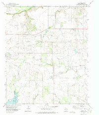
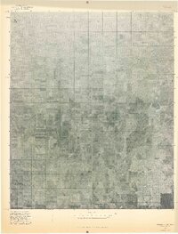
 1974 Hollister NW1977 Print · USGSTillman County was defined by its creeks and rail lines in the mid-1970s before modern expansion changed the rural landscape. Trace the St Louis-San Francisco railroad and find family history at Bethel Cem or the local Gravel Pit.
 - 1974 Map of Hackberry Flat, 1977 Print
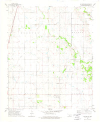
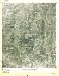
 1974 Hackberry Flat1977 Print · USGSTillman County in the mid-1970s shows a landscape shaped by petroleum and rail transport. Genealogists and local historians can locate Hackberry Cem, Dunkard Cem, and the Missouri-Kansas-Texas rail line.
 - 1974 Map of Hollister, 1977 Print
 1974 Hollister1977 Print · USGSTillman County's agricultural heartland is captured in the mid-seventies, showing the rail-dependent layout of the plains. Trace family ties at Hollister Cem and Loveland Cem, or follow the path of the Missouri-Kansas-Texas railroad.
 - 1974 Map of Hollister NE, 1977 Print
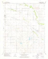
 1974 Hollister NE1977 Print · USGSTillman County was a quiet landscape of agricultural sections and winding drainage basins in the mid-1970s. Local researchers can locate Dickerson Cem and trace the paths of Deep Red Creek and Horse Creek through the terrain.
 - 1975 Map of Frederick NE
 1975 Frederick NE1975 Print · USGSThe Oklahoma plains near the Texas border come into focus in this mid-seventies aerial survey. Local historians and researchers can trace the detailed street grid of Frederick or locate the rural Tipton Cem amidst the region's expansive agricultural fields.
 - 1975 Map of Frederick SW
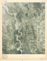 1975 Frederick SW1975 Print · USGSThe Oklahoma-Texas borderlands are captured in high-detail aerial imagery during the mid-1970s, showcasing the vast agricultural grid meeting the river's edge. Researchers can trace the winding, braided course of the North Fork Red River as it carves through the local landscape.
 - 1975 Map of Frederick NW
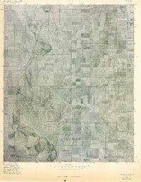 1975 Frederick NW1975 Print · USGSOklahoma's agricultural heartland is documented in the mid-seventies, showing the intersection of the North Fork Red River and the grid of Tipton. Researchers can trace land use patterns near TIPTON and locate the natural waters of WHITE LAKE.
 - 1975 Map of Frederick SE
 1975 Frederick SE1975 Print · USGSSouthwestern Oklahoma's agricultural heartland appears in sharp aerial detail during the mid-seventies, showing the precise layout of Tillman County farms. Researchers can trace the path of Suttle Creek or examine the infrastructure of the Frederick Municipal Airport.
End of results
Showing maps 1-10 of 10
Top cities of Tillman County
- Frederick historical maps
- Grandfield historical maps
- Tipton historical maps
- Davidson historical maps
- Manitou historical maps
- Hollister historical maps
See more
Frequently asked questions
- What are the different types of historical maps available for Tillman County?
- What is the oldest map of Tillman County?
- Where can I purchase historical maps of Tillman County for my home or office?
- Where can I download high-res historical maps of Tillman County?
- Are there historical topographic maps available for Tillman County?
- Is there historical aerial imagery available for Tillman County?
- Where are historical maps of Tillman County sourced from?