1980s Maps of Tillman County, Oklahoma
Explore 17 historic maps of Tillman County from the 1980s. These maps offer a rare glimpse into what life looked like during the 1980s — showing old roads, neighborhoods, homes, and landmarks that have changed or disappeared over time.
Whether you're researching your family's past, planning a metal detecting trip, or studying how Tillman County's landscape evolved across the 1980s, these high-resolution maps are a powerful tool for exploring the history of this region.
- Focus on a specific era: All maps on this page are from the 1980s, giving you a focused view of this time period.
- See what’s changed: Compare century-old streets, trails, and buildings to today's modern landscape using overlays and satellite layers.
- Research with precision: Use these maps for genealogy, historical research, land use analysis, or educational projects.
- View, download, or print: Maps are fully viewable online in high resolution, and can be downloaded or printed for your own records.
Start exploring Tillman County's history through authentic maps from the 1980s. This is your window into the past.
Tillman County, OK maps
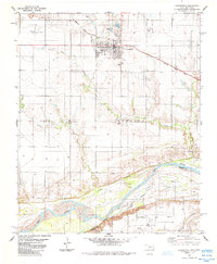
(17)- 1981 Map of Lawton
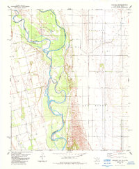
 1981 Lawton1981 Print · USGSSouthwestern Oklahoma in the early eighties shows a landscape shaped by military history and the rising peaks of the Wichitas. Researchers can trace the boundaries of the Fort Sill Military Reservation and locate early settlements like Meers, Chattanooga, and Richards Spur.
 - 1984 Map of Frederick SE, 1985 Print
 1984 Frederick SE1985 Print · USGSTillman County in the mid-1980s reveals a landscape of petroleum production and rail transport along the Red River border. Researchers can locate the Davidson Cemetery and follow the Burlington Northern line as it passes an Oil Field.
 - 1984 Map of Cowboy Springs, 1985 Print
 1984 Cowboy Springs1985 Print · USGSThe Red River borderlands of Tillman County are captured here in the early eighties, showcasing the shifting riverbed and rural industry. Genealogists and historians can trace the Indefinite Boundary and find local sites like Suttle, Cowboy Springs, and various oil wells.
 - 1984 Map of White Lake, 1985 Print
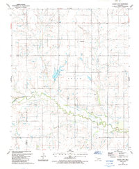
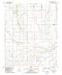
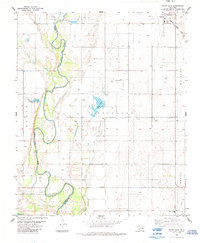 1984 White Lake1985 Print · USGSTipton and the surrounding Oklahoma plains are captured here in the mid-1980s, revealing a landscape of river-bend agriculture and early oil exploration. Genealogists and local historians can trace family land near Weaver Sch or follow the Missouri - Kansas - Texas rail line.
 - 1984 Map of Frederick, 1985 Print
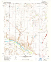
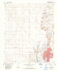 1984 Frederick1985 Print · USGSThe rail-driven hub of Frederick is captured here during the mid-eighties, showing the town's full street grid and civic layout. Local historians can trace the paths of the Missouri Kansas Texas railroad and locate the Frederick Cem or Central Sch.
 - 1984 Map of Frederick SW, 1985 Print
 1984 Frederick SW1985 Print · USGSThe Oklahoma-Texas borderlands come into focus in the early eighties, where the Red River meanders through Tillman and Jackson counties. Researchers can trace the Indefinite Boundary and locate numerous family or industrial Wells and an Oil Well across the Richland landscape.
 - 1985 Map of Oklaunion
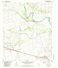 1985 Oklaunion1985 Print · USGSWilbarger County, Texas, and Tillman County, Oklahoma, meet along the river-carved border in the mid-eighties. Trace the local rail-and-water economy through features like the Burlington Northern line, the town of Oklaunion, and Eastview Memorial Cemetery.
 - 1985 Map of Davidson
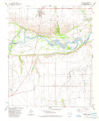 1985 Davidson1985 Print · USGSThe Oklahoma-Texas borderlands in the mid-1980s are defined by the shifting sands of the Red River and the rural hub of Davidson. Genealogists and historians can trace the Burlington Northern rail corridor and find local landmarks like Immanuel Ch and the settlement of Elliott.
 - 1985 Map of Augur Creek
 1985 Augur Creek1985 Print · USGSThe Red River valley along the Oklahoma-Texas border is captured here in the mid-1980s, showing the intersection of river life and prairie agriculture. Researchers can locate the historic Fort Augur (Site) and trace the drainage of Augur Creek and China Creek as they meet the Red River.
 - 1985 Map of Altus
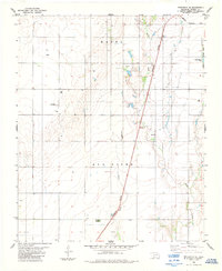
 1985 Altus1985 Print · USGSSouthwestern Oklahoma in the mid-eighties shows a vast agricultural and military landscape shaped by the Red River forks. Trace the intersections of the Atchison Topeka and Santa Fe railroad with rural points like Fairmount Cem and Duke.2 unique versions available
 - 1985 Map of Grandfield
 1985 Grandfield1985 Print · USGSGrandfield and the Tillman County borderlands are shown in the mid-1980s, where the railroad and oil economy meet the Red River. Researchers can trace the path of the Missouri Kansas Texas line or locate family sites near the Cem and Northwest Oil Field.
 - 1985 Map of Devol
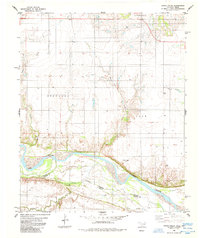
 1985 Devol1985 Print · USGSThe Oklahoma-Texas borderlands come into focus in the mid-1980s, centered on the railroad town of Devol. Researchers can trace the path of the Missouri Kansas Texas line or locate rural Oil Wells and the local Cem.
 - 1985 Map of Burkburnett, 1986 Print
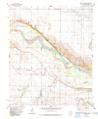
 1985 Burkburnett1986 Print · USGSThe Red River valley and North Texas oil fields are captured here in the mid-eighties, showing the vital connection between military hubs and rail towns. Researchers can trace the path of the Missouri Kansas Texas railroad through Burkburnett or locate Waurika Lake and Sheppard Air Force Base.2 unique versions available
 - 1986 Map of Vernon
 1986 Vernon1986 Print · USGSNorth Texas and Southern Oklahoma meet along the river in the mid-1980s, revealing a landscape defined by ranching, oil production, and rail transport. Researchers can locate distinct landmarks such as Medicine Mound, the Conley Oil Field, and the community of Punkin Center.
 - 1987 Map of Whites Lake
 1987 Whites Lake1987 Print · USGSSouthern Oklahoma during the late 1980s reveals a rural landscape shaped by the winding course of Deep Red Creek. Local researchers can trace the vicinity of Ahpeatone Ch and identify water features like Whites Lake and the nearby Levee.
 - 1987 Map of Chattanooga
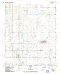 1987 Chattanooga1987 Print · USGSThe rural prairie of Comanche and Tillman counties is captured here in the late 1980s. Researchers can locate the Chattanooga Cem and trace water-dependent landmarks like Kinder Lake or the numerous Gravel Pits dotting the landscape.
 - 1987 Map of Chattanooga SW, 1988 Print
 1987 Chattanooga SW1988 Print · USGSTillman and Cotton counties are shown in the late eighties as a landscape of rural townships and winding creeks. Genealogists and historians can trace the Missouri-Kansas-Texas rail line near Loveland or locate Chattanooga Sky Harbor.
End of results
Showing maps 1-17 of 17
Top cities of Tillman County
- Frederick historical maps
- Grandfield historical maps
- Tipton historical maps
- Davidson historical maps
- Manitou historical maps
- Hollister historical maps
See more
Frequently asked questions
- What are the different types of historical maps available for Tillman County?
- What is the oldest map of Tillman County?
- Where can I purchase historical maps of Tillman County for my home or office?
- Where can I download high-res historical maps of Tillman County?
- Are there historical topographic maps available for Tillman County?
- Is there historical aerial imagery available for Tillman County?
- Where are historical maps of Tillman County sourced from?