1960s Maps of Tillman County, Oklahoma
Explore 4 historic maps of Tillman County from the 1960s. These maps offer a rare glimpse into what life looked like during the 1960s — showing old roads, neighborhoods, homes, and landmarks that have changed or disappeared over time.
Whether you're researching your family's past, planning a metal detecting trip, or studying how Tillman County's landscape evolved across the 1960s, these high-resolution maps are a powerful tool for exploring the history of this region.
- Focus on a specific era: All maps on this page are from the 1960s, giving you a focused view of this time period.
- See what’s changed: Compare century-old streets, trails, and buildings to today's modern landscape using overlays and satellite layers.
- Research with precision: Use these maps for genealogy, historical research, land use analysis, or educational projects.
- View, download, or print: Maps are fully viewable online in high resolution, and can be downloaded or printed for your own records.
Start exploring Tillman County's history through authentic maps from the 1960s. This is your window into the past.
Tillman County, OK maps
(4)- 1962 Map of Chattanooga, 1964 Print
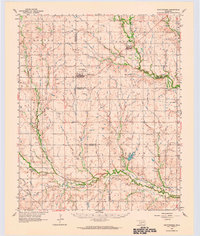 1962 Chattanooga1964 Print · USGSThe rural plains of Comanche and Tillman counties are captured here in the early 1960s. Genealogists and local historians can trace the foundations of Faxon and Chattanooga, along with landmarks like Ahpeatone Sch, Bible Ch, and the Chattanooga Cem.
 - 1964 Map of Tipton SE, 1965 Print
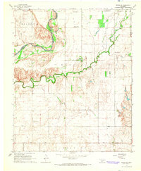 1964 Tipton SE1965 Print · USGSTillman County and the Red River forks are mapped here during the mid-sixties, capturing the rural community life of the Oklahoma plains. Genealogists and researchers can locate the Center View Cem, Mt Gillian Ch, and the Pleasant Valley Ch.2 unique versions available
 - 1964 Map of Tipton, 1965 Print
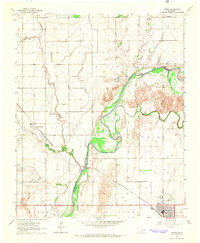 1964 Tipton1965 Print · USGSOklahoma's southwestern plains come into focus in the mid-sixties, dominated by the winding course of the North Fork Red River. Genealogists and historians can trace the rail-side growth of Tipton, the Boucher Oil Field, and the site of a local Orphanage.2 unique versions available
 - 1964 Map of Long Mountain, 1965 Print
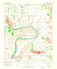 1964 Long Mountain1965 Print · USGSSouthwestern Oklahoma's river valley and granite peaks are meticulously captured during the mid-1960s. Genealogists and historians can trace the paths of the St Louis - San Francisco railroad and locate rural landmarks like Headrick Cem and Centerville.2 unique versions available
End of results
Showing maps 1-4 of 4
Top cities of Tillman County
- Frederick historical maps
- Grandfield historical maps
- Tipton historical maps
- Davidson historical maps
- Manitou historical maps
- Hollister historical maps
See more
Frequently asked questions
- What are the different types of historical maps available for Tillman County?
- What is the oldest map of Tillman County?
- Where can I purchase historical maps of Tillman County for my home or office?
- Where can I download high-res historical maps of Tillman County?
- Are there historical topographic maps available for Tillman County?
- Is there historical aerial imagery available for Tillman County?
- Where are historical maps of Tillman County sourced from?