1910s Maps of South Carolina
Explore 31 historic maps of South Carolina from the 1910s. These maps offer a rare glimpse into what life looked like during the 1910s — showing old roads, neighborhoods, homes, and landmarks that have changed or disappeared over time.
Whether you're researching your family's past, planning a metal detecting trip, or studying how South Carolina's landscape evolved across the 1910s, these high-resolution maps are a powerful tool for exploring the history of this region.
- Focus on a specific era: All maps on this page are from the 1910s, giving you a focused view of this time period.
- See what’s changed: Compare century-old streets, trails, and buildings to today's modern landscape using overlays and satellite layers.
- Research with precision: Use these maps for genealogy, historical research, land use analysis, or educational projects.
- View, download, or print: Maps are fully viewable online in high resolution, and can be downloaded or printed for your own records.
Start exploring South Carolina's history through authentic maps from the 1910s. This is your window into the past.
South Carolina maps
(31)- 1912 Map of Mc Cormick, 1913 Print
 1912 Mc Cormick1913 Print · USGSThe Georgia and South Carolina borderlands come alive in the 1890s, centered on the rail junction at Mc Cormick and the Savannah River. Genealogists can trace family footprints across numerous river crossings like Fury Ferry and through rural centers such as Appling and Sharon Church.
 - 1918 Map of Walterboro
 1918 Walterboro1918 Print · USGSColleton County at the end of the Great War reveals a landscape of river-centered commerce and scattered rural settlements. Family historians can trace ancestral locations through the many churches and schools, such as Catholic Hill, Evergreen Church, and Koger School.4 unique versions available
 - 1918 Map of Kiawah Island
 1918 Kiawah Island1918 Print · USGSCoastal South Carolina remains a wilderness of woods and brush during the Great War era. Researchers can trace the early layout of Kiawah Island, identifying landmarks like Avenue Road, Eagle Point, and the eastern tip at Sandy Point.2 unique versions available
 - 1918 Map of Green Pond
 1918 Green Pond1918 Print · USGSThe South Carolina Lowcountry is captured here just as the First World War ended, showing a landscape defined by the winding Combahee and Ashepoo rivers. Researchers can trace historic family routes along the Old Savannah and Charleston Road and locate rural landmarks like Combahee Ferry and First African Church.4 unique versions available
 - 1918 Map of Varnville
 1918 Varnville1918 Print · USGSCoastal South Carolina is depicted just after the Great War, showing a network of rail-dependent towns and timber operations. Genealogists can trace family roots through numerous local landmarks like Prince William Church, Hampton, and Harrison Sawmill.4 unique versions available
 - 1918 Map of Yemassee
 1918 Yemassee1918 Print · USGSCoastal South Carolina at the end of the Great War reveals a landscape of tidal rivers and emerging rail junctions. Genealogists can trace family locations across Grahams Neck or near historic sites like Pocotaligo, Sheldon, and the logging camps around Gilmania.4 unique versions available
 - 1918 Map of Cottageville
 1918 Cottageville1918 Print · USGSThe Lowcountry river basins of Colleton and Dorchester counties are shown here just after the Great War, when the Edisto River was a central geographic divider. Researchers can trace rural life through dozens of named landmarks like Sullivans Church, Metz Store, and Burnt Church Crossroads.3 unique versions available
 - 1919 Map of Ladson
 1919 Ladson1919 Print · USGSThe South Carolina lowcountry is captured here just after the Great War, showing a landscape of riverfront estates and rail-connected settlements. Researchers can trace the grounds of Magnolia Gardens or locate rural centers like Ladson and Otranto.2 unique versions available
 - 1919 Map of Johns Island
 1919 Johns Island1919 Print · USGSCoastal South Carolina at the end of the Great War reveals a landscape of riverfront estates and military remnants. Genealogists and historians can trace family-named stops and rural institutions like Drayton Hall, St Andrews School No 10, and the Bula Mines.2 unique versions available
 - 1919 Map of Summerville
 1919 Summerville1919 Print · USGSSummerville and the surrounding Lowcountry wetlands are captured here just after the Great War, during a period of established rail reliance and rural growth. Genealogists and researchers can trace local landmarks like St Johns Church, the Clemson Coast Express Station, and numerous early school sites including Barrow School.
 - 1919 Map of Pineland
 1919 Pineland1919 Print · USGSThe Lowcountry landscape of Jasper and Hampton counties is captured here at the end of the post-war era, showing a transition between rail-centered towns and timber-rich wetlands. Genealogists can locate family ties at Highsmith's Sawmill, Good Hope Church, and the Pineland Club.3 unique versions available
 - 1919 Map of Edisto Island
 1919 Edisto Island1919 Print · USGSThe South Carolina Lowcountry is depicted here in the years following the Great War, showing a coastal landscape of tidal creeks and island communities. You can trace early 20th-century life through landmarks like Freedman Village, Borough School, and the Old Public Landing.3 unique versions available
 - 1919 Map of Olar
 1919 Olar1919 Print · USGSBamberg and Barnwell counties are shown here just after the Great War, when the river swamps still dictated the path of travel. Genealogists can locate family sites near Hushes Old Mill, Savannah Creek Church, and Stony Bay School.3 unique versions available
 - 1919 Map of The Jetties
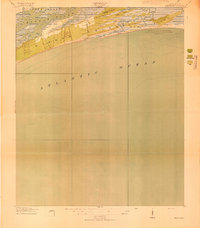
 1919 The Jetties1919 Print · USGSCoastal Charleston and the harbor entrance appear in this military-led survey from the era following the First World War. Maritime historians can trace the engineering of the North Jetty and South Jetty alongside the northern reaches of Morris Island.4 unique versions available
 - 1919 Map of Capers Island
 1919 Capers Island1919 Print · USGSThe barrier islands of Charleston County are shown in fine detail in the years following the Great War. You can trace early 20th-century shorelines and tidal paths through Copahee Sound and locate landmarks like Videl Landing and Alligator Pond.2 unique versions available
 - 1919 Map of Ridgeville
 1919 Ridgeville1919 Print · USGSCoastal South Carolina at the end of the Great War era reveals a landscape of dense swamps and rail-side settlements. Genealogists can trace family roots through numerous local landmarks like Cypress Camp Meeting Grounds, Mudville School, and Limestone Church.
 - 1919 Map of Wadmelaw Island
 1919 Wadmelaw Island1919 Print · USGSCoastal South Carolina is mapped here just after the Great War, showing a landscape of sea island plantations and tidal waterways. Researchers can locate remote settlements like Rockville and Legareville, as well as rural landmarks like Crate Mill and St Johns Church.2 unique versions available
 - 1919 Map of Shirley
 1919 Shirley1919 Print · USGSThe Savannah River borderlands in the years following the Great War reveal a landscape of active river landings, logging railroads, and tight-knit rural communities. You can trace early 20th-century family roots at Heavenly Rest Ch, Cypressvale School, and the busy Hudsons Ferry Landing.3 unique versions available
 - 1919 Map of Wando
 1919 Wando1919 Print · USGSCoastal Berkeley and Charleston Counties come alive in this survey from just after the Great War. Genealogists can locate family landmarks like St Matthews Church, trace the winding Lumber R. R., or find old river access at Lachicotte Landing.5 unique versions available
 - 1919 Map of Cordesville
 1919 Cordesville1919 Print · USGSBerkeley County was a landscape of dense swamps and historic parish chapels just after the First World War. Genealogists can trace family roots through numerous sites like Strawberry Chapel, Bethera Church, and the rural Pine Grove Flag Station.2 unique versions available
 - 1919 Map of Melgrove
 1919 Melgrove1919 Print · USGSThe South Carolina lowcountry emerges in detail during the post-WWI era as industry begins to touch the Cooper River. Genealogists can trace early neighborhood footprints in North Charleston or locate rural landmarks like St.Johns Church and Redbank Landing.3 unique versions available
 - 1919 Map of Charleston
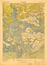
 1919 Charleston1919 Print · USGSCoastal South Carolina thrives at the height of its naval and rail importance in the years following the Great War. Genealogists and historians can trace the development of the Navy Yard and local landmarks like Castle Pinckney and Magnolia Cem.3 unique versions available
 - 1919 Map of James Island
 1919 James Island1919 Print · USGSThe marshlands and small coastal communities of James Island are documented here at the end of the Great War. Genealogists and historians can trace old homesteads and roads through Centerville, find the Payne Chapel, and locate maritime landmarks like the Charleston LH.2 unique versions available
 - 1919 Map of Fort Moultrie
 1919 Fort Moultrie1919 Print · USGSThe Charleston coast at the end of the Great War reveals a landscape of strategic coastal fortifications and early island settlements. Genealogists and historians can trace the layouts of Moultrieville, Mt Pleasant, and the grounds of Fort Moultrie.3 unique versions available
 - 1919 Map of Bamberg
 1919 Bamberg1919 Print · USGSThe South Carolina Lowcountry is captured here in the aftermath of the Great War, showing a landscape defined by rail junctions and river landings. Genealogists can trace family roots through numerous rural landmarks like Vorhees Institute, Spires Chapel, and Opossum College.
Showing maps 1-25 of 31
Top cities of South Carolina
- Charleston historical maps
- Columbia historical maps
- North Charleston historical maps
- Rock Hill historical maps
- Greenville historical maps
- Mount Pleasant historical maps
See more
Top counties of South Carolina
- Greenville County historical maps
- Richland County historical maps
- Charleston County historical maps
- Horry County historical maps
- Spartanburg County historical maps
- Lexington County historical maps
See more
Frequently asked questions
- What are the different types of historical maps available for South Carolina?
- What is the oldest map of South Carolina?
- Where can I purchase historical maps of South Carolina for my home or office?
- Where can I download high-res historical maps of South Carolina?
- Are there historical topographic maps available for South Carolina?
- Is there historical aerial imagery available for South Carolina?
- Where are historical maps of South Carolina sourced from?