1900s (20th Century) Maps of South Carolina
Explore 968 historic maps of South Carolina from the 1900s (20th Century). These maps offer a rare glimpse into what life looked like during the 1900s — showing old roads, neighborhoods, homes, and landmarks that have changed or disappeared over time.
Whether you're researching your family's past, planning a metal detecting trip, or studying how South Carolina's landscape evolved across the 1900s, these high-resolution maps are a powerful tool for exploring the history of this region.
- Focus on a specific era: All maps on this page are from the 1900s, giving you a focused view of this time period.
- See what’s changed: Compare century-old streets, trails, and buildings to today's modern landscape using overlays and satellite layers.
- Research with precision: Use these maps for genealogy, historical research, land use analysis, or educational projects.
- View, download, or print: Maps are fully viewable online in high resolution, and can be downloaded or printed for your own records.
Start exploring South Carolina's history through authentic maps from the 1900s. This is your window into the past.
South Carolina maps
(968)- 1904 Map of Columbia
 1904 Columbia1904 Print · USGSRichland and Fairfield counties at the turn of the century are defined by their river-and-rail corridors and rural church communities. Genealogists can trace family footprints across Broad River ferries, the Southern R.R., and landmarks like The Old Brick Church or Winnsboro.2 unique versions available
 - 1905 Map of Charlotte
 1905 Charlotte1905 Print · USGSMecklenburg County at the start of the twentieth century shows a region connected by the early Southern Railway and a burgeoning city center. Genealogists can trace family roots through numerous rural landmarks like McClintock Church, Pineville, and Shopton.2 unique versions available
 - 1905 Map of Pisgah, 1956 Print
 1905 Pisgah1956 Print · USGSThe North Carolina high country around the turn of the century reveals a land of timber tracts and emerging mountain retreats. Genealogists and hikers can trace early routes to Buck Spring Lodge, follow the Southern RR tracks, and locate vanished settlements like Angeline and Calhoun.
 - 1906 Map of Crawfordville
 1906 Crawfordville1906 Print · USGSUpper Georgia and the South Carolina border come alive in this early century survey, showing a landscape defined by river ferries and mining sites. Genealogists can trace family roots through old post offices like Triplett P.O. or find historic crossings like Fishdam Ferry and the Columbia Mines.3 unique versions available
 - 1906 Map of Pisgah, 1934 Print
 1906 Pisgah1934 Print · USGSThe Blue Ridge highlands at the turn of the century reveal a landscape of mountain river valleys and early timber frontiers. Genealogists and historians can trace family-named bridges and crossings like Graham Bridge or locate vanished settlements such as Grange and Retreat.2 unique versions available
 - 1906 Map of Kings Mountain, 1970 Print
 1906 Kings Mountain1970 Print · USGSThe North and South Carolina borderlands come alive in this early century survey of the Kings Mountain vicinity. Genealogists can locate family landmarks including Lincoln Academy, Bordens Ferry, and Pleasant Hill Church.
 - 1907 Map of Sharon
 1907 Sharon1907 Print · USGSUpstate South Carolina at the turn of the century shows a region deeply connected by river ferries and new rail lines. Genealogists can trace early homesteads near Sharon, Hickory Grove, and the historic Pinckney Ferry on the Broad River.3 unique versions available
 - 1907 Map of Saluda
 1907 Saluda1907 Print · USGSNorth Carolina's mountain frontier meets the South Carolina foothills in this 1900s survey of the Blue Ridge. Genealogists and researchers can trace the early rail network through Saluda and locate old landmarks like Rockcliff PO and Pleasant Grove Church.3 unique versions available
 - 1907 Map of Cowee
 1907 Cowee1907 Print · USGSWestern North Carolina at the turn of the century shows a landscape of rail-connected river towns and high mountain gaps. Genealogists can trace early homesteads and industry through landmarks like West Mill, Roanes Mill, and the many settlements along the Southern Railway.5 unique versions available
 - 1907 Map of Charlotte
 1907 Charlotte1907 Print · USGSGreater Charlotte was a bustling rail and textile corridor at the dawn of the twentieth century, bridging the two Carolinas. Genealogists can locate old family landmarks like Sutton School and Steel Creek Church or trace the early growth of Dilworth.4 unique versions available
 - 1908 Map of Kings Mountain
 1908 Kings Mountain1908 Print · USGSThe Carolina borderlands come alive in the first decade of the 1900s, centered on the landmark Kings Mountain Battleground and its namesake ridge. Genealogists can trace family roots through numerous rural churches and schools, including Ramah Church, Beersheba Church, and the Lincoln Academy.6 unique versions available
 - 1908 Map of Kirksey, 1942 Print
 1908 Kirksey1942 Print · USGSMid-century Greenwood County is captured here during a time when rural schoolhouses and small settlements like Phoenix and Kirksey still anchored local life. Researchers can trace the Georgia and Florida railroad and find defunct local schools like Brick House Sch or Sand Ridge Sch.
 - 1909 Map of Gaffney
 1909 Gaffney1909 Print · USGSCherokee County at the turn of the century centers on the growing textile and rail hubs of Gaffney and Blacksburg. Researchers can trace early river transport at Stacy Ferry or locate ancestral roots at Providence Church and the Sarratt School.4 unique versions available
 - 1912 Map of Mc Cormick, 1913 Print
 1912 Mc Cormick1913 Print · USGSThe Georgia and South Carolina borderlands come alive in the 1890s, centered on the rail junction at Mc Cormick and the Savannah River. Genealogists can trace family footprints across numerous river crossings like Fury Ferry and through rural centers such as Appling and Sharon Church.
 - 1918 Map of Walterboro
 1918 Walterboro1918 Print · USGSColleton County at the end of the Great War reveals a landscape of river-centered commerce and scattered rural settlements. Family historians can trace ancestral locations through the many churches and schools, such as Catholic Hill, Evergreen Church, and Koger School.4 unique versions available
 - 1918 Map of Kiawah Island
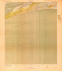 1918 Kiawah Island1918 Print · USGSCoastal South Carolina remains a wilderness of woods and brush during the Great War era. Researchers can trace the early layout of Kiawah Island, identifying landmarks like Avenue Road, Eagle Point, and the eastern tip at Sandy Point.2 unique versions available
 - 1918 Map of Green Pond
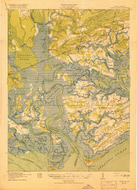
 1918 Green Pond1918 Print · USGSThe South Carolina Lowcountry is captured here just as the First World War ended, showing a landscape defined by the winding Combahee and Ashepoo rivers. Researchers can trace historic family routes along the Old Savannah and Charleston Road and locate rural landmarks like Combahee Ferry and First African Church.4 unique versions available
 - 1918 Map of Varnville
 1918 Varnville1918 Print · USGSCoastal South Carolina is depicted just after the Great War, showing a network of rail-dependent towns and timber operations. Genealogists can trace family roots through numerous local landmarks like Prince William Church, Hampton, and Harrison Sawmill.4 unique versions available
 - 1918 Map of Yemassee
 1918 Yemassee1918 Print · USGSCoastal South Carolina at the end of the Great War reveals a landscape of tidal rivers and emerging rail junctions. Genealogists can trace family locations across Grahams Neck or near historic sites like Pocotaligo, Sheldon, and the logging camps around Gilmania.4 unique versions available
 - 1918 Map of Cottageville
 1918 Cottageville1918 Print · USGSThe Lowcountry river basins of Colleton and Dorchester counties are shown here just after the Great War, when the Edisto River was a central geographic divider. Researchers can trace rural life through dozens of named landmarks like Sullivans Church, Metz Store, and Burnt Church Crossroads.3 unique versions available
 - 1919 Map of Ladson
 1919 Ladson1919 Print · USGSThe South Carolina lowcountry is captured here just after the Great War, showing a landscape of riverfront estates and rail-connected settlements. Researchers can trace the grounds of Magnolia Gardens or locate rural centers like Ladson and Otranto.2 unique versions available
 - 1919 Map of Johns Island
 1919 Johns Island1919 Print · USGSCoastal South Carolina at the end of the Great War reveals a landscape of riverfront estates and military remnants. Genealogists and historians can trace family-named stops and rural institutions like Drayton Hall, St Andrews School No 10, and the Bula Mines.2 unique versions available
 - 1919 Map of Summerville
 1919 Summerville1919 Print · USGSSummerville and the surrounding Lowcountry wetlands are captured here just after the Great War, during a period of established rail reliance and rural growth. Genealogists and researchers can trace local landmarks like St Johns Church, the Clemson Coast Express Station, and numerous early school sites including Barrow School.
 - 1919 Map of Pineland
 1919 Pineland1919 Print · USGSThe Lowcountry landscape of Jasper and Hampton counties is captured here at the end of the post-war era, showing a transition between rail-centered towns and timber-rich wetlands. Genealogists can locate family ties at Highsmith's Sawmill, Good Hope Church, and the Pineland Club.3 unique versions available
 - 1919 Map of Edisto Island
 1919 Edisto Island1919 Print · USGSThe South Carolina Lowcountry is depicted here in the years following the Great War, showing a coastal landscape of tidal creeks and island communities. You can trace early 20th-century life through landmarks like Freedman Village, Borough School, and the Old Public Landing.3 unique versions available
Showing maps 1-25 of 968
Top cities of South Carolina
- Charleston historical maps
- Columbia historical maps
- North Charleston historical maps
- Rock Hill historical maps
- Greenville historical maps
- Mount Pleasant historical maps
See more
Top counties of South Carolina
- Greenville County historical maps
- Richland County historical maps
- Charleston County historical maps
- Horry County historical maps
- Spartanburg County historical maps
- Lexington County historical maps
See more
Frequently asked questions
- What are the different types of historical maps available for South Carolina?
- What is the oldest map of South Carolina?
- Where can I purchase historical maps of South Carolina for my home or office?
- Where can I download high-res historical maps of South Carolina?
- Are there historical topographic maps available for South Carolina?
- Is there historical aerial imagery available for South Carolina?
- Where are historical maps of South Carolina sourced from?