1930s Maps of South Carolina
Explore 18 historic maps of South Carolina from the 1930s. These maps offer a rare glimpse into what life looked like during the 1930s — showing old roads, neighborhoods, homes, and landmarks that have changed or disappeared over time.
Whether you're researching your family's past, planning a metal detecting trip, or studying how South Carolina's landscape evolved across the 1930s, these high-resolution maps are a powerful tool for exploring the history of this region.
- Focus on a specific era: All maps on this page are from the 1930s, giving you a focused view of this time period.
- See what’s changed: Compare century-old streets, trails, and buildings to today's modern landscape using overlays and satellite layers.
- Research with precision: Use these maps for genealogy, historical research, land use analysis, or educational projects.
- View, download, or print: Maps are fully viewable online in high resolution, and can be downloaded or printed for your own records.
Start exploring South Carolina's history through authentic maps from the 1930s. This is your window into the past.
South Carolina maps
(18)- 1935 Map of Brevard
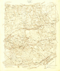
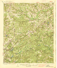
 1935 Brevard1935 Print · USGSBrevard and the French Broad River valley are shown here in the mid-1930s as the region balanced traditional mountain farming with new hydroelectric and recreational development. Genealogists and local historians can trace family-named sites like Breeses Mill, Gillespie Cem, and rural schools including Holden Sch.
 - 1935 Map of Eastatoe Gap
 1935 Eastatoe Gap1935 Print · USGSThe Blue Ridge mountain crest and state borderlands are captured in this mid-1930s survey of the French Broad River headwaters. Genealogists and hikers can trace historic crossings at Eastatoe Gap, locate the Middle Fork Ch, and find the Fire Tower on Sassafras Mtn.
 - 1935 Map of Standingstone Mtn.
 1935 Standingstone Mtn.1935 Print · USGSThe Blue Ridge mountain borderlands are captured here in the mid-1930s as modern utility lines began to cross the wilderness. Genealogists and hikers can trace the original paths to Holly Springs Ch, the waters of Triple Falls, and the high ridges of Standingstone Mtn.
 - 1935 Map of Greer
 1935 Greer1935 Print · USGSThe industrial textile hubs and rural communities of the South Carolina Piedmont thrive along the rail lines during the mid-thirties. Genealogists and local historians can trace family locations near Victor Mills, Hanson Academy, and numerous country churches like Woods Chapel.
 - 1935 Map of Cashiers
 1935 Cashiers1935 Print · USGSJackson County and the North Carolina-South Carolina border appear here in the mid-1930s as modern surveying techniques were first being applied. Researchers can trace early state infrastructure such as St Hy No 106 as it passes through the Nantahala National Forest.
 - 1935 Map of Reid
 1935 Reid1935 Print · USGSThe high ridges of Transylvania County are captured here in the mid-1930s as federal surveyors first mapped the area using aerial photography. Researchers can trace the early mountain roads like State No 28 near the settlement of Reid and the headwaters of Morton Creek.
 - 1935 Map of Camden
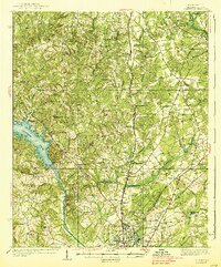
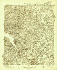 1935 Camden1935 Print · USGSCamden and the Wateree River basin are captured here in the mid-1930s, showing a region balanced between traditional river-powered mills and new infrastructure. Genealogists can trace family footprints near rural landmarks like Rabon Cross Roads, Kirkley Mill, and the Baron de Kalb Sch.2 unique versions available
 - 1935 Map of Greenville
 1935 Greenville1935 Print · USGSGreenville and its surrounding Piedmont communities are shown in detail during the mid-1930s as the textile and rail economy expanded. Researchers can find numerous local landmarks like Chick Springs, the Judson Cemetery, and Travelers Rest.
 - 1935 Map of Table Rock
 1935 Table Rock1935 Print · USGSThe Carolina borderlands and the upper reaches of the French Broad River are captured here in the mid-1930s. Genealogists and researchers can trace family-named watercourses like Bradley Creek and Cantrell Creek near Dunns Rock.
 - 1935 Map of Killian
 1935 Killian1935 Print · USGSRichland County at the height of the mid-1930s is a landscape of rural schoolhouses and growing military infrastructure. Genealogists can trace family landmarks like Kelley Cem, Bookman Mill, and dozens of local churches including Roundtop Ch.2 unique versions available
 - 1935 Map of Zirconia
 1935 Zirconia1935 Print · USGSHenderson County in the mid-1930s is shown here in an early aerial-photograph survey of the high ridge lines. Genealogists and hikers can trace old mountain trails near Mt Olivet Ch, the peaks of McAlpine Mtn, and the community at Gem.
 - 1937 Map of Myrtle Beach
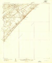 1937 Myrtle Beach1937 Print · USGSThe Grand Strand is seen here in the late 1930s as a developing coastal corridor transitioning from swampy lowlands to a vacation destination. Trace early infrastructure including the Intracoastal Waterway, Myrtle Beach State Park, and the CCC Camp.3 unique versions available
 - 1937 Map of Nixonville
 1937 Nixonville1937 Print · USGSCoastal South Carolina is depicted just before the war as a landscape of river landings and rural schoolhouses. Researchers can locate family landmarks like Graham Cem, identify the location of the Chain Gang Shanty, and trace the path of the Atlantic Coast Line.2 unique versions available
 - 1937 Map of Killian
 1937 Killian1937 Print · USGSRichland and Kershaw counties in the mid-1930s show a landscape of growing military installations and rural community life. Genealogists can trace family names through dozens of landmarks like Bookmans Mill, Sand Level Sch, and Union Baptist Ch.4 unique versions available
 - 1938 Map of Greenville
 1938 Greenville1938 Print · USGSGreenville and its surrounding textile communities thrive in the mid-1930s as a major Piedmont industrial and rail hub. Researchers can locate numerous rural landmarks like the Rosenwald Sch, trace the Southern RR, or find family sites near Saluda Lake.2 unique versions available
 - 1938 Map of Camden
 1938 Camden1938 Print · USGSMid-century Kershaw County comes alive here, showing the river-and-rail economy of the 1930s before modern development altered the landscape. Genealogists can trace family roots at Rabon Crossroads, Westville, and the many rural sites like Knight Hill Sch.2 unique versions available
 - 1938 Map of Greer
 1938 Greer1938 Print · USGSUpstate South Carolina during the mid-1930s was a landscape of bustling textile centers and quiet rural crossroads. Genealogists and historians can trace family roots through numerous local landmarks like Woods Chapel, Jackson Mill, and the CCC Camp near Switzer.3 unique versions available
 - 1938 Map of Hagood
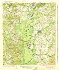 1938 Hagood1938 Print · USGSThe Wateree River basin comes to life in this pre-war study of the Kershaw and Sumter county borderlands. Researchers can trace the river's old crossings and mills at Ancrum Ferry and Boykin Mill Pond, alongside historic schools like Kershaw Industrial Sch.3 unique versions available
End of results
Showing maps 1-18 of 18
Top cities of South Carolina
- Charleston historical maps
- Columbia historical maps
- North Charleston historical maps
- Rock Hill historical maps
- Greenville historical maps
- Mount Pleasant historical maps
See more
Top counties of South Carolina
- Greenville County historical maps
- Richland County historical maps
- Charleston County historical maps
- Horry County historical maps
- Spartanburg County historical maps
- Lexington County historical maps
See more
Frequently asked questions
- What are the different types of historical maps available for South Carolina?
- What is the oldest map of South Carolina?
- Where can I purchase historical maps of South Carolina for my home or office?
- Where can I download high-res historical maps of South Carolina?
- Are there historical topographic maps available for South Carolina?
- Is there historical aerial imagery available for South Carolina?
- Where are historical maps of South Carolina sourced from?