1960s Maps of Butte County, South Dakota
Explore 10 historic maps of Butte County from the 1960s. These maps offer a rare glimpse into what life looked like during the 1960s — showing old roads, neighborhoods, homes, and landmarks that have changed or disappeared over time.
Whether you're researching your family's past, planning a metal detecting trip, or studying how Butte County's landscape evolved across the 1960s, these high-resolution maps are a powerful tool for exploring the history of this region.
- Focus on a specific era: All maps on this page are from the 1960s, giving you a focused view of this time period.
- See what’s changed: Compare century-old streets, trails, and buildings to today's modern landscape using overlays and satellite layers.
- Research with precision: Use these maps for genealogy, historical research, land use analysis, or educational projects.
- View, download, or print: Maps are fully viewable online in high resolution, and can be downloaded or printed for your own records.
Start exploring Butte County's history through authentic maps from the 1960s. This is your window into the past.
Butte County, SD maps
(10)- 1962 Map of Gillette
 1962 Gillette1962 Print · USGSHigh plains ranching and coal mining dominate the Powder River Basin in the early sixties. Genealogists can trace rural communities through landmarks like the Bethlehem Church, Lake School, and settlements such as Moorcroft and Sundance.
 - 1965 Map of Ekalaka
 1965 Ekalaka1965 Print · USGSThe High Plains of Montana and Wyoming appear here in the mid-1950s, as a sprawling landscape of remote ranchlands and rural school districts. Researchers can trace the locations of many small landmarks like Mitchell School, Broadus, and the Humbolt Hills.
 - 1965 Map of Antelope Butte, 1966 Print
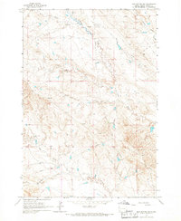
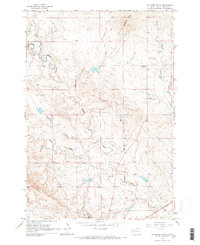 1965 Antelope Butte1966 Print · USGSThe Butte County high plains are captured here in the mid-1960s, showing a landscape of working ranches and remote creek drainages. Researchers can trace the boundaries of the Davis Ranch or Hoeye Ranch and locate the Center of Nation Roadside Park.2 unique versions available
 - 1965 Map of Two Top Butte West, 1967 Print
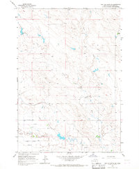
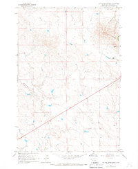 1965 Two Top Butte West1967 Print · USGSButte County ranching country is documented here in the mid-1960s, showing a landscape defined by prominent landforms and prairie drainage. Researchers can locate the Kinghorn Two Top Ranch and trace the paths of Horse Creek and Hilderbrand Creek near the landmark Two Top Butte.
 - 1965 Map of Two Top Butte East, 1967 Print
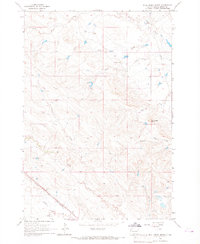
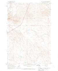 1965 Two Top Butte East1967 Print · USGSButte County ranch lands appear here in the mid-sixties, characterized by open range and precise fence line data. Researchers can trace the meandering paths of Horse Creek and Willow Creek or locate the distinctive high point of Two Top Peak.
 - 1965 Map of Mud Buttes, 1967 Print
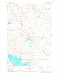
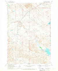 1965 Mud Buttes1967 Print · USGSButte County ranching life is captured here in the mid-sixties as the northern shores of the Belle Fourche Reservoir meet the surrounding plains. Researchers can trace historic family holdings like the Jones Ranch and locate the Owl Creek School.2 unique versions available
 - 1965 Map of Mud Buttes NW, 1967 Print
 1965 Mud Buttes NW1967 Print · USGSButte County ranching country is captured here during the mid-1960s, showing a landscape of family-named holdings and high plains watercourses. Researchers can locate remote landmarks like the Antelope Sch and trace local genealogy through the Gilger Ranch or Mary Larson Ranch.2 unique versions available
 - 1965 Map of Two Top Butte SE, 1967 Print
 1965 Two Top Butte SE1967 Print · USGSButte County ranching and irrigation are captured here in the mid-1960s, showing the vital network of prairie water management. Researchers can trace rural school locations like Kennedy Sch and Winkler Sch or family rangelands such as Persche Ranch.
 - 1965 Map of Arpan, 1967 Print
 1965 Arpan1967 Print · USGSButte County, South Dakota, in the mid-1960s showcases a landscape defined by ranching and the intricate irrigation of the high plains. Researchers can locate the rural Barker Sch, the settlement of Arpan, and the expansive Belle Fourche Reservoir.
 - 1965 Map of Bull Creek Butte, 1967 Print
 1965 Bull Creek Butte1967 Print · USGSButte County ranching and rail transport are captured here in the mid-1960s, showing a landscape shaped by seasonal creeks and the Chicago and North Western line. Trace local family history at Kiplinger Ranch and Taylor Ranch near Bull Creek Butte.
End of results
Showing maps 1-10 of 10
Top cities of Butte County
- Belle Fourche historical maps
- Newell historical maps
- Nisland historical maps
- Vale historical maps
- Fruitdale historical maps
Frequently asked questions
- What are the different types of historical maps available for Butte County?
- What is the oldest map of Butte County?
- Where can I purchase historical maps of Butte County for my home or office?
- Where can I download high-res historical maps of Butte County?
- Are there historical topographic maps available for Butte County?
- Is there historical aerial imagery available for Butte County?
- Where are historical maps of Butte County sourced from?