1900s (20th Century) Maps of Eastland County, Texas
Explore 37 historic maps of Eastland County from the 1900s (20th Century). These maps offer a rare glimpse into what life looked like during the 1900s — showing old roads, neighborhoods, homes, and landmarks that have changed or disappeared over time.
Whether you're researching your family's past, planning a metal detecting trip, or studying how Eastland County's landscape evolved across the 1900s, these high-resolution maps are a powerful tool for exploring the history of this region.
- Focus on a specific era: All maps on this page are from the 1900s, giving you a focused view of this time period.
- See what’s changed: Compare century-old streets, trails, and buildings to today's modern landscape using overlays and satellite layers.
- Research with precision: Use these maps for genealogy, historical research, land use analysis, or educational projects.
- View, download, or print: Maps are fully viewable online in high resolution, and can be downloaded or printed for your own records.
Start exploring Eastland County's history through authentic maps from the 1900s. This is your window into the past.
Eastland County, TX maps
(37)- 1918 Map of Palo Pinto
 1918 Palo Pinto1918 Print · USGSPalo Pinto County and the Brazos River valley appear here in the final year of the Great War, showing a landscape shaped by coal and steam. Genealogists and historians can locate defunct river crossings like Oaks Ferry, early rural education at Marsden School, and the extensive Coal Mines that once powered the regional economy.
 - 1920 Map of Stephenville
 1920 Stephenville1920 Print · USGSErath County thrived at the intersection of three major railroads during the early twentieth century. Genealogists and historians can trace the foundations of Stephenville and Dublin, alongside rural landmarks like Morgan Mill and Tanner School.
 - 1931 Map of Baird
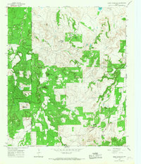
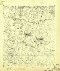 1931 Baird1931 Print · USGSCallahan County ranching and rail life are documented here in the early twentieth century. Genealogists and local historians can trace the foundations of Baird, the Rough Creek P.O., and distinctive landmarks like Caddo Peak and Round Mt.
 - 1932 Map of Baird
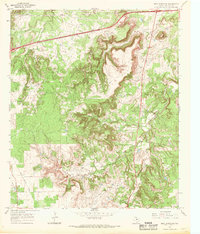
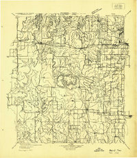 1932 Baird1932 Print · USGSCallahan and Eastland counties appear in the early 1930s, showing the region's transition into the oil and highway era. Genealogists can locate family homes near Belle Plain, Oak Ridge School, and along the Missouri Kansas & Texas railroad.
 - 1954 Map of Abilene, 1966 Print
 1954 Abilene1966 Print · USGSThe Texas Big Country comes into focus in the mid-1950s as petroleum and new water projects reshape the landscape. Local historians can trace the Butterfield Trail, find the Fort Phantom Hill Ruins, and locate numerous small communities along the Texas & Pacific line.2 unique versions available
 - 1958 Map of Abilene
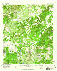
 1958 Abilene1958 Print · USGSMid-century West Texas comes alive in this survey of the Abilene and Stephenville region during a period of steady oil expansion and military growth. Genealogists and local historians can trace the paths of the Texas & Pacific RR through historic towns, locate the Fort Griffin Ruins, and find smaller settlements like Desdemona and Lueders.
 - 1959 Map of Gordon, 1960 Print
 1959 Gordon1960 Print · USGSThe Palo Pinto hills in the late fifties show a landscape defined by the Texas and Pacific railroad and active coal and oil extraction. Local researchers can trace the locations of family burial sites like Thurber Cem and landmarks like Metcalf Gap.2 unique versions available
 - 1965 Map of Huckabay SW, 1967 Print
 1965 Huckabay SW1967 Print · USGSErath County's ranching landscape is captured here in the mid-sixties, showing the rugged drainage basins of the Blue Hills. Genealogists and historians can locate old family burial sites like Old School Hill Cem, School Hill Cem, and Lowell Cem.
 - 1965 Map of Reddy Mountain, 1967 Print
 1965 Reddy Mountain1967 Print · USGSThe Erath and Eastland County line in the mid-1960s shows a landscape balancing cattle country with natural gas extraction. Genealogists and historians can locate rural burial grounds like Tudor Cem or trace the industrial footprint of the X Ray Gas Field and the Old Railroad Grade.
 - 1965 Map of Indian Knoll, 1967 Print
 1965 Indian Knoll1967 Print · USGSThe West Texas rangelands at the crossroads of Stephens and Eastland counties come into focus in the mid-1960s. Genealogists and researchers can trace family-named sites like Graves and explore the industrial footprint of Eureka and the Compressor Sta.
 - 1966 Map of Sipe Springs, 1968 Print
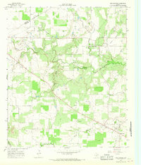 1966 Sipe Springs1968 Print · USGSSipe Springs and the surrounding Comanche County cattle and oil country are captured here in the mid-1960s. Researchers can trace the path of an Old Railroad Grade or locate family sites at Parker Cem and Sipe Springs Cem.2 unique versions available
 - 1966 Map of Rising Star, 1968 Print
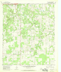
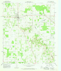 1966 Rising Star1968 Print · USGSCentral Texas during the mid-sixties reveals a landscape of petroleum development and small crossroads settlements. Genealogists and historians can trace the Old Railroad Grade and locate local landmarks like Wolf Valley Ch and Amity.
 - 1966 Map of Cisco North, 1969 Print
 1966 Cisco North1969 Print · USGSCisco and the surrounding Eastland County terrain are shown here in the mid-1960s as oil production and new educational institutions reshaped the local landscape. Researchers can trace family history at Oakwood Cem or explore the mid-century industrial footprint of the Bankline Oil Field and the local Clay Pits.2 unique versions available
 - 1966 Map of Kokomo, 1969 Print
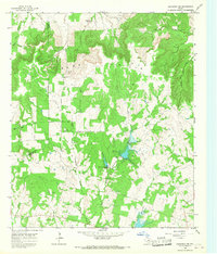
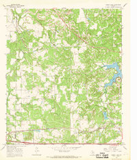
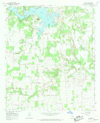 1966 Kokomo1969 Print · USGSEastland County rural life in the mid-sixties is centered on the recently created LAKE LEON and the small settlement of Kokomo. Researchers can trace old family burial sites like Providence Cem and Fredonia Cem or locate early petroleum infrastructure and the M-K-T railroad line.
 - 1966 Map of Desdemona, 1969 Print
 1966 Desdemona1969 Print · USGSDesdemona and the surrounding ranch lands of Eastland and Erath counties appear here in the mid-sixties as the local oil and gas industry matured. Genealogists and historians can trace the Old Railroad Grade, locate the Howard Cem, and find old landmarks like Mockingbird Hill.
 - 1966 Map of Carbon, 1969 Print
 1966 Carbon1969 Print · USGSCarbon and the surrounding Eastland County countryside are captured here in the mid-sixties as the local energy and rail economy shifted. Trace family roots at Murry Memorial Cem or follow the OLD RAILROAD GRADE through Punkin Center and Mangum.
 - 1966 Map of Scranton, 1969 Print
 1966 Scranton1969 Print · USGSAcross the Eastland County ranchlands in the mid-1960s, rural life centered on small communities and family burial grounds. Researchers can trace local lineages at Pisgah Cem and Haskell Cem or explore the early settlements of Scranton and Nimrod.2 unique versions available
 - 1966 Map of Bear Mountain, 1969 Print
 1966 Bear Mountain1969 Print · USGSEastland County during the mid-sixties shows a landscape of deep canyons and growing energy infrastructure. Genealogists and historians can trace the Old Railroad Grade and locate old Oil Wells near Bear Mountain.2 unique versions available
 - 1966 Map of Eastland, 1969 Print
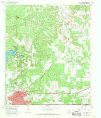
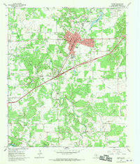
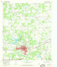 1966 Eastland1969 Print · USGSEastland and the surrounding Texas oil fields are captured here during the mid-sixties at a peak of petroleum and rail activity. Researchers can trace the Old RR Grade and find local landmarks like Pleasant Grove Cem and Lake Brelsford.2 unique versions available
 - 1966 Map of Bernie Lake, 1969 Print
 1966 Bernie Lake1969 Print · USGSThe West Texas borderlands of Callahan and Eastland Counties are shown here during the mid-sixties, dominated by a network of creeks and early industrial infrastructure. Researchers can trace the Texas and Pacific line, locate Dothan Cem, and explore the shoreline of Lake Cisco.
 - 1966 Map of Cisco South, 1969 Print
 1966 Cisco South1969 Print · USGSThe outskirts of Cisco and the settlement of Pleasant Hill appear here in the mid-sixties. Trace family history at Pleasant Hill Cem or locate industrial sites like the Pumping Sta and the Old Railroad Grade.2 unique versions available
 - 1966 Map of Ranger, 1970 Print
 1966 Ranger1970 Print · USGSRanger and Eastland County are shown here in the mid-sixties, capturing a landscape defined by petroleum production and deep-rooted local communities. Researchers can trace rural life through landmarks like Merriman Ch, Evergreen Cem, and the settlement at Olden.2 unique versions available
 - 1967 Map of Wayland, 1970 Print
 1967 Wayland1970 Print · USGSStephens County ranchlands and the small community of Wayland are captured here in the late sixties as the local landscape transitioned. Researchers can trace the Old Railroad Grade and locate family names at Acker Cem or Gunsight Cem.2 unique versions available
 - 1967 Map of Harpersville, 1970 Print
 1967 Harpersville1970 Print · USGSStephens County ranching and oil country are mapped here in the late sixties. Genealogists and historians can trace local family landmarks like Harpersville Cem, the site of Little Flock Ch, and an Old Railroad Grade.2 unique versions available
 - 1967 Map of La Casa, 1971 Print
 1967 La Casa1971 Print · USGSThe borderlands of Stephens and Eastland counties appear here in the late sixties as a busy landscape of oil production and cattle ranching. Researchers can trace the Old Railroad Grade and locate local landmarks like New Hope Ch and Mt Zion Cem.2 unique versions available
Showing maps 1-25 of 37
Top cities of Eastland County
- Eastland historical maps
- Cisco historical maps
- Ranger historical maps
- Gorman historical maps
- Rising Star historical maps
- Olden historical maps
See more
Frequently asked questions
- What are the different types of historical maps available for Eastland County?
- What is the oldest map of Eastland County?
- Where can I purchase historical maps of Eastland County for my home or office?
- Where can I download high-res historical maps of Eastland County?
- Are there historical topographic maps available for Eastland County?
- Is there historical aerial imagery available for Eastland County?
- Where are historical maps of Eastland County sourced from?