1960s Maps of Montgomery County, Texas
Explore 17 historic maps of Montgomery County from the 1960s. These maps offer a rare glimpse into what life looked like during the 1960s — showing old roads, neighborhoods, homes, and landmarks that have changed or disappeared over time.
Whether you're researching your family's past, planning a metal detecting trip, or studying how Montgomery County's landscape evolved across the 1960s, these high-resolution maps are a powerful tool for exploring the history of this region.
- Focus on a specific era: All maps on this page are from the 1960s, giving you a focused view of this time period.
- See what’s changed: Compare century-old streets, trails, and buildings to today's modern landscape using overlays and satellite layers.
- Research with precision: Use these maps for genealogy, historical research, land use analysis, or educational projects.
- View, download, or print: Maps are fully viewable online in high resolution, and can be downloaded or printed for your own records.
Start exploring Montgomery County's history through authentic maps from the 1960s. This is your window into the past.
Montgomery County, TX maps
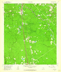
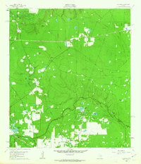
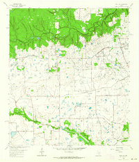
(17)- 1960 Map of Willis, 1961 Print
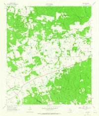
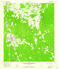 1960 Willis1961 Print · USGSThe town of Willis stands at the edge of the East Texas timberlands in the early sixties, a landscape defined by forest and resource extraction. Researchers can locate family landmarks such as New Hope Ch, the Turner High Sch, and the Missouri Pacific rail line.3 unique versions available
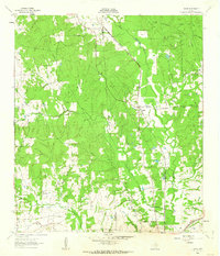
 - 1960 Map of Maynard, 1962 Print
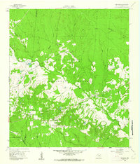 1960 Maynard1962 Print · USGSSan Jacinto County in the early sixties remains a landscape of dense woods and quiet creek bottoms within the Sam Houston National Forest. Genealogists and historians can trace the foundations of Old Waverly and locate local landmarks like the Old Railroad Grade and Hargrove Cem.3 unique versions available
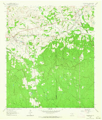
 - 1960 Map of New Waverly, 1962 Print
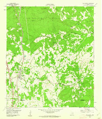 1960 New Waverly1962 Print · USGSThe rural timber and farming lands north of Houston are captured here as they appeared in the early sixties. Genealogists and historians can trace family locations near New Waverly or locate small settlements like Elmina and the secluded Boswell Cem.3 unique versions available
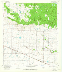
 - 1960 Map of Spring, 1962 Print
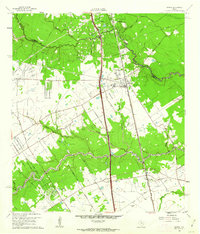 1960 Spring1962 Print · USGSNorthern Harris County is captured here just as the rural oil-and-rail economy began to transition toward modern suburbia. Genealogists can locate family burial sites like Budde Cem and Ehrhardt Cem alongside the old Missouri Pacific line.2 unique versions available
 - 1961 Map of Tamina, 1962 Print
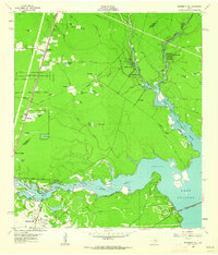
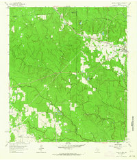
 1961 Tamina1962 Print · USGSSouthern Montgomery County in the early sixties is a landscape of timber and oil, dominated by the West Fork San Jacinto River. Researchers can trace the roots of local communities at Tamina, locate family plots in the Tamina Cem, and explore the rail-side growth near Rayford.4 unique versions available
 - 1961 Map of Moonshine Hill, 1962 Print
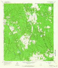
 1961 Moonshine Hill1962 Print · USGSHarris and Montgomery counties appear at a crossroads in the early sixties as oil production and suburban growth meet the San Jacinto riverfront. Researchers can trace family roots at White Oak Cem, locate the wells of Riverside Field, or find early subdivisions like Walden Woods.4 unique versions available
 - 1961 Map of Maedan, 1962 Print
 1961 Maedan1962 Print · USGSThe Montgomery and Harris County borderlands come alive in this early 1960s survey, showing the confluence of river bottomlands and emerging rail-side communities. Trace the roots of Bordersville and Maedan or locate family markers at Enloe Cem and Tetter Cem.2 unique versions available
 - 1962 Map of Keenan, 1963 Print
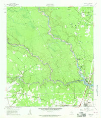
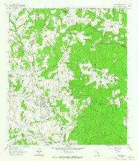
 1962 Keenan1963 Print · USGSMontgomery County was a landscape of timber and rail in the early sixties, defined by the winding course of Lake Creek. Researchers can locate several family burial grounds, including Keenan Cem and Collier Cem, alongside the Spring Tabernacle church.3 unique versions available
 - 1962 Map of Oklahoma, 1963 Print
 1962 Oklahoma1963 Print · USGSSoutheast Texas in the early sixties was a landscape of expanding oil fields and small rural settlements. Genealogists and historians can trace the foundations of Oklahoma and Egypt, locate the Zion Cem, and follow the Missouri Pacific rail line.4 unique versions available
 - 1962 Map of Dacus, 1963 Print
 1962 Dacus1963 Print · USGSSoutheast Texas at the start of the sixties reveals a transition from the Sam Houston National Forest into the rural creek-side communities of Grimes County. Genealogists can locate family sites near Bethel Cem, Mount Mariah Ch, and the settlement of Dacus.2 unique versions available
 - 1962 Map of Plantersville, 1964 Print
 1962 Plantersville1964 Print · USGSPlantersville and its surrounding rail junctions are captured in the early sixties as they served the borderlands of Grimes and Montgomery Counties. Genealogists can trace family names through landmarks like Shannon Cem, Rose Hill Cem, and Center Point Ch.2 unique versions available
 - 1962 Map of Hockley, 1964 Print
 1962 Hockley1964 Print · USGSThis corner of the Texas Gulf Coast in the early sixties centers on Hockley, where the Southern Pacific tracks meet a network of family ranch roads. Genealogists can trace early area residents through the Roberts Cem, Macedonia Cem, and Hegar Cem.3 unique versions available
 - 1962 Map of Rose Hill, 1964 Print
 1962 Rose Hill1964 Print · USGSNorthern Harris County is captured in the early sixties as a ranching and energy-producing landscape. Genealogists can trace family names at Sander Cem and Rose Hill Cem or locate the Letter M Ranch and the local Refinery.3 unique versions available
 - 1962 Map of Magnolia East, 1964 Print
 1962 Magnolia East1964 Print · USGSSoutheast Texas at the start of the sixties reveals a landscape shaped by rail lines and the growing oil industry. Researchers can trace family roots at Decker Prairie Cem or locate rural landmarks like Mt Zion Ch and the Cycling Plant.2 unique versions available
 - 1962 Map of Magnolia West, 1964 Print
 1962 Magnolia West1964 Print · USGSSoutheast Texas in the early sixties remains a landscape of timber and creek bottoms where county lines meet. Genealogists and historians can trace family locations near the Old Sanders Cem, the community of Fetzer, and the Lookout Tower Magnolia.3 unique versions available
 - 1962 Map of Richards, 1964 Print
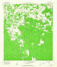
 1962 Richards1964 Print · USGSRichards emerges as a vital railroad junction in the early sixties where two major rail lines met at the edge of the deep pine woods. Researchers can trace family history through sites like Bays Chapel Cem, the local High Sch, and rural landmarks like Robinson Hill.
 - 1963 Map of Loma, 1965 Print
 1963 Loma1965 Print · USGSWalker County rural life in the early sixties is preserved here, centered on the settlement of Loma. Genealogists and historians can locate numerous community landmarks, from Mc Cowan Cem and Mustang Cem to the Hopewell Sch and Pilgrim Rest Ch.
End of results
Showing maps 1-17 of 17
Top cities of Montgomery County
- The Woodlands historical maps
- Conroe historical maps
- Willis historical maps
- Oak Ridge North historical maps
- Roman Forest historical maps
- Panorama Village historical maps
See more
Frequently asked questions
- What are the different types of historical maps available for Montgomery County?
- What is the oldest map of Montgomery County?
- Where can I purchase historical maps of Montgomery County for my home or office?
- Where can I download high-res historical maps of Montgomery County?
- Are there historical topographic maps available for Montgomery County?
- Is there historical aerial imagery available for Montgomery County?
- Where are historical maps of Montgomery County sourced from?