1980s Maps of Montgomery County, Texas
Explore 5 historic maps of Montgomery County from the 1980s. These maps offer a rare glimpse into what life looked like during the 1980s — showing old roads, neighborhoods, homes, and landmarks that have changed or disappeared over time.
Whether you're researching your family's past, planning a metal detecting trip, or studying how Montgomery County's landscape evolved across the 1980s, these high-resolution maps are a powerful tool for exploring the history of this region.
- Focus on a specific era: All maps on this page are from the 1980s, giving you a focused view of this time period.
- See what’s changed: Compare century-old streets, trails, and buildings to today's modern landscape using overlays and satellite layers.
- Research with precision: Use these maps for genealogy, historical research, land use analysis, or educational projects.
- View, download, or print: Maps are fully viewable online in high resolution, and can be downloaded or printed for your own records.
Start exploring Montgomery County's history through authentic maps from the 1980s. This is your window into the past.
Montgomery County, TX maps
(5)- 1982 Map of Maedan
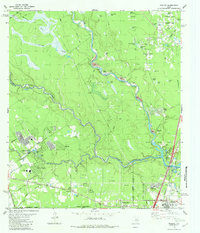 1982 Maedan1982 Print · USGSSoutheast Texas in the early eighties shows a shifting landscape where sprawling river bottomlands meet growing residential communities. Genealogists and local historians can locate several family burial grounds like Enloe Cem, early schools including Teague Sch, and the rail-side community of Bordersville.
 - 1982 Map of Spring
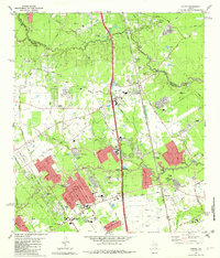 1982 Spring1982 Print · USGSNorth of Houston in the early 1980s, the Spring area was rapidly evolving from a rail-stop settlement into a sprawling suburban hub. Genealogists and historians can trace family-named sites like Ehrhardt Cem and Glameyer Cem alongside newer landmarks like Skyline Airport.
 - 1984 Map of Beaumont
 1984 Beaumont1984 Print · USGSSoutheast Texas in the late seventies and early eighties shows a landscape of expanding reservoirs and deep timber industry. Researchers can trace the development of the Sam Houston National Forest or locate regional landmarks like Grabbs Prairie and the Wynne State Prison Farm.3 unique versions available
 - 1985 Map of Conroe
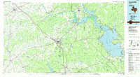
 1985 Conroe1985 Print · USGSSoutheast Texas in the mid-eighties shows a landscape of timberlands and new lakeside developments. Researchers can trace the legacy of rail lines like the Southern Pacific RR or locate rural communities such as Plantersville, Yarboro, and Hufsmith.2 unique versions available
 - 1985 Map of Huntsville
 1985 Huntsville1985 Print · USGSThe East Texas piney woods and the Trinity River basin are captured here in the mid-1980s. Genealogists and historians can trace family locations near Old Waverly, Gospel Hill Ch, and the State Prison Farm during this era of regional growth.2 unique versions available
End of results
Showing maps 1-5 of 5
Top cities of Montgomery County
- The Woodlands historical maps
- Conroe historical maps
- Willis historical maps
- Oak Ridge North historical maps
- Roman Forest historical maps
- Panorama Village historical maps
See more
Frequently asked questions
- What are the different types of historical maps available for Montgomery County?
- What is the oldest map of Montgomery County?
- Where can I purchase historical maps of Montgomery County for my home or office?
- Where can I download high-res historical maps of Montgomery County?
- Are there historical topographic maps available for Montgomery County?
- Is there historical aerial imagery available for Montgomery County?
- Where are historical maps of Montgomery County sourced from?