1920s Maps of Pecos County, Texas
Explore 11 historic maps of Pecos County from the 1920s. These maps offer a rare glimpse into what life looked like during the 1920s — showing old roads, neighborhoods, homes, and landmarks that have changed or disappeared over time.
Whether you're researching your family's past, planning a metal detecting trip, or studying how Pecos County's landscape evolved across the 1920s, these high-resolution maps are a powerful tool for exploring the history of this region.
- Focus on a specific era: All maps on this page are from the 1920s, giving you a focused view of this time period.
- See what’s changed: Compare century-old streets, trails, and buildings to today's modern landscape using overlays and satellite layers.
- Research with precision: Use these maps for genealogy, historical research, land use analysis, or educational projects.
- View, download, or print: Maps are fully viewable online in high resolution, and can be downloaded or printed for your own records.
Start exploring Pecos County's history through authentic maps from the 1920s. This is your window into the past.
Pecos County, TX maps
(11)- 1920 Map of Longfellow
 1920 Longfellow1920 Print · USGSRailroad outposts and high desert terrain define this West Texas survey from the early twentieth century. Genealogists and historians can trace the Southern Pacific line through stops like Purrington, Tesnus, and Rosenfeld, along with landmarks like the Pittsburg Boring.
 - 1921 Map of Fort Stockton, 1965 Print
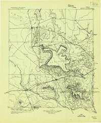
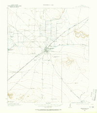 1921 Fort Stockton1965 Print · USGSPecos County ranching and rail life are documented here during the early twenties, centered on the hub of Fort Stockton. Genealogists and historians can locate family landmarks like the Odom Ranch, Old Martin Place, and rural Leon Valley School.
 - 1923 Map of Fort Stockton
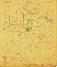 1923 Fort Stockton1923 Print · USGSWest Texas ranching and rail commerce thrive in this early 1920s portrait of Pecos County. Genealogists and historians can locate family-named landmarks like Brannon Ranch and Odom Ranch or trace the early paths of the Kansas City Mexico and Orient railroad.
 - 1923 Map of Hess Canyon
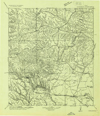
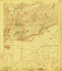 1923 Hess Canyon1923 Print · USGSBrewster and Pecos counties in the early twenties show a landscape defined by the high desert ranching tradition. Genealogists and historians can trace family-named sites across the Glass Mountains, including the Kendrick Ranch, Dessie Ranch, and the Youngblood Place.4 unique versions available
 - 1923 Map of Sierra Madera
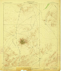 1923 Sierra Madera1923 Print · USGSPecos County was a land of expansive ranching and isolated peaks in the early 1920s. Researchers can trace early West Texas land use and drainage patterns through family-named landmarks like Elsinore Ranch, Tulley Ranch, and the prominent Sierra Madera.2 unique versions available
 - 1928 Map of Crane
 1928 Crane1928 Print · USGSWest Texas ranching and the early oil boom meet at the Pecos River during the late twenties. Trace the growth of new petroleum hubs at Crane and McCamey alongside family-named landmarks like McElroy and Cody Bell.
 - 1928 Map of Sanderson
 1928 Sanderson1928 Print · USGSTerrell County ranching and railroad life come into focus in the late 1920s, showing the area's transition from frontier outposts to a connected rail corridor. Genealogists and historians can locate remote family sites like Big Canyon Headquarters or trace the old Southern Pacific line through Sanderson and Thurston.
 - 1928 Map of Comanche Spring
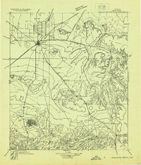 1928 Comanche Spring1928 Print · USGSWest Texas ranching and transportation intersect in the late twenties near the historic waters of Comanche Spring. Researchers can trace early highway routes like the Old Spanish Trail and find remote rail sidings at Elsinore and Scharbaugh.
 - 1929 Map of Sheffield
 1929 Sheffield1929 Print · USGSWest Texas ranching and the early oil boom meet along the Pecos River in the late twenties. Researchers can trace the Old Spanish Trail through Sheffield or locate historical sites like Fort Lancaster and the Yates Oil Field.
 - 1929 Map of Hovey
 1929 Hovey1929 Print · USGSIn the Trans-Pecos during the late twenties, the railroad and early motor trails dictated the rhythm of life across the mesa country. Researchers can trace the path of the Old Spanish Trail, locate rural stops like Chancellor, and identify family landmarks like Hayter and Williams.
 - 1929 Map of Independence Draw Quadrangle
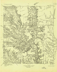
 1929 Independence Draw Quadrangle1929 Print · USGSPecos and Terrell Counties come into focus during the late 1920s as ranching outposts and the Old Spanish Trail defined the West Texas landscape. Genealogists and historians can trace family-named sites like Harral Headquarters, the Salt Works, and the abandoned site at Free (Abd).
End of results
Showing maps 1-11 of 11
Top cities of Pecos County
- Fort Stockton historical maps
- Iraan historical maps
- Imperial historical maps
- Sheffield historical maps
- Coyanosa historical maps
Frequently asked questions
- What are the different types of historical maps available for Pecos County?
- What is the oldest map of Pecos County?
- Where can I purchase historical maps of Pecos County for my home or office?
- Where can I download high-res historical maps of Pecos County?
- Are there historical topographic maps available for Pecos County?
- Is there historical aerial imagery available for Pecos County?
- Where are historical maps of Pecos County sourced from?