Old Maps of Pecos County, Texas for Metal Detecting
Plan your next treasure hunt with 621 historic maps of Pecos County. Find old homesites, ghost towns, trails, and gathering spots that may be lost to time — perfect for identifying promising metal detecting locations.
- Locate forgotten sites: Uncover places like long-lost settlements, abandoned rail lines, or gathering spots.
- Plan better hunts: Use map overlays combined with LiDAR or satellite views to narrow in on historically rich areas.
- Made for detectorists: Thousands of hobbyists use these maps to discover relics, coins, and hidden history.
Use these historic maps to boost your research and find new opportunities beneath the surface of Pecos County.
Pecos County, TX maps
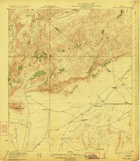
(621)- 1894 Map of Fort Davis, 1961 Print
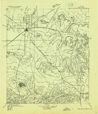
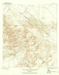 1894 Fort Davis1961 Print · USGSWest Texas in the late nineteenth century was a frontier of family ranching and vital springs. Genealogists and historians can trace the early locations of Fort Davis and numerous homesteads like Wards Ranch, Mahle's Ranch, and Huelster.
 - 1897 Map of Fort Davis
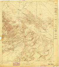 1897 Fort Davis1897 Print · USGSWest Texas ranching life and mountain topography are preserved in this 1890s survey centered on the frontier outpost of Fort Davis. Researchers can trace early family landholdings and essential water sites like Wards Ranch, Toyahvale, and Phantom Lake.3 unique versions available
 - 1920 Map of Longfellow
 1920 Longfellow1920 Print · USGSRailroad outposts and high desert terrain define this West Texas survey from the early twentieth century. Genealogists and historians can trace the Southern Pacific line through stops like Purrington, Tesnus, and Rosenfeld, along with landmarks like the Pittsburg Boring.
 - 1921 Map of Fort Stockton, 1965 Print
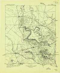
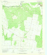
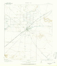 1921 Fort Stockton1965 Print · USGSPecos County ranching and rail life are documented here during the early twenties, centered on the hub of Fort Stockton. Genealogists and historians can locate family landmarks like the Odom Ranch, Old Martin Place, and rural Leon Valley School.
 - 1923 Map of Fort Stockton
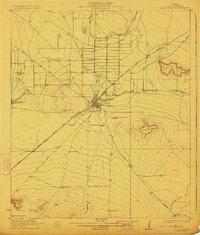 1923 Fort Stockton1923 Print · USGSWest Texas ranching and rail commerce thrive in this early 1920s portrait of Pecos County. Genealogists and historians can locate family-named landmarks like Brannon Ranch and Odom Ranch or trace the early paths of the Kansas City Mexico and Orient railroad.
 - 1923 Map of Hess Canyon
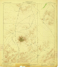
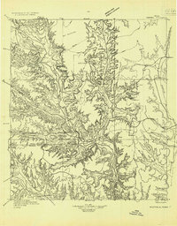
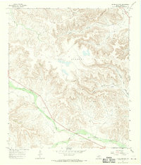
 1923 Hess Canyon1923 Print · USGSBrewster and Pecos counties in the early twenties show a landscape defined by the high desert ranching tradition. Genealogists and historians can trace family-named sites across the Glass Mountains, including the Kendrick Ranch, Dessie Ranch, and the Youngblood Place.4 unique versions available
 - 1923 Map of Sierra Madera
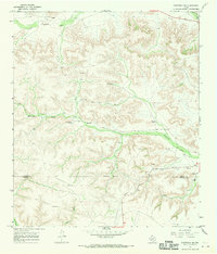
 1923 Sierra Madera1923 Print · USGSPecos County was a land of expansive ranching and isolated peaks in the early 1920s. Researchers can trace early West Texas land use and drainage patterns through family-named landmarks like Elsinore Ranch, Tulley Ranch, and the prominent Sierra Madera.2 unique versions available
 - 1928 Map of Crane
 1928 Crane1928 Print · USGSWest Texas ranching and the early oil boom meet at the Pecos River during the late twenties. Trace the growth of new petroleum hubs at Crane and McCamey alongside family-named landmarks like McElroy and Cody Bell.
 - 1928 Map of Sanderson
 1928 Sanderson1928 Print · USGSTerrell County ranching and railroad life come into focus in the late 1920s, showing the area's transition from frontier outposts to a connected rail corridor. Genealogists and historians can locate remote family sites like Big Canyon Headquarters or trace the old Southern Pacific line through Sanderson and Thurston.
 - 1928 Map of Comanche Spring
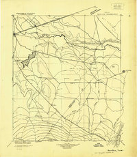
 1928 Comanche Spring1928 Print · USGSWest Texas ranching and transportation intersect in the late twenties near the historic waters of Comanche Spring. Researchers can trace early highway routes like the Old Spanish Trail and find remote rail sidings at Elsinore and Scharbaugh.
 - 1929 Map of Sheffield
 1929 Sheffield1929 Print · USGSWest Texas ranching and the early oil boom meet along the Pecos River in the late twenties. Researchers can trace the Old Spanish Trail through Sheffield or locate historical sites like Fort Lancaster and the Yates Oil Field.
 - 1929 Map of Hovey
 1929 Hovey1929 Print · USGSIn the Trans-Pecos during the late twenties, the railroad and early motor trails dictated the rhythm of life across the mesa country. Researchers can trace the path of the Old Spanish Trail, locate rural stops like Chancellor, and identify family landmarks like Hayter and Williams.
 - 1929 Map of Independence Draw Quadrangle
 1929 Independence Draw Quadrangle1929 Print · USGSPecos and Terrell Counties come into focus during the late 1920s as ranching outposts and the Old Spanish Trail defined the West Texas landscape. Genealogists and historians can trace family-named sites like Harral Headquarters, the Salt Works, and the abandoned site at Free (Abd).
 - 1931 Map of Barstow
 1931 Barstow1931 Print · USGSWest Texas ranching and early oil exploration meet along the Pecos River during the early thirties. Trace family ranch sites like Eclipse Ranch and Courtney Ranch or locate early rural education hubs at Welcome School.
 - 1954 Map of Pecos, 1964 Print
 1954 Pecos1964 Print · USGSMid-century West Texas reveals a landscape of expanding oil fields and cattle ranching along the winding Pecos River. Local historians can trace family ranch lands like Goodrich Ranch, follow the Texas and Pacific rails, or locate the historic Horsehead Crossing.3 unique versions available
 - 1954 Map of Fort Stockton, 1965 Print
 1954 Fort Stockton1965 Print · USGSWest Texas ranching and the early energy industry converge in this mid-century survey of the Trans-Pecos. Genealogists and historians can locate specific family lands like Graef Brothers Ranch and trace the paths of the Old Spanish Trail and the Southern Pacific railroad.3 unique versions available
 - 1954 Map of Sonora, 1965 Print
 1954 Sonora1965 Print · USGSThe Edwards Plateau and West Texas ranching country come alive in this mid-century survey of the canyons and plateaus. Genealogists and historians can trace the remote settlements of Pandale and Loma Alta or follow the path of the Panhandle and Santa Fe RR.2 unique versions available
 - 1957 Map of Pecos
 1957 Pecos1957 Print · USGSWest Texas in the mid-fifties is a landscape of desert oil fields and vital rail corridors. Researchers can trace the sprawling Pyote Air Force Base, the historic Horsehead Crossing, and the rail stops at Mentone and Saragosa.
 - 1958 Map of Sonora
 1958 Sonora1958 Print · USGSThe Edwards Plateau and Trans-Pecos region come alive in the late fifties, showing a landscape of remote ranchlands and historic frontier outposts. Trace the legacy of Fort Lancaster Ruins, the limestone depths of Devils Sinkhole Cavern, and the path of the Pecos River.
 - 1958 Map of Fort Stockton
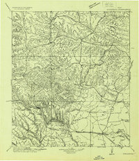
 1958 Fort Stockton1958 Print · USGSThe Trans-Pecos region of West Texas in the late fifties is a landscape of vast mesas and isolated ranching hubs. Genealogists and historians can trace the paths of the Texas and New Orleans RR through Alpine or locate early settlements like Bakersfield and Sanderson.
 - 1963 Map of Ligon Ranch, 1965 Print
 1963 Ligon Ranch1965 Print · USGSThe Pecos River valley and the expanding West Texas oil fields define this mid-century landscape. Researchers can trace the layout of the Automotive Proving Ground and remote outposts like Ligon Ranch and Alberts Well.2 unique versions available
 - 1963 Map of Rio Pecos Ranch, 1965 Print
 1963 Rio Pecos Ranch1965 Print · USGSWest Texas ranching and petroleum production meet along the river in the early sixties. Researchers can trace the layout of the Waha Oil Field, the remote Rio Pecos Ranch, and irrigation works like the Grand Canal.3 unique versions available
 - 1967 Map of Twelvemile Camp, 1970 Print
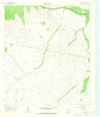
 1967 Twelvemile Camp1970 Print · USGSCrockett and Pecos counties in the late sixties were defined by the expansion of the energy sector into the high-desert canyons. Researchers can trace the mid-century petroleum footprint through numerous Oil Wells and the Pipeline near Twelvemile Camp.
 - 1967 Map of Divide Country, 1970 Print
 1967 Divide Country1970 Print · USGSPecos County was a hub of petroleum exploration in the late sixties, as shown by this survey of the high plateau. Researchers can trace the industrial footprint of numerous Oil Wells and Drill Holes scattered across Upper Fourmile Draw and Riffle Canyon.2 unique versions available
 - 1967 Map of Sheffield NW, 1970 Print
 1967 Sheffield NW1970 Print · USGSThe Pecos and Terrell county border country comes to life in this late 1960s study of the West Texas landscape. Genealogists and historians can trace the established Cannon Ranch, Slaughter Ranch, and the Perkins Windmill across the draws.2 unique versions available
Showing maps 1-25 of 621
Top cities of Pecos County
- Fort Stockton historical maps
- Iraan historical maps
- Imperial historical maps
- Sheffield historical maps
- Coyanosa historical maps
Frequently asked questions
- What are the different types of historical maps available for Pecos County?
- What is the oldest map of Pecos County?
- Where can I purchase historical maps of Pecos County for my home or office?
- Where can I download high-res historical maps of Pecos County?
- Are there historical topographic maps available for Pecos County?
- Is there historical aerial imagery available for Pecos County?
- Where are historical maps of Pecos County sourced from?