Old Maps of Emery County, Utah for Genealogy
Trace your family roots with 328 historic maps of Emery County. These high-res maps reveal old neighborhoods, homesites, landmarks, and streets — helping you uncover where your ancestors lived and how the area evolved over time.
- Explore historic neighborhoods: Identify where your relatives may have lived in the 1800s or 1900s.
- Compare maps over time: Trace the changes in streets, buildings, and landmarks for multi-generational research.
- Perfect for genealogy & ancestry research: Used by family historians and researchers to map out lineage and migration.
These maps are an incredible resource for exploring your personal connection to Emery County's past.
Emery County, UT maps
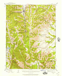
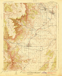
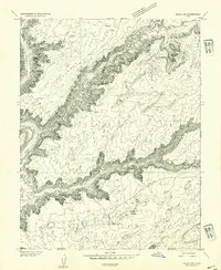
(328)- 1885 Map of San Rafael
 1885 San Rafael1885 Print · USGSCentral Utah at the height of the Powell Survey reveals a land defined by water and stone. Genealogists and historians can locate early settlements like Tidwell and Blake or trace the intricate river systems of Labyrinth Canyon and San Rafael Valley.5 unique versions available
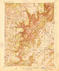
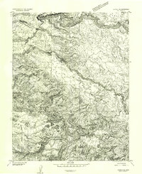
 - 1885 Map of Manti
 1885 Manti1885 Print · USGSCentral Utah during the mid-1880s reveals a growing network of agricultural towns and vital rail lines through the high desert. Researchers can trace early family settlements along the San Pete River and locate historic depots like Pleasant Valley Junction or the early township of Nephi.4 unique versions available
 - 1885 Map of La Sal
 1885 La Sal1885 Print · USGSSoutheast Utah in the mid-1880s remains a frontier of dramatic river canyons and high mountain peaks. Genealogists and historians can trace the early footprints of Moab and Plainfield or locate the high summits of Mt Peale and the path of the Green River.6 unique versions available
 - 1885 Map of Fish Lake
 1885 Fish Lake1885 Print · USGSThe high plateaus and early canyon settlements of central Utah are documented here in the mid-1880s, shortly after the Powell Survey. Genealogists and historians can trace early families in Salina, Antimony, and Cousharem, or locate remote sites like Bean Spring.
 - 1886 Map of Price River
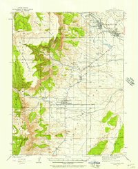
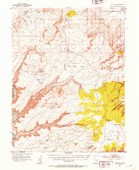
 1886 Price River1886 Print · USGSEmery County and the surrounding canyonlands are documented here just as the railroad arrived in the mid-1880s. Local researchers can trace the early path of the Denver and Rio Grande Western R. R. through Castle Gate, Price, and Sunny Side.4 unique versions available
 - 1895 Map of Manti, 1921 Print
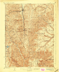
 1895 Manti1921 Print · USGSSanpete County and the high plateaus of central Utah are captured in the late nineteenth century as irrigation and railroads transformed the valley floor. Genealogists and historians can trace the early layout of Manti, Ephraim, and Nephi, alongside smaller outposts like Fountain Green and Mayfield.
 - 1896 Map of Price River
 1896 Price River1896 Print · USGSEmery County was transitioning into a vital rail corridor during the late nineteenth century. Trace the early layout of Price and Castle Dale alongside the winding Denver and Rio Grande Western RR and the depths of Desolation Canyon.
 - 1896 Map of Fish Lake, 1899 Print
 1896 Fish Lake1899 Print · USGSSouthern Utah in the late nineteenth century is a land of high plateaus and isolated river settlements. Trace early pioneer outposts like Thurber, Teardale, and Antimony alongside geological marvels such as Fish Lake and the Water Pocket Flexure.4 unique versions available
 - 1922 Map of Wasatch
 1922 Wasatch1922 Print · USGSThe high-elevation grazing lands of Sanpete and Emery County are captured in the early 1920s as a landscape of isolated ridges and ranch outposts. Genealogists and historians can trace family-named landmarks like Larsen Ranch and Hansen Ranch near Lower Joes Valley.
 - 1923 Map of Scofield, 1957 Print
 1923 Scofield1957 Print · USGSThe high-country coal camps of Carbon and Emery counties are shown in detail during the early twenties as the mining industry boomed. Trace the historic Denver & Rio Grande Western RR line between Scofield and Clear Creek or locate remote sites like the Wattis Mine.2 unique versions available
 - 1923 Map of Castle Dale, 1958 Print
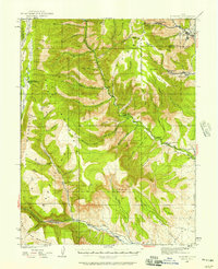
 1923 Castle Dale1958 Print · USGSEmery County was a landscape of high-plateau ranching and early coal mining during the 1920s. Genealogists and researchers can trace family-named sites like the Ferron Mill, the Grillpack Mine, and Blackburns Ranch across the desert benches.3 unique versions available
 - 1923 Map of Hiawatha, 1958 Print
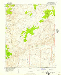
 1923 Hiawatha1958 Print · USGSThe coal mining districts of Emery and Carbon counties are at their industrial peak during the 1920s. Genealogists and historians can trace the rail-linked company towns of Hiawatha and Mohrland and locate remote landmarks like Swaseys Ranch or the Huntington Mine.4 unique versions available
 - 1925 Map of Scofield
 1925 Scofield1925 Print · USGSCoal mining and mountain ranching dominate the Wasatch Plateau in the 1920s as the rail line pushes deep into the canyons. Genealogists and historians can trace the footprint of early industrial camps like Clear Creek and Wattis, or locate family landmarks such as Seeley Ranch and the Gibson Mine.2 unique versions available
 - 1925 Map of Castle Dale
 1925 Castle Dale1925 Print · USGSEmery County during the 1920s shows a landscape defined by pioneer irrigation and early coal exploration. Genealogists and local historians can locate family landmarks such as Blackburns Ranch, the Ferron Mill, and the Axel Anderson Mine.2 unique versions available
 - 1925 Map of Acord Lakes
 1925 Acord Lakes1925 Print · USGSThe high plateau and canyon country of Sevier and Emery Counties are captured here in the mid-1920s as ranching and early mining defined the local economy. Researchers can locate remote family landmarks like Peacocks Place, the Browning Mine, and the historic Quitchupah Ranch.3 unique versions available
 - 1925 Map of Hiawatha
 1925 Hiawatha1925 Print · USGSThe Wasatch Plateau’s coal mining frontier comes to life in this mid-1920s survey of the canyon lands. Researchers can trace early industrial footprints at the Hiawatha Mine and Mohrland, or locate remote family holdings like Swaseys Ranch.
 - 1948 Map of Woodside, 1960 Print
 1948 Woodside1960 Print · USGSEmery County was a landscape of coal mining and rail transport at the end of the 1940s. Genealogists and local historians can trace the foundations of Woodside and the Silvagni Ranch or locate the Geneva Coal Mine at the foot of the Book Cliffs.
 - 1949 Map of Woodside, 1973 Print
 1949 Woodside1973 Print · USGSThe Book Cliffs and Price River valley come into focus during the late 1940s, a period of active rail transport and coal mining. Researchers can locate the Geneva Coal Mine, the small community of Woodside, and the remote Silvagni Ranch along the desert washes.
 - 1950 Map of Woodside
 1950 Woodside1950 Print · USGSEmery County was a landscape of deep canyons and rail-side outposts at the midpoint of the twentieth century. Researchers can trace the industrial footprint of the Geneva Coal Mine or locate early settlements and family landmarks like Woodside, Silvagni Ranch, and the local Cem.2 unique versions available
 - 1951 Map of The Knoll, 1953 Print
 1951 The Knoll1953 Print · USGSThe Grand and San Juan County line at the dawn of the 1950s is a landscape of remote cattle ranges and deep river canyons. Researchers can trace the era's ranching infrastructure through Dubinky Well, Gil Well, and the grazing lands of Arth Pasture.5 unique versions available
 - 1952 Map of Tidwell 4 SE, 1954 Print
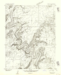
 1952 Tidwell 4 SE1954 Print · USGSThe Green River serpentine loops dominate this mid-century desert landscape at the meeting point of four Utah counties. Trace the river's path through the iconic Bowknot Bend and locate historic access points like Mineral Bottom and Horse Thief Bottom along the canyon floor.
 - 1952 Map of Tidwell 4 NE, 1954 Print
 1952 Tidwell 4 NE1954 Print · USGSThe canyons of the Green River dominate this early 1950s survey of the Utah high desert. Historians and geologists can trace the winding county boundary and locate remote water sources like Keg Spring and Spring Canyon.
 - 1952 Map of Moab 3 SW, 1954 Print
 1952 Moab 3 SW1954 Print · USGSThe Green River backcountry of eastern Utah is captured here in the early fifties, showing a landscape of sheer cliffs and isolated river bottoms. Trace the rugged terrain of Mineral Canyon and find remote water sources like Horsethief Spring and the Green River flats.
 - 1952 Map of Notom 2 NE, 1954 Print
 1952 Notom 2 NE1954 Print · USGSThe high plateau country of Wayne and Emery Counties is captured here in the early 1950s before the development of major modern access. Geologists and local historians can trace the intricate drainages of South Creek and Hartnet Draw through the Middle Desert.
 - 1952 Map of Wild Horse, 1957 Print
 1952 Wild Horse1957 Print · USGSThe high desert of Emery County is captured here in the early 1950s, documenting a period when only jeep trails and remote springs sustained travel through the swell. Researchers can trace the geological barriers of the San Rafael Reef and locate early water sources like Cistern Tanks and Bullberry Spring.2 unique versions available
Showing maps 1-25 of 328
Top cities of Emery County
- Huntington historical maps
- Castle Dale historical maps
- Ferron historical maps
- Orangeville historical maps
- Green River historical maps
- Cleveland historical maps
See more
Frequently asked questions
- What are the different types of historical maps available for Emery County?
- What is the oldest map of Emery County?
- Where can I purchase historical maps of Emery County for my home or office?
- Where can I download high-res historical maps of Emery County?
- Are there historical topographic maps available for Emery County?
- Is there historical aerial imagery available for Emery County?
- Where are historical maps of Emery County sourced from?