1960s Maps of Emery County, Utah
Explore 41 historic maps of Emery County from the 1960s. These maps offer a rare glimpse into what life looked like during the 1960s — showing old roads, neighborhoods, homes, and landmarks that have changed or disappeared over time.
Whether you're researching your family's past, planning a metal detecting trip, or studying how Emery County's landscape evolved across the 1960s, these high-resolution maps are a powerful tool for exploring the history of this region.
- Focus on a specific era: All maps on this page are from the 1960s, giving you a focused view of this time period.
- See what’s changed: Compare century-old streets, trails, and buildings to today's modern landscape using overlays and satellite layers.
- Research with precision: Use these maps for genealogy, historical research, land use analysis, or educational projects.
- View, download, or print: Maps are fully viewable online in high resolution, and can be downloaded or printed for your own records.
Start exploring Emery County's history through authentic maps from the 1960s. This is your window into the past.
Emery County, UT maps
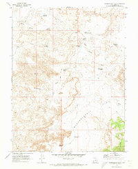
(41)- 1960 Map of Price
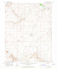
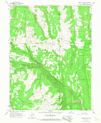
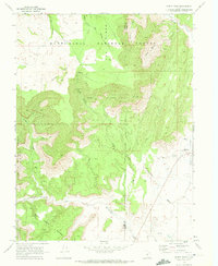
 1960 Price1960 Print · USGSCentral Utah in the late fifties was a landscape of coal-hauling railroads and high plateau settlements. Genealogists and local historians can trace the rail-to-river economy from Price to the mountain mining camps of Hiawatha, Dragerton, and Sunnyside.2 unique versions available
 - 1960 Map of Salina
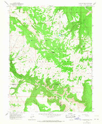
 1960 Salina1960 Print · USGSThe high plateaus and canyonlands of south-central Utah appear in the early sixties as a region of remote ranching towns and developing parklands. Researchers can trace historic settlements like Fruita and Loa or locate the uranium mines and the tracks of the Denver and Rio Grande Western RR.2 unique versions available
 - 1960 Map of Moab
 1960 Moab1960 Print · USGSThe canyonlands and high plateaus of the Utah-Colorado border are shown here during the mid-century uranium boom. Researchers can trace the river-and-rail corridors of the Colorado River and the Denver and Rio Grande Western near Moab and Uravan.3 unique versions available
 - 1962 Map of Moab
 1962 Moab1962 Print · USGSThe canyon country of southeastern Utah and western Colorado is captured here in the early sixties, showing the reach of the Denver and Rio Grande Western through the desert. Researchers can trace the layout of mining settlements like Uravan and old railroad stops at Cisco and Sagers Station.
 - 1962 Map of Salina
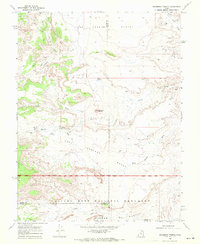
 1962 Salina1962 Print · USGSSevier County and the surrounding desert wilderness appear here in the early sixties as a network of isolated river valley towns and high-altitude forests. Researchers can locate remote landmarks like Fruita, trace the Denver & Rio Grande Western RR, and find backcountry sites like the Aquarius Ranger Station.
 - 1962 Map of Price
 1962 Price1962 Print · USGSCentral Utah during the early sixties shows a landscape balancing high-mountain forestry with valley agriculture and coal mining. Genealogists and historians can trace the Denver and Rio Grande Western rail lines through industrial hubs like Price or locate formerly active sites like Coal City (abandoned).
 - 1963 Map of Robbers Roost Canyon, 1964 Print
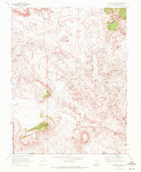
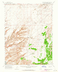 1963 Robbers Roost Canyon1964 Print · USGSIn the early 1960s, this Wayne County desert remained a vast expanse of ranching outposts and canyon hideouts. Researchers can trace remote routes like Angels Trail or locate isolated landmarks like Biddlecome Ranch and the eponymous Robbers Roost Spring.3 unique versions available
 - 1963 Map of Hanksville, 1965 Print
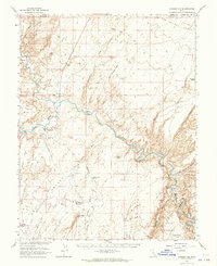 1963 Hanksville1965 Print · USGSHanksville and the surrounding high desert are documented here during the early 1960s as aviation and energy interests moved into the region. Local historians can trace the town's footprint near the Hanksville Cem and the confluence of the Fremont River and Muddy Creek.3 unique versions available
 - 1963 Map of Gunnison Butte, 1965 Print
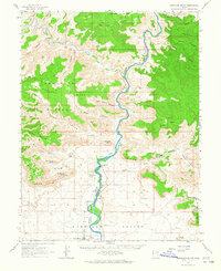 1963 Gunnison Butte1965 Print · USGSThe Green River Valley and the iconic Book Cliffs are documented here in the early sixties as the regional landscape supported ranching and transit. Researchers can trace the river's path past Gunnison Butte to find the Elgin Cem and the Diversion Dam Spillway.2 unique versions available
 - 1963 Map of Bowknot Bend, 1965 Print
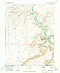 1963 Bowknot Bend1965 Print · USGSThe Green River serpentine loops dominate this 1960s desert landscape during a period of active uranium prospecting. Trace the remote river economy at Hey Joe Mine and follow the isolated routes leading to Spring Canyon Ford and Bowknot Bend.2 unique versions available
 - 1963 Map of The Flat Tops, 1965 Print
 1963 The Flat Tops1965 Print · USGSEmery and Wayne counties appear here during a period of mid-century geological exploration across the San Rafael Desert. Researchers can locate remote resource infrastructure including prospects, a Landing Field, and landmarks like The Flat Tops.2 unique versions available
 - 1964 Map of Moab
 1964 Moab1964 Print · USGSThe canyonlands of eastern Utah and western Colorado are captured here in the mid-1960s, a time when uranium mining shaped the local economy. Researchers can trace the river-and-rail network through Sinbad Valley and locate mining outposts like Uravan and Vancorum.
 - 1965 Map of Moab
 1965 Moab1965 Print · USGSSoutheast Utah and Western Colorado are mapped here in the mid-sixties, showcasing a landscape of high plateaus and deep river canyons. Genealogists and historians can trace the mining-era towns of Uravan and Paradox or locate remote landmarks like Castleton and Dead Horse Point.
 - 1966 Map of Flagstaff Peak, 1968 Print
 1966 Flagstaff Peak1968 Print · USGSThe high country of the Manti-La Sal National Forest in the mid-1960s reveals a landscape of remote mountain cabins and high-altitude mining infrastructure. Researchers can trace the path of the Mine Tramway and locate early landmarks like Jason Cabin and Wrigley Springs Reservoir.2 unique versions available
 - 1966 Map of Joes Valley Reservoir, 1968 Print
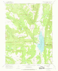 1966 Joes Valley Reservoir1968 Print · USGSThe high country of the Manti-La Sal National Forest is shown here during the mid-1960s, as the newly established reservoir reshaped the drainage basins. Genealogists and historians can trace the foundations of the area at Olsen Ranch, the Orange Olsen Administrative Site, and the paths of the Wagon Road Ridge.2 unique versions available
 - 1966 Map of South Tent Mtn, 1968 Print
 1966 South Tent Mtn1968 Print · USGSThe high ridges of the Manti-La Sal National Forest are captured here in the mid-sixties as a landscape of remote cabins and mountain tunnels. Researchers can trace the routes of Skyline Drive and several pack trails to find Soren Peterson Meadow, Becks Cabin, and the waters of Potters Ponds.3 unique versions available
 - 1966 Map of Ferron Canyon, 1968 Print
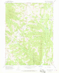
 1966 Ferron Canyon1968 Print · USGSThe Wasatch Plateau in the mid-sixties reveals a working landscape of high-country cattle camps and rugged pack trails. Genealogists and researchers can trace local movement along the Singleton Trail and locate family landmarks like Wrigley Hill and the Horn Mtn Cow Camp.
 - 1968 Map of Solomons Temple, 1972 Print
 1968 Solomons Temple1972 Print · USGSThe high desert of south-central Utah is captured here in the late sixties at the junction of three counties. Geologists and local historians can trace isolated water sources like Birch Spring and Jeffery Reservoir alongside landmarks like Solomons Temple.2 unique versions available
 - 1968 Map of Walker Flat, 1972 Print
 1968 Walker Flat1972 Print · USGSThe high plateaus on the Sevier and Emery county line appear here in the late sixties as a landscape of mining and desert transit. Trace the routes of jeep trails leading to the Dog Valley Mine, Browning Mine, and the overlooks at Windy Peak.3 unique versions available
 - 1968 Map of Mesa Butte, 1972 Print
 1968 Mesa Butte1972 Print · USGSEmery County was undergoing a major transformation in the late sixties as new highway infrastructure pushed through the high desert. Researchers can trace the legacy of mining and rural travel through the Cowboy Mine, the old Lone Tree Crossing, and the prominent Mesa Butte.3 unique versions available
 - 1968 Map of Emery West, 1972 Print
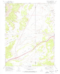
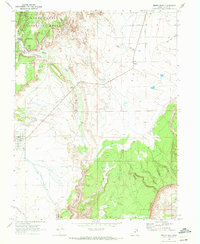
 1968 Emery West1972 Print · USGSThe high desert and forest boundaries of central Utah come into focus in the late sixties, capturing the settlement of Emery and its surrounding watershed. Genealogists and researchers can locate the Emery Cem, trace the Link Canyon Mine, and follow the path of Quitchupah Creek.
 - 1968 Map of Salvation Creek, 1972 Print
 1968 Salvation Creek1972 Print · USGSEmery and Wayne Counties were centers of geological exploration and remote ranching in the late sixties. Researchers can trace early petroleum surveys and desert navigation via Oil Well Bench, Rock Springs, and the border of Capitol Reef National Monument.
 - 1968 Map of Emery East, 1972 Print
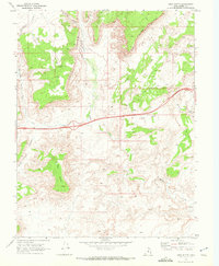
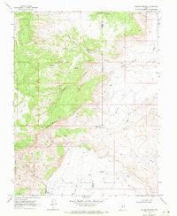
 1968 Emery East1972 Print · USGSEmery and Moore are captured during the late sixties as agricultural hubs between the national forest and the desert reefs. Genealogists and historians can trace local landmarks like the Cem cemetery, the winding Muddy Creek, and industrial markers like the Gravel Pit.2 unique versions available
 - 1968 Map of Willow Springs, 1972 Print
 1968 Willow Springs1972 Print · USGSThe high deserts of Sevier and Emery Counties come into focus during the late sixties, showing a landscape defined by livestock ranching and resource exploration. Researchers can find isolated landmarks like Last Chance Ranch, Jims Farm, and several deep-country Test Holes scattered across the Last Chance Desert.
 - 1968 Map of Mussentuchit Flat, 1973 Print
 1968 Mussentuchit Flat1973 Print · USGSEmery County's high-desert landscape is captured here in the late sixties, showcasing the remote water systems and trails of the Utah interior. Researchers can trace historic stock routes and water sources like Mussentuchit Reservoir, Deadman Peak, and Sand Cove Spring.3 unique versions available
Showing maps 1-25 of 41
Top cities of Emery County
- Huntington historical maps
- Castle Dale historical maps
- Ferron historical maps
- Orangeville historical maps
- Green River historical maps
- Cleveland historical maps
See more
Frequently asked questions
- What are the different types of historical maps available for Emery County?
- What is the oldest map of Emery County?
- Where can I purchase historical maps of Emery County for my home or office?
- Where can I download high-res historical maps of Emery County?
- Are there historical topographic maps available for Emery County?
- Is there historical aerial imagery available for Emery County?
- Where are historical maps of Emery County sourced from?