1990s Maps of Emery County, Utah
Explore 9 historic maps of Emery County from the 1990s. These maps offer a rare glimpse into what life looked like during the 1990s — showing old roads, neighborhoods, homes, and landmarks that have changed or disappeared over time.
Whether you're researching your family's past, planning a metal detecting trip, or studying how Emery County's landscape evolved across the 1990s, these high-resolution maps are a powerful tool for exploring the history of this region.
- Focus on a specific era: All maps on this page are from the 1990s, giving you a focused view of this time period.
- See what’s changed: Compare century-old streets, trails, and buildings to today's modern landscape using overlays and satellite layers.
- Research with precision: Use these maps for genealogy, historical research, land use analysis, or educational projects.
- View, download, or print: Maps are fully viewable online in high resolution, and can be downloaded or printed for your own records.
Start exploring Emery County's history through authentic maps from the 1990s. This is your window into the past.
Emery County, UT maps
(9)- 1991 Map of Butler Canyon
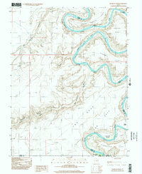
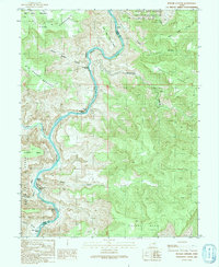 1991 Butler Canyon1991 Print · USGSThe Green River canyons in Grand and Emery counties are shown here as they appeared in the early 1990s. Boaters and historians can trace the sequence of white water and landmarks, from Nefertiti Rapids and Nefertiti Rock to Butler Rapids.
 - 1991 Map of Blue Castle Butte
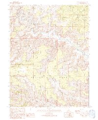
 1991 Blue Castle Butte1991 Print · USGSThe Green River corridor at the turn of the 1990s reveals the intersection of irrigation infrastructure and desert geography. Local researchers can trace the historic Elgin Cemetery or examine water systems at Tusher Dam and the headgate.
 - 1991 Map of Tusher Canyon
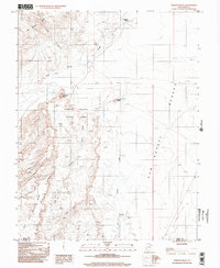
 1991 Tusher Canyon1991 Print · USGSThe high desert canyons and the Green River corridor are mapped here as they appeared in the early 1990s. Local researchers can trace old ranching infrastructure like Water Tanks or locate landmarks such as Gunnison Butte and Swaseys Rapids.
 - 1991 Map of Jenny Canyon
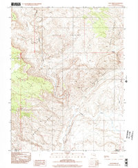
 1991 Jenny Canyon1991 Print · USGSEmery County's high desert plateaus and river canyons are captured in detail during the early nineties. Researchers can trace the winding course of the Price River and map the rugged boundaries of the Beckwith Plateau and Elliott Mesa.
 - 1996 Map of Bowknot Bend, 2002 Print
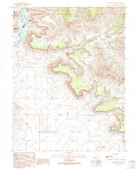
 1996 Bowknot Bend2002 Print · USGSThe Green River loops through Emery County during the mid-nineties, revealing the serpentine path of Bowknot Bend. Researchers can trace old 4WD routes to riverside flats like Woodruff Bottom, or locate high-desert landmarks such as Keg Spring and Horsethief Point.
 - 1996 Map of Goblin Valley, 2002 Print
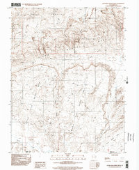
 1996 Goblin Valley2002 Print · USGSEmery County was undergoing significant geological documentation in the mid-nineties as its distinctive landscapes were mapped in detail. Researchers can locate remote water sources like Buckskin Spring and landmarks such as Mollys Castle and Wild Horse Butte.
 - 1996 Map of Mineral Canyon, 2002 Print
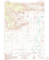
 1996 Mineral Canyon2002 Print · USGSThe Green River serpentine through Emery and Grand counties in the late twentieth century, creating the dramatic Bowknot Bend. Geologists and backcountry travelers can trace remote 4WD routes to Mineral Bottom and scout early mining Prospects near the river.
 - 1996 Map of Little Wild Horse Mesa, 2002 Print
 1996 Little Wild Horse Mesa2002 Print · USGSThe San Rafael Swell in the late twentieth century is shown here through its intricate canyon systems and high mesas. Trace the remote network of 4WD tracks and geographic landmarks like San Rafael Reef, Chute Canyon, and Bell Canyon.
 - 1996 Map of Hunt Draw, 2002 Print
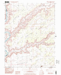
 1996 Hunt Draw2002 Print · USGSThe high desert along the Emery and Wayne county border was captured in the mid-nineties as a landscape of dramatic reefs and deep canyons. Geologists and researchers can trace the winding Muddy Creek and locate historic mining sites like the Adits near the San Rafael Reef.
End of results
Showing maps 1-9 of 9
Top cities of Emery County
- Huntington historical maps
- Castle Dale historical maps
- Ferron historical maps
- Orangeville historical maps
- Green River historical maps
- Cleveland historical maps
See more
Frequently asked questions
- What are the different types of historical maps available for Emery County?
- What is the oldest map of Emery County?
- Where can I purchase historical maps of Emery County for my home or office?
- Where can I download high-res historical maps of Emery County?
- Are there historical topographic maps available for Emery County?
- Is there historical aerial imagery available for Emery County?
- Where are historical maps of Emery County sourced from?