1970s Maps of Emery County, Utah
Explore 8 historic maps of Emery County from the 1970s. These maps offer a rare glimpse into what life looked like during the 1970s — showing old roads, neighborhoods, homes, and landmarks that have changed or disappeared over time.
Whether you're researching your family's past, planning a metal detecting trip, or studying how Emery County's landscape evolved across the 1970s, these high-resolution maps are a powerful tool for exploring the history of this region.
- Focus on a specific era: All maps on this page are from the 1970s, giving you a focused view of this time period.
- See what’s changed: Compare century-old streets, trails, and buildings to today's modern landscape using overlays and satellite layers.
- Research with precision: Use these maps for genealogy, historical research, land use analysis, or educational projects.
- View, download, or print: Maps are fully viewable online in high resolution, and can be downloaded or printed for your own records.
Start exploring Emery County's history through authentic maps from the 1970s. This is your window into the past.
Emery County, UT maps
(8)- 1978 Map of Hiawatha, 1979 Print
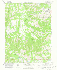 1978 Hiawatha1979 Print · USGSThe coal country of Carbon and Emery Counties comes to life in this late-seventies survey of the Wasatch Plateau. Researchers can trace the rail-and-mine network connecting the Hiawatha and Mohrland settlements to the Hiawatha Mine and the Utah Railway.
 - 1979 Map of Rilda Canyon
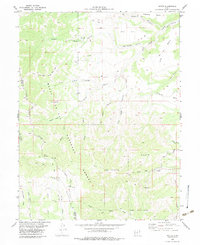
 1979 Rilda Canyon1979 Print · USGSEmery and Sanpete counties meet along these high forest ridges in the late 1970s, an area defined by deep drainages and remote pack trails. Researchers can locate historic resource sites like Mines and Drill Holes or trace routes through Rilda Canyon and Biddlecome Hollow.2 unique versions available
 - 1979 Map of Ferron
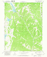
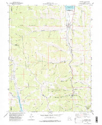
 1979 Ferron1979 Print · USGSEmery County agriculture is centered on the town of Ferron in the late 1970s, where complex irrigation systems meet the forest edge. Genealogists and local historians can locate the County Home, San Rafael Sch, and early hydraulic works like the King Aqueduct.
 - 1979 Map of Candland Mountain
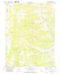
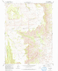
 1979 Candland Mountain1979 Print · USGSThe high ridges of the Manti-La Sal National Forest are captured here in the late seventies during a period of active water storage and resource use. Researchers can trace historic access routes via the Pack Trail to landmarks like the Stuart Guard Station and the Old Fireside Mine.
 - 1979 Map of Wattis, 1983 Print
 1979 Wattis1983 Print · USGSThe coal country of Carbon and Emery Counties is captured here in the late seventies, showing the industrial pulse of the Wasatch Plateau. Researchers can trace the rail-to-mine network at Wattis and the Plateau Mine, or explore remote landmarks like Star Point and The Steeps.
 - 1979 Map of Scofield, 1983 Print
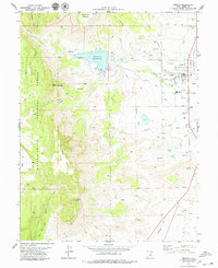
 1979 Scofield1983 Print · USGSThe coal mining corridor of Carbon County is captured here in the late seventies, showing the industrial pulse of Scofield and Clear Creek. Genealogists and historians can trace the Denver and Rio Grande Western rail line, old workings like the Old Black Diamond Mine, and the local Cem.
 - 1979 Map of Mahogany Point, 1984 Print
 1979 Mahogany Point1984 Print · USGSEmery County, Utah, is shown in the late 1970s as a hub for mountain mining operations and forest management. Researchers can locate active resource extraction at the Trail Mountain Mine and Oliphant Mine, or trace historic routes like the Roans Pack Trail.
 - 1979 Map of The Cap, 1991 Print
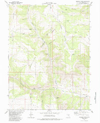
 1979 The Cap1991 Print · USGSEmery County was a landscape of high plateaus and active mining during the late seventies. Researchers can trace resource history and old routes through the Killpack Mine, the Pack Trail, and family-named landmarks like Biddiecome Hollow.
End of results
Showing maps 1-8 of 8
Top cities of Emery County
- Huntington historical maps
- Castle Dale historical maps
- Ferron historical maps
- Orangeville historical maps
- Green River historical maps
- Cleveland historical maps
See more
Frequently asked questions
- What are the different types of historical maps available for Emery County?
- What is the oldest map of Emery County?
- Where can I purchase historical maps of Emery County for my home or office?
- Where can I download high-res historical maps of Emery County?
- Are there historical topographic maps available for Emery County?
- Is there historical aerial imagery available for Emery County?
- Where are historical maps of Emery County sourced from?