2000-2009 Maps of Emery County, Utah
Explore 17 historic maps of Emery County from 2000-2009. These maps offer a rare glimpse into what life looked like during the 2000s — showing old roads, neighborhoods, homes, and landmarks that have changed or disappeared over time.
Whether you're researching your family's past, planning a metal detecting trip, or studying how Emery County's landscape evolved across the 2000s, these high-resolution maps are a powerful tool for exploring the history of this region.
- Focus on a specific era: All maps on this page are from the 2000s, giving you a focused view of this time period.
- See what’s changed: Compare century-old streets, trails, and buildings to today's modern landscape using overlays and satellite layers.
- Research with precision: Use these maps for genealogy, historical research, land use analysis, or educational projects.
- View, download, or print: Maps are fully viewable online in high resolution, and can be downloaded or printed for your own records.
Start exploring Emery County's history through authentic maps from the 2000s. This is your window into the past.
Emery County, UT maps
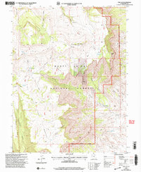
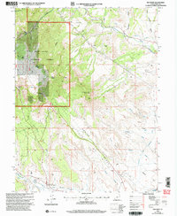
(17)- 2001 Map of Walker Flat, 2003 Print
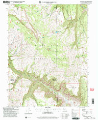
 2001 Walker Flat2003 Print · USGSThe high plateau of Sevier and Emery counties is captured here at the turn of the millennium. Researchers can trace the region's mining legacy through the Dog Valley Mine, Browning Mine, and various unnamed prospects along Ivie Creek.
 - 2001 Map of Cathedral Mountain, 2003 Print
 2001 Cathedral Mountain2003 Print · USGSCapitol Reef National Park and the surrounding high desert are documented here during the early 2000s, showing the intersection of federal lands and geologic wonders. Researchers can trace the remote tracks of The Hartnet and locate vital water sources like South Desert Spring and Ring Water Spring.
 - 2001 Map of Wattis, 2004 Print
 2001 Wattis2004 Print · USGSCarbon County's high-elevation coal country is captured here during a period of active mining and forest management at the turn of the millennium. Researchers can trace the industrial infrastructure of the Star Point Mine and the remote settlement of Wattis along the slopes of Gentry Mountain.
 - 2001 Map of Scofield, 2004 Print
 2001 Scofield2004 Print · USGSScofield and the surrounding high-mountain mining districts are captured here at the dawn of the new millennium. Historians and genealogists can trace the footprint of the energy industry and local infrastructure through the Skyline Mine, the Scofield Cemetery, and Clear Creek.
 - 2001 Map of Flagstaff Peak, 2004 Print
 2001 Flagstaff Peak2004 Print · USGSHigh in the Wasatch Plateau during the early 2000s, this area shows the intersection of three Utah counties within the Manti-La Sal National Forest. Researchers can trace the water network from Wrigley Springs Reservoir to Blue Lake and locate the summit of Flagstaff Peak.
 - 2001 Map of Emery East, 2004 Print
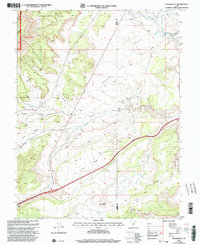
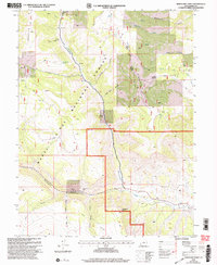
 2001 Emery East2004 Print · USGSThe arid landscape and agricultural outskirts of Emery County are documented in the early 2000s. Genealogists and local historians can trace the irrigation network of Emery Canal and locate the Cem and Gravel Pit near Emery.
 - 2001 Map of Ferron, 2004 Print
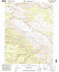
 2001 Ferron2004 Print · USGSFerron and the surrounding Emery County plateau are shown here at the turn of the millennium, as the community expanded alongside its vital water systems. Researchers can trace the extensive irrigation networks of the Molen Ditch or locate the historic Hole In The Rock Trail.
 - 2001 Map of Ferron Canyon, 2004 Print
 2001 Ferron Canyon2004 Print · USGSSanpete County high country is shown here in the years following the turn of the millennium, documenting the working landscape of the Wasatch Plateau. Researchers can locate remote camps and early trails like Horn Mtn Cow Camp, the Dairy Trail, and Dairy Point.
 - 2001 Map of The Cap, 2004 Print
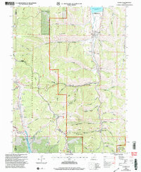
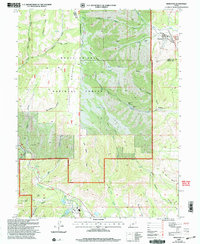
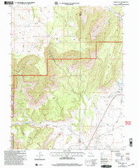
 2001 The Cap2004 Print · USGSEmery County was undergoing a period of resource management and exploration within the Manti-La Sal National Forest during the early 2000s. Genealogists and researchers can trace family-named features like Biddlecome Ridge and Nielson Swale or locate sites of industrial interest such as the Anderson Mine.
 - 2001 Map of Hiawatha, 2004 Print
 2001 Hiawatha2004 Print · USGSThe coal-mining landscapes of the Wasatch Plateau are captured here at the turn of the twenty-first century. Genealogists and industrial historians can trace the operations of the Hiawatha Mine, locate the local Cemetery, and study the rail-and-road layout of Mohrland.
 - 2001 Map of Candland Mountain, 2004 Print
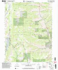
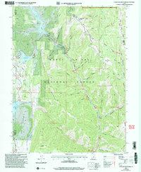 2001 Candland Mountain2004 Print · USGSThe high-elevation plateaus and canyons of the Manti-La Sal National Forest are shown here just after the turn of the millennium. Trace industrial and water history through features like Electric Lake, Monument Peak, and the small settlement at Stuart.
 - 2001 Map of Joes Valley Reservoir, 2004 Print
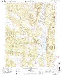 2001 Joes Valley Reservoir2004 Print · USGSSanpete and Emery counties show a landscape of high-country water management and national forest life at the turn of the millennium. Researchers can trace land use through the Olsen Ranch, old grazing Corrals, and the extensive Reeder Trail network.
 - 2001 Map of Red Point, 2004 Print
 2001 Red Point2004 Print · USGSEmery County was a hub of coal production and irrigation engineering at the turn of the century. You can trace the footprint of the Des-Bee-Dove Mines, explore the infrastructure of the Cleveland Canal, and find the Wilberg Mine Historical Monument.
 - 2001 Map of Emery West, 2004 Print
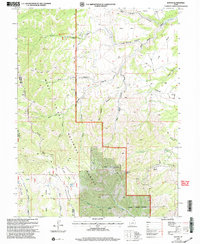
 2001 Emery West2004 Print · USGSThe high plateau country of central Utah meets the desert at the turn of the millennium. Genealogists and local historians can trace the outskirts of Emery, locating the Emery Cem, the Link Canyon Mine, and the local Rodeo Grounds.
 - 2001 Map of Rilda Canyon, 2004 Print
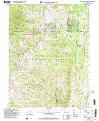
 2001 Rilda Canyon2004 Print · USGSThe Wasatch Plateau of the early 2000s reveals a complex landscape of coal mining and mountain terrain at the Sanpete and Emery county line. Local historians and researchers can trace the industrial footprint of the Genwal Mine, the Huntington #4 Mine, and the Indian Creek (Site).
 - 2001 Map of South Tent Mountain, 2004 Print
 2001 South Tent Mountain2004 Print · USGSThe high Wasatch Plateau of central Utah is captured here at the start of the millennium, following the winding path of Skyline Drive. Researchers can find evidence of early water management and high-country grazing at Soren Peterson Meadow, the Mountain Tunnel, and Potters Ponds.
 - 2001 Map of Mahogany Point, 2004 Print
 2001 Mahogany Point2004 Print · USGSHigh-altitude coal mining and rugged forest management define this Emery County landscape at the turn of the twenty-first century. Researchers can trace industrial footprints at the Trail Mountain Mine and Oliphant Mine or locate family-named landmarks like Nielson Swale.
End of results
Showing maps 1-17 of 17
Top cities of Emery County
- Huntington historical maps
- Castle Dale historical maps
- Ferron historical maps
- Orangeville historical maps
- Green River historical maps
- Cleveland historical maps
See more
Frequently asked questions
- What are the different types of historical maps available for Emery County?
- What is the oldest map of Emery County?
- Where can I purchase historical maps of Emery County for my home or office?
- Where can I download high-res historical maps of Emery County?
- Are there historical topographic maps available for Emery County?
- Is there historical aerial imagery available for Emery County?
- Where are historical maps of Emery County sourced from?