1900s (20th Century) Maps of Emery County, Utah
Explore 200 historic maps of Emery County from the 1900s (20th Century). These maps offer a rare glimpse into what life looked like during the 1900s — showing old roads, neighborhoods, homes, and landmarks that have changed or disappeared over time.
Whether you're researching your family's past, planning a metal detecting trip, or studying how Emery County's landscape evolved across the 1900s, these high-resolution maps are a powerful tool for exploring the history of this region.
- Focus on a specific era: All maps on this page are from the 1900s, giving you a focused view of this time period.
- See what’s changed: Compare century-old streets, trails, and buildings to today's modern landscape using overlays and satellite layers.
- Research with precision: Use these maps for genealogy, historical research, land use analysis, or educational projects.
- View, download, or print: Maps are fully viewable online in high resolution, and can be downloaded or printed for your own records.
Start exploring Emery County's history through authentic maps from the 1900s. This is your window into the past.
Emery County, UT maps
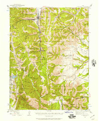
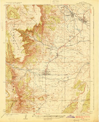
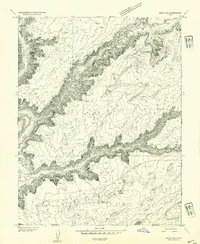
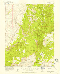
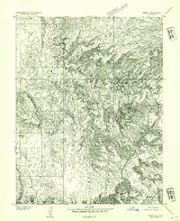
(200)- 1922 Map of Wasatch
 1922 Wasatch1922 Print · USGSThe high-elevation grazing lands of Sanpete and Emery County are captured in the early 1920s as a landscape of isolated ridges and ranch outposts. Genealogists and historians can trace family-named landmarks like Larsen Ranch and Hansen Ranch near Lower Joes Valley.
 - 1923 Map of Scofield, 1957 Print
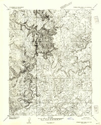
 1923 Scofield1957 Print · USGSThe high-country coal camps of Carbon and Emery counties are shown in detail during the early twenties as the mining industry boomed. Trace the historic Denver & Rio Grande Western RR line between Scofield and Clear Creek or locate remote sites like the Wattis Mine.2 unique versions available
 - 1923 Map of Castle Dale, 1958 Print
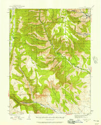
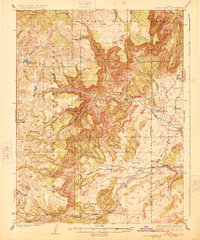
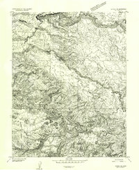
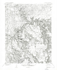
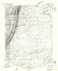
 1923 Castle Dale1958 Print · USGSEmery County was a landscape of high-plateau ranching and early coal mining during the 1920s. Genealogists and researchers can trace family-named sites like the Ferron Mill, the Grillpack Mine, and Blackburns Ranch across the desert benches.3 unique versions available
 - 1923 Map of Hiawatha, 1958 Print
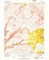
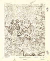
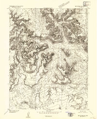
 1923 Hiawatha1958 Print · USGSThe coal mining districts of Emery and Carbon counties are at their industrial peak during the 1920s. Genealogists and historians can trace the rail-linked company towns of Hiawatha and Mohrland and locate remote landmarks like Swaseys Ranch or the Huntington Mine.4 unique versions available
 - 1925 Map of Scofield
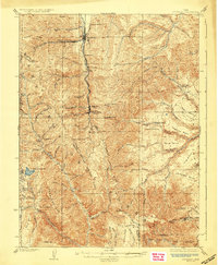 1925 Scofield1925 Print · USGSCoal mining and mountain ranching dominate the Wasatch Plateau in the 1920s as the rail line pushes deep into the canyons. Genealogists and historians can trace the footprint of early industrial camps like Clear Creek and Wattis, or locate family landmarks such as Seeley Ranch and the Gibson Mine.2 unique versions available
 - 1925 Map of Castle Dale
 1925 Castle Dale1925 Print · USGSEmery County during the 1920s shows a landscape defined by pioneer irrigation and early coal exploration. Genealogists and local historians can locate family landmarks such as Blackburns Ranch, the Ferron Mill, and the Axel Anderson Mine.2 unique versions available
 - 1925 Map of Acord Lakes
 1925 Acord Lakes1925 Print · USGSThe high plateau and canyon country of Sevier and Emery Counties are captured here in the mid-1920s as ranching and early mining defined the local economy. Researchers can locate remote family landmarks like Peacocks Place, the Browning Mine, and the historic Quitchupah Ranch.3 unique versions available
 - 1925 Map of Hiawatha
 1925 Hiawatha1925 Print · USGSThe Wasatch Plateau’s coal mining frontier comes to life in this mid-1920s survey of the canyon lands. Researchers can trace early industrial footprints at the Hiawatha Mine and Mohrland, or locate remote family holdings like Swaseys Ranch.
 - 1948 Map of Woodside, 1960 Print
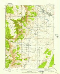
 1948 Woodside1960 Print · USGSEmery County was a landscape of coal mining and rail transport at the end of the 1940s. Genealogists and local historians can trace the foundations of Woodside and the Silvagni Ranch or locate the Geneva Coal Mine at the foot of the Book Cliffs.
 - 1949 Map of Woodside, 1973 Print
 1949 Woodside1973 Print · USGSThe Book Cliffs and Price River valley come into focus during the late 1940s, a period of active rail transport and coal mining. Researchers can locate the Geneva Coal Mine, the small community of Woodside, and the remote Silvagni Ranch along the desert washes.
 - 1950 Map of Woodside
 1950 Woodside1950 Print · USGSEmery County was a landscape of deep canyons and rail-side outposts at the midpoint of the twentieth century. Researchers can trace the industrial footprint of the Geneva Coal Mine or locate early settlements and family landmarks like Woodside, Silvagni Ranch, and the local Cem.2 unique versions available
 - 1951 Map of The Knoll, 1953 Print
 1951 The Knoll1953 Print · USGSThe Grand and San Juan County line at the dawn of the 1950s is a landscape of remote cattle ranges and deep river canyons. Researchers can trace the era's ranching infrastructure through Dubinky Well, Gil Well, and the grazing lands of Arth Pasture.5 unique versions available
 - 1952 Map of Tidwell 4 SE, 1954 Print
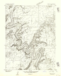
 1952 Tidwell 4 SE1954 Print · USGSThe Green River serpentine loops dominate this mid-century desert landscape at the meeting point of four Utah counties. Trace the river's path through the iconic Bowknot Bend and locate historic access points like Mineral Bottom and Horse Thief Bottom along the canyon floor.
 - 1952 Map of Tidwell 4 NE, 1954 Print
 1952 Tidwell 4 NE1954 Print · USGSThe canyons of the Green River dominate this early 1950s survey of the Utah high desert. Historians and geologists can trace the winding county boundary and locate remote water sources like Keg Spring and Spring Canyon.
 - 1952 Map of Moab 3 SW, 1954 Print
 1952 Moab 3 SW1954 Print · USGSThe Green River backcountry of eastern Utah is captured here in the early fifties, showing a landscape of sheer cliffs and isolated river bottoms. Trace the rugged terrain of Mineral Canyon and find remote water sources like Horsethief Spring and the Green River flats.
 - 1952 Map of Notom 2 NE, 1954 Print
 1952 Notom 2 NE1954 Print · USGSThe high plateau country of Wayne and Emery Counties is captured here in the early 1950s before the development of major modern access. Geologists and local historians can trace the intricate drainages of South Creek and Hartnet Draw through the Middle Desert.
 - 1952 Map of Wild Horse, 1957 Print
 1952 Wild Horse1957 Print · USGSThe high desert of Emery County is captured here in the early 1950s, documenting a period when only jeep trails and remote springs sustained travel through the swell. Researchers can trace the geological barriers of the San Rafael Reef and locate early water sources like Cistern Tanks and Bullberry Spring.2 unique versions available
 - 1952 Map of Torrey, 1958 Print
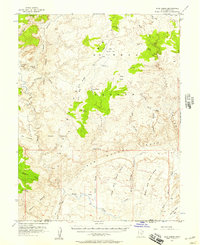
 1952 Torrey1958 Print · USGSTorrey and Teasdale sit at the edge of the desert during the early 1950s, a time when the high plateaus and sandstone reefs were still navigated by jeep trails. Researchers can locate the local Cem, the Elkhorn Ranger Sta, and early infrastructure like the Power Plant along the Fremont River.3 unique versions available
 - 1952 Map of San Rafael Knob, 1958 Print
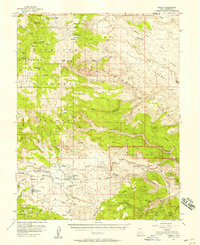
 1952 San Rafael Knob1958 Print · USGSEmery County's high desert is captured in the early 1950s, showing a landscape defined by deep canyons and isolated outposts. Researchers can trace the region's prospecting and ranching roots through the Lucky Strike Mine, Swazy Cabin, and the remote Landing Strip.2 unique versions available
 - 1953 Map of Stinking Spring Creek 2 SE
 1953 Stinking Spring Creek 2 SE1953 Print · USGSEmery County during the early fifties remains a primitive landscape of deep washes and towering buttes. Researchers can locate the isolated Swazy Cabin and trace the paths of Georges Draw and Red Wash through the San Rafael Swell.
 - 1953 Map of Wilsonville SE
 1953 Wilsonville SE1953 Print · USGSThe San Rafael desert in the early fifties is captured here through detailed topography and river courses. Genealogists and desert explorers can trace the winding San Rafael River and the high plateaus of Sids Mountain and The Wedge.
 - 1953 Map of Red Plateau SE, 1954 Print
 1953 Red Plateau SE1954 Print · USGSThe San Rafael Swell in the early fifties was a landscape of remote plateaus and deep desert canyons. Researchers can trace the winding San Rafael River and locate vital water sources like Moonshine Water Hole and the Reservoir.
 - 1953 Map of Emery 4 NE, 1954 Print
 1953 Emery 4 NE1954 Print · USGSCentral Utah’s desert landscape is documented in the early fifties, focusing on the geological complexity of the San Rafael Swell. Researchers can trace the path of the Muddy River and identify localized landmarks like Mussentuchit Knoll and Johns Hole.
 - 1953 Map of Tidwell 2 SW, 1954 Print
 1953 Tidwell 2 SW1954 Print · USGSThe San Rafael Desert in the early fifties is captured here as a landscape of stark contrasts between high ridgelines and arid basins. Geologists and desert historians can trace seasonal drainages like Iron Wash or locate the solitary Water Well (Aband'd).
 - 1953 Map of Red Plateau SW, 1954 Print
 1953 Red Plateau SW1954 Print · USGSThe San Rafael Swell in the early fifties remains a landscape of deep canyons and isolated summits. Researchers can trace early petroleum exploration through Oil Well Test Holes and locate major landmarks like The Wedge and Bottleneck Peak.2 unique versions available
Showing maps 1-25 of 200
Top cities of Emery County
- Huntington historical maps
- Castle Dale historical maps
- Ferron historical maps
- Orangeville historical maps
- Green River historical maps
- Cleveland historical maps
See more
Frequently asked questions
- What are the different types of historical maps available for Emery County?
- What is the oldest map of Emery County?
- Where can I purchase historical maps of Emery County for my home or office?
- Where can I download high-res historical maps of Emery County?
- Are there historical topographic maps available for Emery County?
- Is there historical aerial imagery available for Emery County?
- Where are historical maps of Emery County sourced from?