1980s Maps of Uintah County, Utah
Explore 17 historic maps of Uintah County from the 1980s. These maps offer a rare glimpse into what life looked like during the 1980s — showing old roads, neighborhoods, homes, and landmarks that have changed or disappeared over time.
Whether you're researching your family's past, planning a metal detecting trip, or studying how Uintah County's landscape evolved across the 1980s, these high-resolution maps are a powerful tool for exploring the history of this region.
- Focus on a specific era: All maps on this page are from the 1980s, giving you a focused view of this time period.
- See what’s changed: Compare century-old streets, trails, and buildings to today's modern landscape using overlays and satellite layers.
- Research with precision: Use these maps for genealogy, historical research, land use analysis, or educational projects.
- View, download, or print: Maps are fully viewable online in high resolution, and can be downloaded or printed for your own records.
Start exploring Uintah County's history through authentic maps from the 1980s. This is your window into the past.
Uintah County, UT maps
(17)- 1980 Map of Huntington, 1981 Print
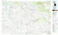
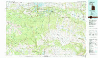
 1980 Huntington1981 Print · USGSEmery and Carbon County landscapes are captured here during the early eighties, showcasing a region defined by high plateaus and mining towns. Researchers can trace the Denver and Rio Grande Western Railroad corridor and locate landmarks like the Cleveland-Lloyd Dinosaur Quarry and Hiawatha.
 - 1980 Map of Vernal, 1982 Print
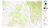
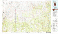
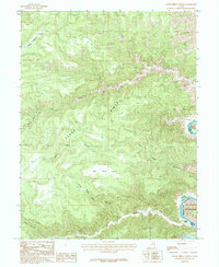
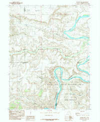
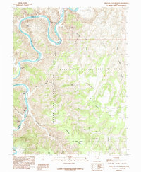
 1980 Vernal1982 Print · USGSThe Uintah Basin in the early 1980s reveals a unique landscape of deep-rooted settlements and emerging energy fields. Genealogists and historians can trace the foundations of Fort Duchesne and the Ouray National Wildlife Refuge alongside active sites like the Red Wash Oil and Gas Field.2 unique versions available
 - 1980 Map of Westwater, 1987 Print
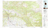
 1980 Westwater1987 Print · USGSGrand County, Utah, and western Colorado are captured here in the early 1980s as a landscape of deep canyons and energy extraction. Trace the path of the Denver and Rio Grande Western Railroad or locate landmarks like Westwater Creek and the Cisco Dome Oil Field.2 unique versions available
 - 1980 Map of Price, 1987 Print
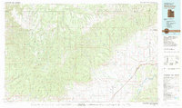
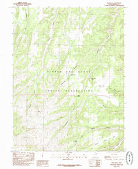
 1980 Price1987 Print · USGSCarbon County in the early 1980s is defined by its deep canyons and intensive coal operations. Researchers can trace the rail spurs and mining works of the Denver and Rio Grande Western Railroad that connect Price, Helper, and the Sunnyside Mine.3 unique versions available
 - 1981 Map of Dutch John, 1982 Print
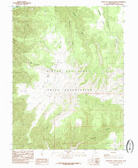
 1981 Dutch John1982 Print · USGSThe high Uinta plateau and the massive reservoir system appear here as they were in the early eighties. Local researchers can trace the roads connecting Manila and Greendale, or locate remote landmarks like the Dyer Mine and Spirit Lake.2 unique versions available
 - 1981 Map of Seep Ridge, 1982 Print
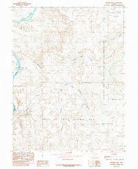
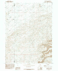
 1981 Seep Ridge1982 Print · USGSEastern Utah at the start of the 1980s reveals a high-desert landscape of energy reserves and tribal lands. Researchers can trace the remnants of Watson (Site), the settlement at Rainbow, and the federal footprint of Naval Oil Shale Reserve No 2.2 unique versions available
 - 1985 Map of Wolf Flat
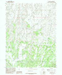
 1985 Wolf Flat1985 Print · USGSThe Uintah and Ouray Indian Reservation in the mid-1980s reveals a high-desert landscape of deeply carved drainages and isolated springs. Researchers can trace the network of named canyons like Mexican Canyon and locate remote water sources such as Charlie Brown Spring and Clear Spring.
 - 1985 Map of Nutters Hole
 1985 Nutters Hole1985 Print · USGSEastern Utah's canyonlands were captured in the mid-1980s, showing a remote landscape of tribal lands and federal oil reserves. Trace the winding Green River and identify the sprawling boundaries of the Naval Oil Shale Reserve No 2 and The Wrinkles.
 - 1985 Map of Cedar Ridge Canyon
 1985 Cedar Ridge Canyon1985 Print · USGSCarbon County, Utah, in the mid-1980s reveals a high-plateau landscape where the Green River meets the Uintah and Ouray Indian Reservation. Trace remote landmarks like the Landing Strip and the turbulent Flat Canyon Rapids.
 - 1985 Map of Chandler Falls
 1985 Chandler Falls1985 Print · USGSDesolation Canyon comes alive in the mid-1980s as the Green River cuts through the Utah wilderness. Researchers can trace the river's dangerous passage through Chandler Falls and Moonwater Rapids or locate remote landmarks like Natural Arch.
 - 1985 Map of Firewater Canyon South
 1985 Firewater Canyon South1985 Print · USGSThe high plateau of eastern Utah is captured here in the mid-1980s, primarily within the Uintah and Ouray Indian Reservation. Topographic enthusiasts and researchers can trace the rugged drainage patterns of Cottonwood Canyon, find the secluded Judith Spring, and locate Chandler Falls.
 - 1985 Map of Crow Knoll
 1985 Crow Knoll1985 Print · USGSThe Duchesne and Uintah county line in the 1980s reveals a desert landscape adapted for ranching and resource extraction. Researchers can trace infrastructure like the Pipeline and find vital water sources including Kilroy Reservoir and Desert Spring.
 - 1985 Map of Moon Bottom
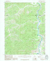
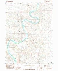 1985 Moon Bottom1985 Print · USGSUintah County in the mid-1980s is defined by the winding course of the Green River as it creates the fertile floodplains of the Uinta Basin. Researchers can trace the river's path through Moon Bottom and Hydes Bottom, or locate early resource infrastructure like the oil well.
 - 1985 Map of Dog Knoll
 1985 Dog Knoll1985 Print · USGSUintah County is mapped here during the mid-eighties, showing the intersection of tribal lands and federal oil shale reserves. Researchers can trace the complex drainage of Tabyago Canyon and Big Canyon across the high Benion Bench.
 - 1985 Map of Steer Ridge Canyon
 1985 Steer Ridge Canyon1985 Print · USGSThe Green River corridor in eastern Utah was still a remote wilderness in the mid-1980s, defined by its powerful rapids and high desert ridges. Modern explorers and researchers can trace the river's path through Log Cabin Rapids and Rock Creek Rapids or locate landmarks like Johnson Spring.
 - 1985 Map of Duches Hole
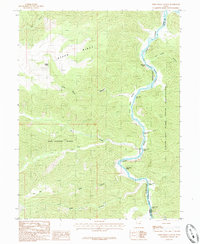
 1985 Duches Hole1985 Print · USGSThe Green River serpentine loops through Uintah County in the 1980s, marking the transition from high plateaus to deep canyon country. Researchers can trace the intersection of the Naval Oil Shale Reserve No 2 and river landmarks like Duches Hole and Slough Grass Bottom.
 - 1985 Map of Firewater Canyon North
 1985 Firewater Canyon North1985 Print · USGSThe Green River serpentine through Desolation Canyon defines this 1980s Uintah County landscape. Boaters and historians can trace navigational hazards like Rock House Rapids and Firewater Rapids alongside the Naval Oil Shale Reserve No 2.
End of results
Showing maps 1-17 of 17
Top cities of Uintah County
Frequently asked questions
- What are the different types of historical maps available for Uintah County?
- What is the oldest map of Uintah County?
- Where can I purchase historical maps of Uintah County for my home or office?
- Where can I download high-res historical maps of Uintah County?
- Are there historical topographic maps available for Uintah County?
- Is there historical aerial imagery available for Uintah County?
- Where are historical maps of Uintah County sourced from?