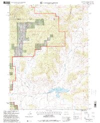
1990s Maps of Uintah County, Utah
Explore 21 historic maps of Uintah County from the 1990s. These maps offer a rare glimpse into what life looked like during the 1990s — showing old roads, neighborhoods, homes, and landmarks that have changed or disappeared over time.
Whether you're researching your family's past, planning a metal detecting trip, or studying how Uintah County's landscape evolved across the 1990s, these high-resolution maps are a powerful tool for exploring the history of this region.
- Focus on a specific era: All maps on this page are from the 1990s, giving you a focused view of this time period.
- See what’s changed: Compare century-old streets, trails, and buildings to today's modern landscape using overlays and satellite layers.
- Research with precision: Use these maps for genealogy, historical research, land use analysis, or educational projects.
- View, download, or print: Maps are fully viewable online in high resolution, and can be downloaded or printed for your own records.
Start exploring Uintah County's history through authentic maps from the 1990s. This is your window into the past.
Uintah County, UT maps
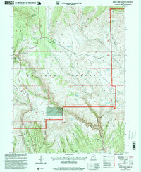
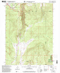
(21)- 1990 Map of Whiterocks Lake, 1995 Print
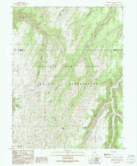
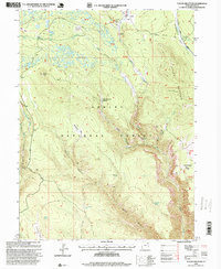
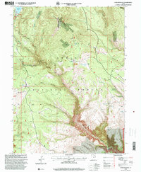
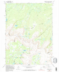 1990 Whiterocks Lake1995 Print · USGSThe high Uinta Mountains are captured here in the late twentieth century, showing a landscape defined by the Old Indian Treaty Boundary and the Ashley National Forest. Researchers can trace old survey lines like the Uintah Special Meridian and find remote landmarks such as Whiterocks Lake and Mount Untermann.
 - 1991 Map of Tenmile Canyon North
 1991 Tenmile Canyon North1991 Print · USGSThe high plateau of eastern Utah in the early nineties reveals a complex network of canyons and ridges along the Uintah and Grand county line. Researchers can trace land use through features like an Oil well and follow the rugged path of Tenmile Canyon or Kelly Meadow Creek.
 - 1991 Map of Black Knolls
 1991 Black Knolls1991 Print · USGSThe eastern Uinta Basin in the early 1990s is captured here, showing the intersection of the Uintah and Ouray Indian Reservation and the Grand County line. Researchers can map the intricate canyon networks of Upper Wagon Canyon and remote landmarks like Picket Corral Ridge.
 - 1991 Map of Moonwater Point
 1991 Moonwater Point1991 Print · USGSThe Tavaputs Plateau and tribal lands come into focus during the early nineties in this detailed topographical study. Researchers can trace remote trails and essential water sources like Anna Laura Spring, Pinto Springs, and the deep reaches of Moonwater Canyon.
 - 1991 Map of Checken Fork
 1991 Checken Fork1991 Print · USGSThe high plateau of the Book Cliffs comes into focus in the early nineties, straddling the Uintah and Grand County line. Genealogists and researchers can locate isolated landmarks like Stevens Cabin and essential water sources such as Moonwater Springs.
 - 1996 Map of Lake Mountain, 1999 Print
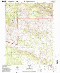 1996 Lake Mountain1999 Print · USGSUintah County's high-elevation borderlands are captured in the late nineties, showing where tribal lands meet national forest peaks. Researchers can locate remote mineral sites like Little Water Mines or trace routes near Gull Lake and the Chalk Cliffs.
 - 1996 Map of Dry Fork, 1999 Print
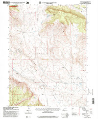
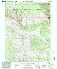 1996 Dry Fork1999 Print · USGSUintah County in the mid-1990s shows a landscape of mountain ridges and managed forest lands just before the turn of the millennium. Researchers can trace historic water sources like Beck Spring and explore local landmarks including the Cemetery and Coal Mine Basin.
 - 1996 Map of Marsh Peak, 1999 Print
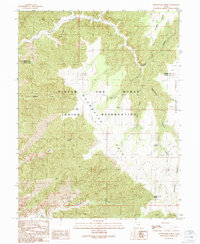
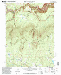
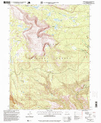 1996 Marsh Peak1999 Print · USGSThe high Uinta wilderness comes into focus in the late nineties, centered on the formidable Marsh Peak. You can trace the remote alpine waters of Lakeshore Basin, follow the Red Cloud Loop, and locate landmarks like the Gaging Station.
 - 1996 Map of Taylor Mountain, 1999 Print
 1996 Taylor Mountain1999 Print · USGSThe high Uinta backcountry is captured here in the late twentieth century, showing a landscape shaped by early military roads and ranching. Trace historical family sites like Galloway Corral, the Carter Military Trail, and the curiously named Death of James Meadow.
 - 1996 Map of Whiterocks Lake, 1999 Print
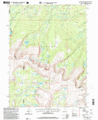 1996 Whiterocks Lake1999 Print · USGSThe High Uintas wilderness appears in detail during the late nineties, showcasing the complex glacial hydrology at the junction of three Utah counties. Trace remote alpine landmarks like Chepeta, the Sheep Creek Canal, and the high waters of Whiterocks Lake.
 - 1996 Map of Steinaker Reservoir, 1999 Print
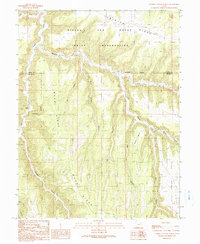
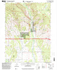
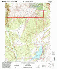 1996 Steinaker Reservoir1999 Print · USGSUintah County in the late nineties is captured here as a landscape of irrigation and historical transit. Genealogists and historians can trace the Carter Military Trail or locate family-named sites like Hall and Markley Park.
 - 1996 Map of East Park Reservoir, 1999 Print
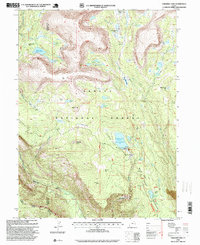
 1996 East Park Reservoir1999 Print · USGSThe high Uinta Mountains of northeastern Utah are captured in the late nineties, showing a landscape defined by water storage and forest trails. Researchers can trace the path of the Uinta Highline Trail or locate remote landmarks like the Spring House and Eagle Creek Bridge.
 - 1996 Map of Burnt Cabin Gorge, 1999 Print
 1996 Burnt Cabin Gorge1999 Print · USGSThe Uinta Mountains high country comes to life in the late twentieth century, showing the rugged transition from the plateau to the gorge. Researchers can trace historic water rights and landmarks like Hole-in-The-Wall, Barker Spring, and Burnt Cabin Gorge.
 - 1996 Map of Blair Basin, 1999 Print
 1996 Blair Basin1999 Print · USGSUintah County's high ranching country is captured here in the late nineties, showing the isolated homesteads and plateau terrain before modern shifts. Researchers can trace historic family-named sites like the Goodrich Ranch, McKeachnie Ranch, and the Searle Ranch.
 - 1996 Map of Paradise Park, 1999 Print
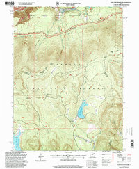
 1996 Paradise Park1999 Print · USGSThe Uinta Mountains wilderness is captured here in the mid-1990s, highlighting alpine water systems and forest management. Researchers can trace the layout of the Paradise Guard Station and mountain landmarks like Paradise Peak and Cliff Lake.
 - 1996 Map of Leidy Peak, 2000 Print
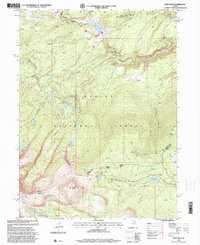 1996 Leidy Peak2000 Print · USGSThe high Uinta Mountains and the historic Carter Military Trail are captured here in the mid-1990s. Researchers can trace high-altitude water systems like the Beaver Canal and historic landmarks including the Fire Lookout Tower.
 - 1996 Map of Dyer Mountain, 2000 Print
 1996 Dyer Mountain2000 Print · USGSDyer Mountain and the high plateaus of Uintah County are captured here in the mid-1990s as a landscape of timber and mountain mining. Trace the historical Military Trail and locate remote mining operations at Dyer Mines and the overlooks of Big Brush Gorge.
 - 1996 Map of Ice Cave Peak, 2000 Print
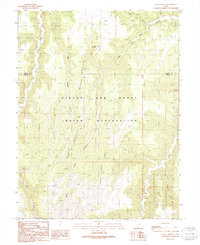
 1996 Ice Cave Peak2000 Print · USGSHigh desert irrigation and mountain ridges define this Uintah County landscape in the mid-nineties. Researchers can locate Reeds Cemetery, the settlement of Elkhorn, and water systems like the Uintah Canal and Duncan Ditch.
 - 1996 Map of Jackson Draw, 2000 Print
 1996 Jackson Draw2000 Print · USGSThe high country of the Uinta Basin in the mid-1990s is captured here, detailing a landscape defined by forest management and water resources. Researchers can trace the drainage of Jackson Draw or locate remote landmarks like the Landing Strip and Matt Warner Reservoir.
 - 1996 Map of Elk Park, 2000 Print
 1996 Elk Park2000 Print · USGSHigh Uinta meadows and deep canyons define this Daggett County landscape in the mid-1990s. Trace old routes across Carter Creek Bridge or explore family-named landmarks like Pat Carroll Park and the high ridges of Trout Creek Peak.
 - 1996 Map of Mount Lena, 2000 Print
 1996 Mount Lena2000 Print · USGSThe high Uinta backcountry on the Daggett and Uintah county line is captured here in the mid-nineties as a hub for wilderness recreation. Local historians can trace seasonal dwellings and remote landmarks like the Deer Lodge Summer Home Area, Stringham Cabin, and the Uinta Highline Trail.
End of results
Showing maps 1-21 of 21
Top cities of Uintah County
Frequently asked questions
- What are the different types of historical maps available for Uintah County?
- What is the oldest map of Uintah County?
- Where can I purchase historical maps of Uintah County for my home or office?
- Where can I download high-res historical maps of Uintah County?
- Are there historical topographic maps available for Uintah County?
- Is there historical aerial imagery available for Uintah County?
- Where are historical maps of Uintah County sourced from?