1970s Maps of Fauquier County, Virginia
Explore 13 historic maps of Fauquier County from the 1970s. These maps offer a rare glimpse into what life looked like during the 1970s — showing old roads, neighborhoods, homes, and landmarks that have changed or disappeared over time.
Whether you're researching your family's past, planning a metal detecting trip, or studying how Fauquier County's landscape evolved across the 1970s, these high-resolution maps are a powerful tool for exploring the history of this region.
- Focus on a specific era: All maps on this page are from the 1970s, giving you a focused view of this time period.
- See what’s changed: Compare century-old streets, trails, and buildings to today's modern landscape using overlays and satellite layers.
- Research with precision: Use these maps for genealogy, historical research, land use analysis, or educational projects.
- View, download, or print: Maps are fully viewable online in high resolution, and can be downloaded or printed for your own records.
Start exploring Fauquier County's history through authentic maps from the 1970s. This is your window into the past.
Fauquier County, VA maps
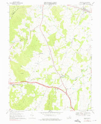
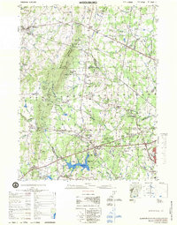
(13)- 1970 Map of Ashby Gap, 1971 Print
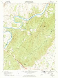 1970 Ashby Gap1971 Print · USGSThe Blue Ridge high country and the winding Shenandoah River dominate the landscape in the early seventies. Genealogists and historians can locate remote mountain landmarks like Ashby Gap, Mt Weather, and the Providence Chapel cemetery.4 unique versions available
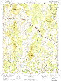
 - 1970 Map of Orlean, 1971 Print
 1970 Orlean1971 Print · USGSFauquier County's rural landscape is captured here in the early seventies, showing a network of historic crossroads and mountain ridges. You can trace family homesteads near Orlean, identify local landmarks like Big Cobbler Mtn, and locate old meeting houses such as Thumb Run Ch.4 unique versions available
 - 1970 Map of Rectortown, 1972 Print
 1970 Rectortown1972 Print · USGSFauquier and Loudoun counties appear in the early 1970s as a landscape of established horse farms and historic hamlets. Researchers can trace the Southern rail line through Rectortown, find local landmarks like Ivy Hill Cem, and locate the Middleburg Training Track.3 unique versions available
 - 1970 Map of Marshall, 1972 Print
 1970 Marshall1972 Print · USGSFauquier County’s horse country and Piedmont ridges are captured here in the early seventies as new infrastructure began to reshape the landscape. Local historians can trace family-named peaks like England Mtn and rural crossroads such as Brookes Corner and Meadowville.2 unique versions available
 - 1970 Map of Upperville, 1976 Print
 1970 Upperville1976 Print · USGSNorthern Fauquier County and the Blue Ridge foothills are captured in the early seventies as the region maintained its rural character. Genealogists and historians can trace the locations of old country churches like Pleasant Vale Ch and rail stops at Markham or Delaplane.3 unique versions available
 - 1971 Map of Massies Corner, 1972 Print
 1971 Massies Corner1972 Print · USGSThe rural Virginia Piedmont comes to life in the early seventies, centered on the historic crossroads of Massies Corner and Amissville. Genealogists and historians can locate family cemeteries, country churches like Mt Moriah Ch, and the mills along the Thornton River.3 unique versions available
 - 1972 Map of Chester Gap, 1977 Print
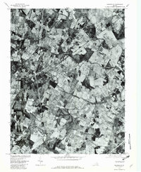
 1972 Chester Gap1977 Print · USGSThe Blue Ridge foothills of northern Virginia are captured in this early 1970s aerial survey just as the landscape was beginning a new chapter of growth. Researchers can trace rural property lines and historic road patterns around Browntown and Chester Gap.
 - 1972 Map of Linden, 1977 Print
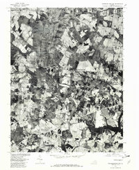
 1972 Linden1977 Print · USGSThe Blue Ridge foothills and Shenandoah Valley are revealed in this 1970s orthophotograph, capturing the area's rural character during a period of transition. Genealogists and local researchers can trace property lines and roads around Linden, Markham, and the Shenandoah River.
 - 1972 Map of Flint Hill, 1977 Print
 1972 Flint Hill1977 Print · USGSRappahannock and Fauquier counties are captured in the early seventies during a period of steady agricultural tradition. Researchers can trace the layout of historic crossroads settlements like Flint Hill and Hume through detailed aerial orthophotography.
 - 1977 Map of Middleburg, 1979 Print
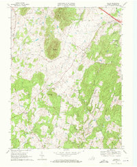
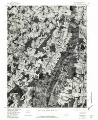
 1977 Middleburg1979 Print · USGSNorthern Virginia in the late seventies reveals a landscape transitioning from rural estate country to a growing suburban corridor. Researchers can locate significant Civil War sites at Manassas National Battlefield Park and trace family names through Buchannon Gap Cem or the Linton Hall Military Sch.
 - 1977 Map of Nokesville, 1982 Print
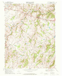
 1977 Nokesville1982 Print · USGSNorthern Virginia was a landscape of patchwork farms and winding streams in the late seventies, just before major suburban shifts. Researchers can trace property lines and old road alignments connecting Nokesville, Bristow, and the historic area of Brentsville.
 - 1977 Map of Thoroughfare Gap, 1982 Print
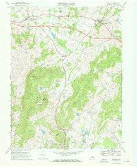
 1977 Thoroughfare Gap1982 Print · USGSNorthern Virginia in the late seventies is captured in this aerial survey as rural tracts began to meet modern expansion. Genealogists and local historians can trace the property lines and road networks around Haymarket, Buckland, and Antioch.
 - 1977 Map of Middleburg, 1982 Print
 1977 Middleburg1982 Print · USGSLoudoun County horse country is captured in the late seventies through detailed aerial photography. Genealogists and researchers can trace the precise layout of properties and roads connecting Middleburg, Aldie, and Halfway.
End of results
Showing maps 1-13 of 13
Top cities of Fauquier County
- Warrenton historical maps
- Bealeton historical maps
- Marshall historical maps
- Remington historical maps
- Opal historical maps
- Catlett historical maps
See more
Frequently asked questions
- What are the different types of historical maps available for Fauquier County?
- What is the oldest map of Fauquier County?
- Where can I purchase historical maps of Fauquier County for my home or office?
- Where can I download high-res historical maps of Fauquier County?
- Are there historical topographic maps available for Fauquier County?
- Is there historical aerial imagery available for Fauquier County?
- Where are historical maps of Fauquier County sourced from?