1950s Maps of Fauquier County, Virginia
Explore 9 historic maps of Fauquier County from the 1950s. These maps offer a rare glimpse into what life looked like during the 1950s — showing old roads, neighborhoods, homes, and landmarks that have changed or disappeared over time.
Whether you're researching your family's past, planning a metal detecting trip, or studying how Fauquier County's landscape evolved across the 1950s, these high-resolution maps are a powerful tool for exploring the history of this region.
- Focus on a specific era: All maps on this page are from the 1950s, giving you a focused view of this time period.
- See what’s changed: Compare century-old streets, trails, and buildings to today's modern landscape using overlays and satellite layers.
- Research with precision: Use these maps for genealogy, historical research, land use analysis, or educational projects.
- View, download, or print: Maps are fully viewable online in high resolution, and can be downloaded or printed for your own records.
Start exploring Fauquier County's history through authentic maps from the 1950s. This is your window into the past.
Fauquier County, VA maps
(9)- 1953 Map of Richardsville
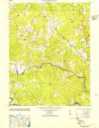 1953 Richardsville1953 Print · USGSThe rural borderlands of Fauquier and Culpeper counties are frozen in time just after the war, centered on the historic river convergence. Genealogists can trace family connections through numerous landmarks like Old School Church, Goldvein School, and Harding Mill.
 - 1953 Map of Somerville, 1954 Print
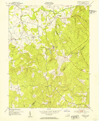 1953 Somerville1954 Print · USGSMid-century Fauquier and Stafford Counties are documented here as rural crossroads give way to the expanding Quantico military lands. Genealogists can trace family footprints through sites like Tacketts Mill, Good Hope Sch, and the Cedar Run Cem.
 - 1953 Map of Storck, 1954 Print
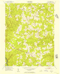 1953 Storck1954 Print · USGSStafford County is shown in the early fifties as a landscape of rural crossroads and river-bordering homesteads. Researchers can locate family landmarks like Dodds Store, historical congregations at Hartwood Ch, and small settlements like Storck and Glendie.
 - 1953 Map of Nokesville, 1954 Print
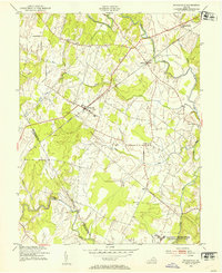 1953 Nokesville1954 Print · USGSPrince William County in the early fifties remains a landscape of rail-side hamlets and winding creek bottoms. Researchers can trace the original footprints of Nokesville and Brentsville or locate rural landmarks like Woodlawn Ch and the grounds of Camp Upshur.
 - 1954 Map of Baltimore
 1954 Baltimore1954 Print · USGSThe Mid-Atlantic region in the early fifties shows a landscape of growing suburban centers and heavy rail corridors. Trace mid-century transit networks and military landmarks from the Aberdeen Proving Ground to the Gettysburg National Military Park.
 - 1956 Map of Baltimore
 1956 Baltimore1956 Print · USGSMid-century Maryland and Pennsylvania are captured here during a period of massive suburban and military growth across the Chesapeake region. Genealogists and historians can trace the rail corridors of the Baltimore & Ohio RR and locate landmarks like Fort McHenry or the Aberdeen Proving Ground.
 - 1956 Map of Charlottesville, 1966 Print
 1956 Charlottesville1966 Print · USGSThe Shenandoah Valley and Blue Ridge are captured in detail during the mid-1960s as the modern interstate system began to emerge. Genealogists and historians can trace rail-connected hubs like Waynesboro or follow the river paths of the Rapidan River and Rivanna River.4 unique versions available
 - 1957 Map of Baltimore, 1964 Print
 1957 Baltimore1964 Print · USGSMaryland and Southern Pennsylvania are shown during the mid-century expansion of the Baltimore-Washington corridor. Researchers can trace the extensive rail lines of the Baltimore & Ohio RR and locate sites like Fort Detrick and Gettysburg National Military Park.5 unique versions available
 - 1957 Map of Washington, 1966 Print
 1957 Washington1966 Print · USGSThe mid-Atlantic region during the mid-fifties and early sixties reveals a landscape of growing suburbs and vital military outposts. Researchers can trace historic river towns and shorelines from Alexandria to the Hooper Islands and St Clements Island.5 unique versions available
End of results
Showing maps 1-9 of 9
Top cities of Fauquier County
- Warrenton historical maps
- Bealeton historical maps
- Marshall historical maps
- Remington historical maps
- Opal historical maps
- Catlett historical maps
See more
Frequently asked questions
- What are the different types of historical maps available for Fauquier County?
- What is the oldest map of Fauquier County?
- Where can I purchase historical maps of Fauquier County for my home or office?
- Where can I download high-res historical maps of Fauquier County?
- Are there historical topographic maps available for Fauquier County?
- Is there historical aerial imagery available for Fauquier County?
- Where are historical maps of Fauquier County sourced from?