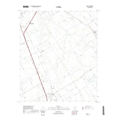
2019 Map of Abbott
USGS Topo · Published 2019About this map
Abbott and Hillsboro anchor the western edge of this central Texas landscape, where the agricultural legacy of Hill County is written in the dense network of county roads and family-named cemeteries. The terrain is defined by the gentle drainage of Cobb Cr and Alligator Cr, which cut through the blackland prairie toward local landmarks like Stapleton Field. Genealogists will find significant value in the distribution of small burial grounds, including Jessie Cem near Chatt and Fatina Cem, which speak to the early settlement patterns of the region. To the northeast, the community of Bynum sits near the headwaters of Ash Cr, while the inclusion of Soil Conservation Service Site 78 Reservoir indicates the critical role of modern water management in this rural corridor. The map effectively traces the evolution of regional transit, from the bypasses of modern thoroughfares to the path of Old Hwy 81.
Find a feature on this map
85 named features on this map. Tap any name to fly to it.
Don’t see what you’re looking for? This feature index may not catch every label — zoom into the map to look around manually.
Map Details
Editions of this 2019 Abbott Map
This is the sole edition of this map. No revisions or reprints were ever made.
Other maps of this area

1891 · Cleburne
USGS Topo · 1:125,000

1892 · Waco
USGS Topo · 1:125,000

1894 · Cleburne
USGS Topo · 1:125,000

1920 · Waco
USGS Topo · 1:125,000

1954 · Dallas
USGS Topo · 1:250,000

1954 · Waco
USGS Topo · 1:250,000

1955 · Waco
USGS Topo · 1:250,000

1956 · Penelope
USGS Topo · 1:24,000

1956 · Abbott
USGS Topo · 1:24,000

1956 · West
USGS Topo · 1:24,000