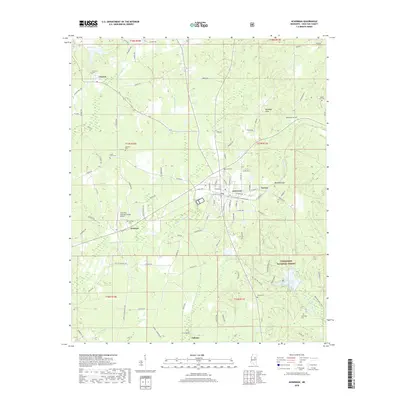
2018 Map of Ackerman
USGS Topo · Published 2018About this map
The town of Ackerman serves as a central hub for this portion of Choctaw County, situated where the Yockanookany River and Tibby Cr drain the surrounding terrain. This landscape is defined by the Noxubee Hills and the expansive Tombigbee National Forest, which covers the southeastern quadrant and includes the recreational waters of Choctaw Lake. The area's history is preserved in its numerous rural burying grounds, such as South Union Cem and Bethlehem Cem, which are scattered among small settlements like Fentress, Tollison, and Tuscan. Transportation and utility infrastructure are prominent, with the Ackerman Choctaw County Airport and a network of named country roads like Chester Mills Rd and Dido Rd connecting these remote communities. The map highlights the transition from the concentrated street grid of Ackerman to the forested ridges and creek bottoms of the national forest.
Find a feature on this map
97 named features on this map. Tap any name to fly to it.
Don’t see what you’re looking for? This feature index may not catch every label — zoom into the map to look around manually.
Map Details
Editions of this 2018 Ackerman Map
This is the sole edition of this map. No revisions or reprints were ever made.
Other maps of this area

1953 · West Point
USGS Topo · 1:250,000

1958 · West Point
USGS Topo · 1:250,000

1963 · West Point
USGS Topo · 1:250,000

1966 · Weir
USGS Topo · 1:24,000

1966 · Tomnolen
USGS Topo · 1:24,000

1968 · Weir
USGS Topo · 1:62,500

1972 · Louisville North
USGS Topo · 1:24,000

1972 · McCool
USGS Topo · 1:24,000

1972 · Highpoint
USGS Topo · 1:24,000

1972 · Double Springs
USGS Topo · 1:24,000