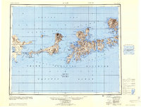
1951 Map of Adak
USGS Topo · Published 1953About this map
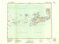
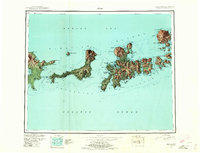
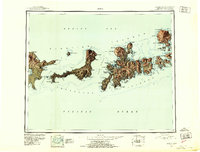
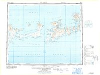
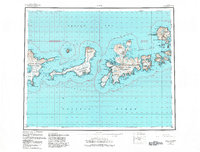
Adak and its strategic surroundings emerge in detail during the early Cold War era, as military and natural features define this portion of the Aleutian Islands. The presence of the Air Force Base near Kuluk Bay highlights the region's importance for trans-Pacific defense and aviation. To the west, the smoking cone of Kanaga Volcano dominates Kanaga Island, while numerous cabins dot the shorelines of Tanaga Bay and Hot Springs Bay, signaling a sparse human presence in a landscape of dramatic coastal features. The intricate shoreline, from the sheltered waters of Clam Lagoon to the complex Bay of Islands, illustrates the navigation challenges and natural harbors of the Third Judicial Division. This 1950s survey reflects the dual identity of the islands as both a critical outpost and part of a National Wildlife Refuge.
Find a feature on this map
134 named features on this map. Tap any name to fly to it.
Don’t see what you’re looking for? This feature index may not catch every label — zoom into the map to look around manually.
Map Details
Editions of this 1951 Adak Map
3 editions found
Other maps of this area

1951 · Gareloi Island
USGS Topo · 1:250,000
1951 · Adak
USGS Topo · 1:250,000
1952 · Atka
USGS Topo · 1:250,000
1954 · Adak
USGS Topo · 1:250,000
1954 · Gareloi Island
USGS Topo · 1:250,000
1957 · Adak
USGS Topo · 1:250,000
1959 · Atka
USGS Topo · 1:250,000
1967 · Adak
USGS Topo · 1:250,000
1983 · Adak
USGS Topo · 1:250,000

2021 · Adak D-1 SW
USGS Topo · 1:25,000