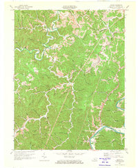
1971 Map of Adams
USGS Topo · Published 1973About this map
Little Blaine Creek snakes through the tight hollows of Lawrence County, anchoring a landscape defined by small-scale coal extraction and agricultural life in the early 1970s. The map illustrates a rural society organized around family-named landmarks and valley bottoms, where Beech Farm sits near the bend of the Levisa Fork. The infrastructure of the era is evident in the Pipeline and Strip Mines that mark the ridges above Evergreen and Adams.
Find a feature on this map
80 named features on this map. Tap any name to fly to it.
Don’t see what you’re looking for? This feature index may not catch every label — zoom into the map to look around manually.
Map Details
Editions of this 1971 Adams Map
3 editions found
Other maps of this area

1886 · Prestonsburg
USGS Topo · 1:125,000

1892 · Prestonsburg
USGS Topo · 1:125,000

1903 · Kenova
USGS Topo · 1:125,000

1904 · Kenova
USGS Topo · 1:125,000

1911 · Louisa
USGS Topo · 1:48,000

1913 · Louisa
USGS Topo · 1:62,500

1914 · Inez
USGS Topo · 1:48,000

1915 · Paintsville
USGS Topo · 1:48,000

1916 · Inez
USGS Topo · 1:62,500

1917 · Paintsville
USGS Topo · 1:62,500