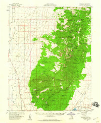
1958 Map of Adamsville
USGS Topo · Published 1960About this map
Adamsville and the Beaver River valley are the focal points of this 1950s survey, showing a landscape defined by industrial extraction and agricultural engineering. The eastern heights are riddled with mining activity, from the Lincoln Mine and Creole Mine in the south to the Beaver View Mine and Schoo Mine further north. This concentration of shafts and prospects suggests a period of intensive geological exploration in the Mineral Mountains.
Find a feature on this map
100 named features on this map. Tap any name to fly to it.
Don’t see what you’re looking for? This feature index may not catch every label — zoom into the map to look around manually.
Map Details
Editions of this 1958 Adamsville Map
2 editions found

Other maps of this area

1885 · Beaver
USGS Topo · 1:250,000

1953 · Ninemile Knoll
USGS Topo · 1:24,000

1953 · Milford Flat
USGS Topo · 1:24,000

1953 · Minersville
USGS Topo · 1:24,000

1953 · Cave Canyon
USGS Topo · 1:24,000

1953 · Richfield
USGS Topo · 1:250,000

1958 · Richfield
USGS Topo · 1:250,000

1958 · Minersville
USGS Topo · 1:62,500

1958 · Thermo
USGS Topo · 1:62,500

1958 · Milford
USGS Topo · 1:62,500