
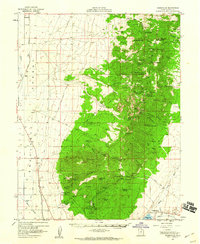
1958 Map of Adamsville
USGS Topo · Published 1960About this map
Adamsville stands as the primary settlement on this landscape, positioned along the Beaver River and a local canal system. In the late 1950s, the area's economy was clearly defined by a divide between the irrigated valley floors and the mineral-rich heights of Bradshaw Mtn and Granite Peak. The mapping records a significant concentration of mining activity, featuring operations like the Creole Mine, Lincoln Mine, and the curiously named School Mine near Little Cedar Cove. The Union Pacific line traverses the western flats, passing the small station at Murdock and Yellow Banks. This survey documents a complex network of springs, such as Old Indian Spr and Jackrabbit Spr, which were essential for sustaining the cattle operations at locations like Ryan Ranch and the numerous sheep-shearing corrals scattered throughout the mountain draws.
Find a feature on this map
89 named features on this map. Tap any name to fly to it.
Don’t see what you’re looking for? This feature index may not catch every label — zoom into the map to look around manually.
Map Details
Editions of this 1958 Adamsville Map
2 editions found
Other maps of this area

1885 · Beaver
USGS Topo · 1:250,000

1953 · Ninemile Knoll
USGS Topo · 1:24,000

1953 · Milford Flat
USGS Topo · 1:24,000

1953 · Minersville
USGS Topo · 1:24,000

1953 · Cave Canyon
USGS Topo · 1:24,000

1953 · Richfield
USGS Topo · 1:250,000

1958 · Richfield
USGS Topo · 1:250,000

1958 · Minersville
USGS Topo · 1:62,500

1958 · Thermo
USGS Topo · 1:62,500

1958 · Milford
USGS Topo · 1:62,500