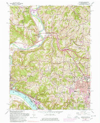
1960 Map of Addyston
USGS Topo · Published 1978About this map
The Ohio River and Great Miami River define this river-valley landscape where the suburbs of Cincinnati meet the industrial and agricultural corridors of the mid-20th century. In the south, the Chesapeake and Ohio Railroad and Baltimore and Ohio Railroad trace the riverfront through Addyston and North Bend, serving a region defined by its rail-and-water transport networks. Residential growth is evident in Bridgetown and Cheviot, while more traditional community anchors like Willsey Cem, Mt Hope Ch, and Township Sch remain scattered across the rolling terrain of Colerain and Whitewater. The landscape transitions from the dense urban expansion near Miamitown to the expansive Miami Whitewater Forest. Distinctive era landmarks such as the Drive-in Theater near Dent and numerous Gravel Pits along the riverbanks highlight the local recreation and resource extraction of the 1950s and 60s.
Find a feature on this map
87 named features on this map. Tap any name to fly to it.
Don’t see what you’re looking for? This feature index may not catch every label — zoom into the map to look around manually.
Map Details
Editions of this 1960 Addyston Map
Other maps of this area

1914 · West Cincinnati
USGS Topo · 1:62,500

1915 · Lawrenceburg
USGS Topo · 1:48,000

1915 · Harrison
USGS Topo · 1:48,000

1915 · Hamilton
USGS Topo · 1:62,500

1917 · Hamilton
USGS Topo · 1:62,500

1928 · Lawrenceburg
USGS Topo · 1:62,500

1932 · Lawrenceburg
USGS Topo · 1:62,500

1943 · Hooven
USGS Topo · 1:24,000

1943 · Lawrenceburg
USGS Topo · 1:24,000

1950 · Covington
USGS Topo · 1:24,000