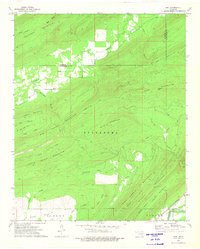
1973 Map of Adel
USGS Topo · Published 1975About this map
Adel and the surrounding timberlands of the Ouachita Mountains define this area along the border of Pittsburg and Pushmataha counties. The landscape is characterized by prominent ridges such as Blue Mountain and Caney Mountain, with the Kosoma Valley opening in the south. These mountain ranges are dissected by numerous waterways, including Jackfork Creek and Clear Creek, creating a complex network of valleys where small settlements like Peveyhouse were established. Industrial presence is concentrated along the southern edge, where the St Louis San Francisco railroad follows the course of the Kiamichi River through Finley. The mapping of the Base Line and the presence of the Town Road reflect the structured division of this landscape, while family-named landmarks like Satterfield Branch and Fobb Creek provide vital clues for genealogical research into the local homesteads of the era.
Find a feature on this map
35 named features on this map. Tap any name to fly to it.
Don’t see what you’re looking for? This feature index may not catch every label — zoom into the map to look around manually.
Map Details
Editions of this 1973 Adel Map
This is the sole edition of this map. No revisions or reprints were ever made.
Other maps of this area

1898 · McAlester
USGS Topo · 1:125,000

1901 · Antlers
USGS Topo · 1:125,000

1901 · Tuskahoma
USGS Topo · 1:125,000

1901 · Alikchi
USGS Topo · 1:125,000

1908 · Tuskahoma
USGS Topo · 1:125,000

1909 · Mc Alester
USGS Topo · 1:125,000

1909 · Tuskahoma
USGS Topo · 1:125,000

1912 · Antlers
USGS Topo · 1:125,000

1925 · Antlers
USGS Topo · 1:125,000

1950 · Mcalester
USGS Topo · 1:250,000