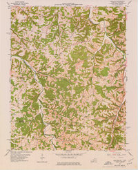
1954 Map of Adolphus
USGS Topo · Published 1976About this map
Louisville and Nashville rail lines cut through the undulating landscape of south-central Kentucky and northern Tennessee in this mid-1950s record. The settlement of Adolphus serves as a local hub near the Allen Co Sumner Co line, where the topography is defined by the winding paths of Middle Fork Drakes Creek and Trammel Fork. This area shows a dense network of rural community life, evidenced by numerous churches and schools such as Stony Point Ch, New Buck Creek Ch, and Walkers Chapel Sch. The map reveals an active extraction economy with several Oil Wells and Gas Wells scattered across the hollows. Local genealogy is well-represented through family-named landmarks and burial sites like Hinton Cem, providing a clear view of the dispersed residential pattern before modern highway development further altered the region.
Find a feature on this map
41 named features on this map. Tap any name to fly to it.
Don’t see what you’re looking for? This feature index may not catch every label — zoom into the map to look around manually.
Map Details
Editions of this 1954 Adolphus Map
2 editions found

Other maps of this area

1921 · Bowling Green
USGS Topo · 1:62,500

1923 · Bowling Green
USGS Topo · 1:62,500

1926 · Scottsville
USGS Topo · 1:62,500

1928 · Adolphus
USGS Topo · 1:48,000

1931 · Lafayette
USGS Topo · 1:62,500

1931 · Adolphus
USGS Topo · 1:62,500

1942 · Gallatin
USGS Topo · 1:100,000

1954 · Drake
USGS Topo · 1:24,000

1954 · Petroleum
USGS Topo · 1:24,000

1954 · Scottsville
USGS Topo · 1:24,000