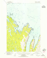
1954 Map of Afognak B-1
USGS Topo · Published 1955About this map
Afognak Island emerges from the Gulf of Alaska in this mid-century survey, showcasing a landscape dominated by the protected reaches of the Chugach National Forest. The eastern coastline is deeply indented by maritime features like Tonki Bay and Seal Bay, with the long stretch of the Tonki Peninsula reaching toward the northeast. This era of mapping relies on aerial photography to document the interior's complex hydrology, revealing a network of freshwater bodies such as Pauls Lake, Laura Lake, and Gretchen Lake that feed into the surrounding saltwater bays.
Find a feature on this map
18 named features on this map. Tap any name to fly to it.
Don’t see what you’re looking for? This feature index may not catch every label — zoom into the map to look around manually.
Map Details
Editions of this 1954 Afognak B-1 Map
This is the sole edition of this map. No revisions or reprints were ever made.
Other maps of this area

1952 · Afognak
USGS Topo · 1:250,000

1952 · Afognak C-1 and C-2
USGS Topo · 1:63,360

1952 · Afognak A-1
USGS Topo · 1:63,360

1952 · Afognak A-2
USGS Topo · 1:63,360

1952 · Afognak B-2
USGS Topo · 1:63,360

1952 · Afognak B-1
USGS Topo · 1:63,360
1952 · Afognak A-0 and B-0
USGS Topo · 1:63,360
1953 · Afognak A-1
USGS Topo · 1:63,360
1953 · Afognak A-0 and B-0
USGS Topo · 1:63,360

1954 · Afognak B-2
USGS Topo · 1:63,360