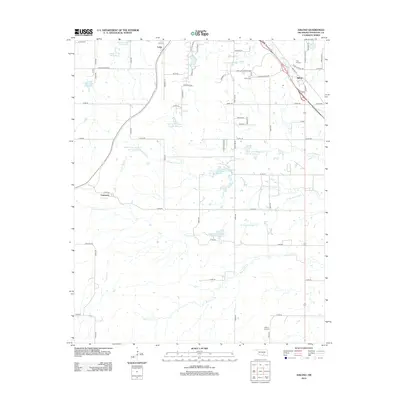
2012 Map of Ahloso
USGS Topo · Published 2012About this map
The settlement of Ahloso and the crossroads of Latta anchor this portion of Pontotoc County, where the landscape is defined by the intricate headwaters of the Canadian River basin. This 2012 survey illustrates a region heavily managed for water conservation, featuring a dense network of reservoirs such as the Upper Clear Boggy Cr Site 36 Reservoir and the Sandy Cr Site 32 Reservoir. These man-made impoundments sit along the rolling drainage divides of Clear Boggy Cr and Bois d'Arc Cr. For local historians and genealogists, the map identifies several significant burial sites, including High Hill Cem near Ahloso and Hickory Hill Cem to the south. The road network, including Lighting Ridge Rd and Keith Rd, connects these rural communities with the former industrial stop at Lawrence, providing a detailed view of the modern rural infrastructure and land use patterns.
Find a feature on this map
69 named features on this map. Tap any name to fly to it.
Don’t see what you’re looking for? This feature index may not catch every label — zoom into the map to look around manually.
Map Details
Editions of this 2012 Ahloso Map
This is the sole edition of this map. No revisions or reprints were ever made.
Other maps of this area

1901 · Stonewall
USGS Topo · 1:125,000

1957 · Stonewall
USGS Topo · 1:24,000

1957 · Ardmore
USGS Topo · 1:250,000

1958 · Francis
USGS Topo · 1:24,000

1958 · Ada
USGS Topo · 1:24,000

1963 · Ardmore
USGS Topo · 1:250,000
1966 · Harden City
USGS Topo · 1:24,000

1967 · Roff South
USGS Topo · 1:24,000

1967 · Ahloso
USGS Topo · 1:24,000
1967 · Vanoss
USGS Topo · 1:24,000