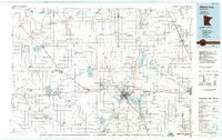
1985 Map of Albert Lea
USGS Topo · Published 1985About this map
Albert Lea serves as the focal point for this Southern Minnesota landscape during the mid-1980s, situated at the intersection of a complex hydrographic and transportation network. The map reveals an extensive system of agricultural drainage, documented through numerous labels like Judicial Ditch No 7 and County Ditch No 20, which transformed the prairie wetlands into productive farmland. The drainage patterns surround natural water bodies such as Geneva Lake and Freeborn Lake, highlighting the managed nature of the regional water table.
Find a feature on this map
118 named features on this map. Tap any name to fly to it.
Don’t see what you’re looking for? This feature index may not catch every label — zoom into the map to look around manually.
Map Details
Editions of this 1985 Albert Lea Map
2 editions found
Other maps of this area

1950 · Mankato East
USGS Topo · 1:62,500

1951 · Mankato East
USGS Topo · 1:62,500

1951 · Mankato West
USGS Topo · 1:62,500

1953 · Saint Paul
USGS Topo · 1:250,000

1953 · New Ulm
USGS Topo · 1:250,000

1954 · Albert Lea
USGS Topo · 1:62,500

1954 · Hayward
USGS Topo · 1:62,500

1954 · Austin
USGS Topo · 1:62,500

1954 · Fairmont
USGS Topo · 1:250,000

1954 · Mason City
USGS Topo · 1:250,000