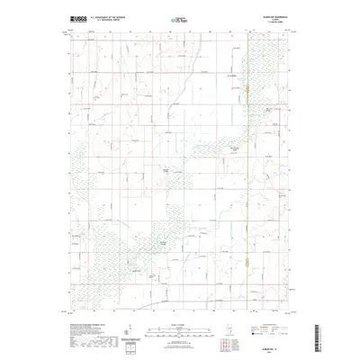
2021 Map of Albion NW
USGS Topo · Published 2021About this map
The Little Wabash River meanders through this portion of southeastern Illinois, carving a complex network of wetlands and seasonal sloughs that define the local topography. This 2021 survey illustrates how the river's movement has created distinct landforms like Old River Island and Rattlesnake Bluff, while extensive drainage works such as the W Side Diversion Ditch and Union Drainage Ditch manage the bottomlands. For genealogists and local historians, the map serves as a detailed record of rural community landmarks, documenting numerous family and church burial grounds including McKendree Cem, Locust Grove Cem, and Thomas Hill Cem. The infrastructure of the area is tied to its water-bound geography, featuring crossings like Massilon Bridge and Hedge Bridge that link the scattered agricultural homesteads across the Wayne and Edwards county line.
Find a feature on this map
80 named features on this map. Tap any name to fly to it.
Don’t see what you’re looking for? This feature index may not catch every label — zoom into the map to look around manually.
Map Details
Editions of this 2021 Albion NW Map
This is the sole edition of this map. No revisions or reprints were ever made.
Other maps of this area

1943 · Albion
USGS Topo · 1:62,500

1946 · Albion
USGS Topo · 1:62,500

1948 · Fairfield
USGS Topo · 1:62,500

1948 · Flora
USGS Topo · 1:62,500

1949 · Olney
USGS Topo · 1:62,500

1949 · Flora
USGS Topo · 1:62,500

1958 · Belleville
USGS Topo · 1:250,000

1962 · Belleville
USGS Topo · 1:250,000

1970 · Enterprise
USGS Topo · 1:24,000
1971 · Golden Gate
USGS Topo · 1:24,000