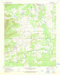
1971 Map of Albion
USGS Topo · Published 1990About this map
The Kiamichi River flows through this corner of the Choctaw Nation, where the rugged terrain of the Potato Hills meets a network of small settlements and family burial grounds in the early 1970s. The St Louis - San Francisco railroad corridor serves as the primary industrial artery, connecting Talihina and Albion across the county lines of Latimer, Le Flore, and Pushmataha. Local life is anchored by numerous spiritual and community landmarks, such as the Evangelistic Tabernacle and Head Ch, alongside a striking concentration of historic cemeteries including McIntosh Cem, Armstrong Cem, and Noah Cem. Drainage patterns are defined by many winding waterways like Rock Creek, Jackson Creek, and Clear Creek, which navigate the elevation changes before joining the river. Small-scale industrial activity is evidenced by scattered Gravel Pits, while the Roadside Park near Albion suggests the importance of early highway travel in this rural Oklahoma landscape.
Find a feature on this map
33 named features on this map. Tap any name to fly to it.
Don’t see what you’re looking for? This feature index may not catch every label — zoom into the map to look around manually.
Map Details
Editions of this 1971 Albion Map
2 editions found
Other maps of this area

1900 · Winding Stair
USGS Topo · 1:125,000

1901 · Tuskahoma
USGS Topo · 1:125,000

1908 · Tuskahoma
USGS Topo · 1:125,000

1909 · Tuskahoma
USGS Topo · 1:125,000

1909 · Winding Stair
USGS Topo · 1:125,000

1940 · Red Oak
USGS Topo · 1:62,500

1943 · Red Oak
USGS Topo · 1:62,500

1950 · Mcalester
USGS Topo · 1:250,000

1962 · McAlester
USGS Topo · 1:250,000

1965 · McAlester
USGS Topo · 1:250,000