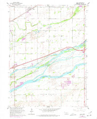
1962 Map of Alda
USGS Topo · Published 1977About this map
Alda anchors the northwestern corner of this Hall County landscape, situated along the Union Pacific railroad corridor. The terrain is dominated by the braided channels of the North Channel, Middle Channel, and South Channel Platte River. These waterways carve out significant landforms, including Shoemaker Island, Mormon Island, and Indian Island, which reveal the complex hydrology of the Platte River basin before modern channelization. Numerous Gravel Pits concentrated near the Wood River indicate a local economy tied to aggregate extraction.
Find a feature on this map
31 named features on this map. Tap any name to fly to it.
Don’t see what you’re looking for? This feature index may not catch every label — zoom into the map to look around manually.
Map Details
Editions of this 1962 Alda Map
3 editions found
Other maps of this area

1892 · Grand Island
USGS Topo · 1:62,500

1894 · Kenesaw
USGS Topo · 1:62,500

1895 · Grand Island
USGS Topo · 1:62,500

1895 · Wood River
USGS Topo · 1:62,500

1896 · Wood River
USGS Topo · 1:125,000

1898 · Grand Island
USGS Topo · 1:125,000

1955 · Grand Island
USGS Topo · 1:250,000

1957 · Grand Island
USGS Topo · 1:250,000

1958 · Grand Island
USGS Topo · 1:250,000

1962 · Prosser
USGS Topo · 1:24,000