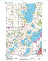
1966 Map of Alexandria West
USGS Topo · Published 1995About this map
Glacial lakes and wetlands define the landscape of Douglas County in this mid-1960s survey, where the northwestern outskirts of Alexandria meet a complex network of waterways. The transition from the more settled southern township of La Grande toward the rural northern reaches of Ida is marked by numerous family-named landmarks and institutions. Education and community life are grounded in rural landmarks like the Glendale Sch and Lake Louise Sch, alongside several historic burial grounds including St Lukes Cem and Lake Ida Cem.
Find a feature on this map
64 named features on this map. Tap any name to fly to it.
Don’t see what you’re looking for? This feature index may not catch every label — zoom into the map to look around manually.
Map Details
Editions of this 1966 Alexandria West Map
2 editions found
Other maps of this area

1953 · Brainerd
USGS Topo · 1:250,000

1953 · Saint Cloud
USGS Topo · 1:250,000

1957 · Brainerd
USGS Topo · 1:250,000

1957 · Saint Cloud
USGS Topo · 1:250,000

1958 · Saint Cloud
USGS Topo · 1:250,000

1958 · Brainerd
USGS Topo · 1:250,000

1965 · Brainerd
USGS Topo · 1:250,000

1966 · Brandon
USGS Topo · 1:24,000

1966 · Alexandria West
USGS Topo · 1:24,000

1966 · Farwell
USGS Topo · 1:24,000