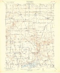
1915 Map of Alger
USGS Topo · Published 1915About this map
Alger and Harrod serve as primary rail stops along the Erie RR in this detailed 1915 study of the western Ohio plains. The landscape is defined by an extensive network of drainage ditches, such as Cottonwood Ditch and Cooney Ditch, which transformed the marshy terrain of the Scioto Marsh into productive agricultural land. This complex water management system feeds into the Scioto River, while the southern reaches of the map show the northern shores of Indian Lake, featuring Snow Island and Turkeytrot Point.
Find a feature on this map
93 named features on this map. Tap any name to fly to it.
Don’t see what you’re looking for? This feature index may not catch every label — zoom into the map to look around manually.
Map Details
Editions of this 1915 Alger Map
4 editions found

Other maps of this area

1905 · Arlington
USGS Topo · 1:62,500

1906 · Lima
USGS Topo · 1:62,500

1906 · Columbus Grove
USGS Topo · 1:62,500

1907 · Bluffton
USGS Topo · 1:62,500

1907 · Arlington
USGS Topo · 1:24,000

1908 · Columbus Grove
USGS Topo · 1:62,500

1913 · Alger
USGS Topo · 1:48,000

1913 · Bellefontaine
USGS Topo · 1:48,000

1913 · Sidney
USGS Topo · 1:62,500

1913 · East Liberty
USGS Topo · 1:62,500
Featured Places
- Alger, Marion Township
- Waynesfield, OH
- Belle Center, Richland Township
- Roundhead, Roundhead Township
- McGuffey, Marion Township