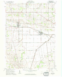
1961 Map of Alger
USGS Topo · Published 1962About this map
The Erie Lackawanna railroad forms the industrial backbone of this Hardin County landscape, connecting the village of Alger with nearby McGuffey. This 1961 survey illustrates a region defined by extensive drainage engineering, where numerous ditches such as Cottonwood Ditch and Cooney Ditch have been cut to manage the low-lying terrain surrounding the Scioto River. The map reveals a dense network of family-linked landmarks and rural institutions, including Quickstep Ch and a series of neighborhood burial grounds like Carman Cem and Preston Cem.
Find a feature on this map
42 named features on this map. Tap any name to fly to it.
Don’t see what you’re looking for? This feature index may not catch every label — zoom into the map to look around manually.
Map Details
Editions of this 1961 Alger Map
2 editions found
Other maps of this area

1905 · Arlington
USGS Topo · 1:62,500

1907 · Bluffton
USGS Topo · 1:62,500

1907 · Arlington
USGS Topo · 1:24,000

1913 · Alger
USGS Topo · 1:48,000

1915 · Alger
USGS Topo · 1:62,500

1915 · Kenton
USGS Topo · 1:62,500

1943 · Alger
USGS Topo · 1:62,500

1944 · Kenton
USGS Topo · 1:62,500

1950 · Marion
USGS Topo · 1:250,000
1960 · Roundhead
USGS Topo · 1:24,000
Featured Places
- Alger, Marion Township
- McGuffey, Marion Township
- Liberty Township, OH
- Lynn Township, OH
- McDonald Township, OH