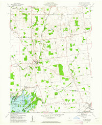
1960 Map of Roundhead
USGS Topo · Published 1962About this map
Indian Lake and the northern reaches of Indian Lake State Park dominate the southern portion of this landscape, where numerous named islands like Seminole Island and Long Island suggest a developed recreational geography. In the early 1960s, the village of Roundhead serves as a local hub near the Scioto River, while the New York Central rail line cuts through the southeastern corner near Belle Center. The rural interior is defined by a systematic grid of township roads and agricultural drainage, including the Military River and several gravel pits. Genealogists will find a high density of family-named cemeteries and rural institutions, such as McArthur Cem, Old Fairview Cem, and Mt Zion Ch, which anchor the small crossroads of Jumbo and Jump. The presence of the Nickell Landing Field near the river indicates the period's small-scale aviation footprint in Hardin and Logan Counties.
Find a feature on this map
53 named features on this map. Tap any name to fly to it.
Don’t see what you’re looking for? This feature index may not catch every label — zoom into the map to look around manually.
Map Details
Editions of this 1960 Roundhead Map
Other maps of this area

1913 · Alger
USGS Topo · 1:48,000

1913 · Bellefontaine
USGS Topo · 1:48,000

1913 · East Liberty
USGS Topo · 1:62,500

1915 · Alger
USGS Topo · 1:62,500

1915 · Bellefontaine
USGS Topo · 1:62,500

1915 · East Liberty
USGS Topo · 1:62,500

1915 · Kenton
USGS Topo · 1:62,500

1943 · Alger
USGS Topo · 1:62,500

1944 · East Liberty
USGS Topo · 1:62,500

1944 · Kenton
USGS Topo · 1:62,500