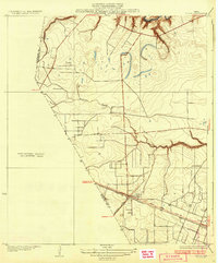
1932 Map of Algoa
USGS Topo · Published 1932About this map
Algoa stands as a rail-dependent hub on the Texas coastal plain at a time when the Missouri Pacific and Gulf Colorado and Santa Fe railroads intersected south of Dickinson Bayou. The landscape reflects a period of infrastructure development, with State Highway No 38 cutting a straight line through the territory toward the coast. This 1932 edition, based on 1929 surveys, includes names of the Galveston County Commissioners Court like E. B. Holman and engineer C. C. Washington, grounding the map in the local civil administration of the era. The intricate drainage patterns of Chigger Creek and Magnolia Bayou illustrate the low-lying terrain near the Brazoria and Harris County lines, where early road networks and rail lines negotiated the prairie wetlands.
Find a feature on this map
9 named features on this map. Tap any name to fly to it.
Don’t see what you’re looking for? This feature index may not catch every label — zoom into the map to look around manually.
Map Details
Editions of this 1932 Algoa Map
3 editions found
Other maps of this area

1916 · Genoa
USGS Topo · 1:24,000

1916 · Seabrook
USGS Topo · 1:24,000

1920 · Seabrook
USGS Topo · 1:31,680

1920 · Genoa
USGS Topo · 1:31,680

1920 · Mykawa
USGS Topo · 1:31,680

1929 · Dickinson
USGS Topo · 1:24,000

1929 · Algoa
USGS Topo · 1:24,000

1929 · Hitchcock
USGS Topo · 1:24,000

1932 · Algoa
USGS Topo · 1:31,680
1932 · Genoa
USGS Topo · 1:31,680